"I will never kick a rock"

Monthly archive

July 2021

Nanny Goat Hill July 29, 2021

in Uncategorized by

Nanny Goat Hill; Part One, the abyss

On the Rocks, The Woodstock Times

Updated by Robert and Johanna Titus


Development is always a controversial subject in the Hudson Valley. There are those who would ban it altogether, while others decry how little there is. Currently there are plans for a hotel and conference center along Partition Street, near Esopus Creek in the heart of Saugerties. Several acres of land are involved. Part of this is a little knoll called Nanny Goat Hill. The name goes back to the 19th century when, supposedly, goats grazed here. As we understand it, the plans call for Nanny Goat Hill to be dynamited, with 19,000 cubic yards of rock hauled off to make space for a parking garage.

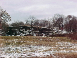
But some residents would like to save the hill and make it into a small park. They contacted us and wondered if we could be of any assistance in evaluating this plan. We generally try to keep this column from being political, and, as we do not live in Saugerties, we don’t think we should be vocal in the town’s decision making, but there is no harm that can come from looking at the geological heritage of this site. We have done so.

It has always been our opinions that nearly any site has an interesting geological story. Each place has a longitude and latitude. These dots on the map have been where they are for more than 4 1/2 billion years, and a great deal has happened during this time. The Nanny Goat Hill site has witnessed a lot of history and some of it is represented in the bedrock while more is carved into the landscape of the hill itself. We enjoyed our visit to Nanny Goat Hill.

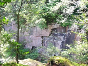
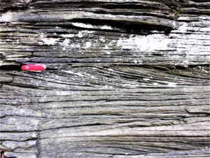
This location displays some very nice and sizable ledges of bedrock. The unit exposed here is called the Austin Glen Formation which is part of the Normanskill Group. The geological jargon may be dull, but the story behind these units is quite interesting. All of this sequence consists of thick gray sandstones alternating with nearly black shales. These are sedimentary rocks, and they once were, of course, sediments: sands and muds to be specific. That’s where it gets interesting. The sands and muds accumulated at the bottom of one of the deepest oceans that ever existed.

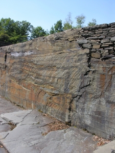
If you visit this site, you can see horizontal strata of sandstone and some shale, right from the sidewalk. Each stratum was once at the bottom of the ocean. This ocean was a marine trench. To see something like this today you might have to visit the Marianas Trench of the western Pacific Ocean. There the water is about seven miles deep. That’s a lot deeper than Mt. Everest is tall. Think about that. Our ocean, the “Normanskill Sea,” might only have been four miles deep and that is just guessing, but it was deep, very, very deep.

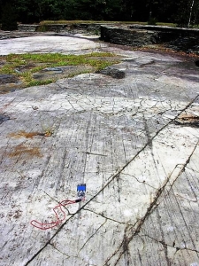
At Nanny Goat Hill there are places where you can stand on such strata and you are, when you do so, quite literally standing on the bottom of such a deep ocean. In your mind’s eye you can look around and see nothing but blackness, you can feel the intensity of the cold, and hear the absolute silence of the abyss. But, more than anything else, you can feel the pressure that is generated by four miles of very heavy seawater. If you understand all this, then Nanny Goat Hill is a real adventure.

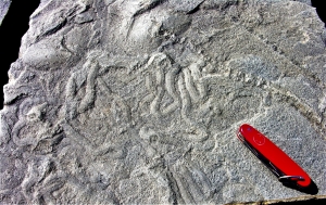
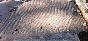
There is more. The majority of the rocks are those dark gray sandstones. But in between these strata are much thinner black shales. The sandstones represent what geologists call turbidity currents. Those are the product of submarine avalanches. This ocean bottom was not only deep, but it was also very steep. Periodically, earthquakes would jar loose great masses of sand, and these would form avalanches that tumbled down into the depths. After an avalanche was over, long periods of quiet would follow and that’s when the black shales came to be deposited as “normal” seafloor mud. This was a “hurry up and wait” sort of seafloor.

An obvious question for a geologist to ask is: “Where did all that sand come from?” There is only one answer. Off to the east there was a rising mountain range. These peaks are called by geologists the Taconic Mountains and they made up the original Taconic Range. Mountain building must have come to something of a peak (pardon the pun) and so, as we looked off to the east we could see mountains towering above the horizon, reaching elevations that would rival today’s Rocky Mountains or the Andes. These rising mountains were weathering and eroding, and those processes created the sand. It traveled down mountain slope streams and was carried out to sea. Eventually the sand was caught up in gravity slides and came to rest on a seafloor that would someday be Nanny Goat Hill.

All in all, our visit to Nanny Goat Hill was a bit of an adventure. We had taken ourselves back hundreds of millions of years through time and miles beneath the sea. We had witnessed rising mountains and great marine avalanches. It was, in short, just another day in the life of two minor league geologists.

Contact the authors at randjtitus@prodigy.net. Join their facebook page “The Catskill Geologist.”


Yellow alert – July 22, 2021

in Uncategorized by

Yellow Alert?

Stories in Stone – April 17, 2007

The Columbia County Independent

Updated by Robert  and Johanna Titus

  LANDSLIDE IN GLENMONT

We have, recently (2007), had a growing sense that something has been going on geologically, here in our upper Hudson Valley. We think a pattern has been developing. Scientists notice patterns and we seek to understand them. We had better explain.

We commonly drive past the Gilboa Reservoir. Lately, the water has been pouring over the top of the dam. (2007) That’s unusual; most of the time the reservoir is well below the dam’s top, sometimes the reservoir is nearly empty. It’s easy to say that it has just rained a lot recently, but we wonder.

Over the last few years there have been a number of damaging slumps in the upper Hudson Valley. First came the Delmar slump, south of Albany, which put a major road out of commission for quite some time. It had been built on the muddy sediments of an old ice age lake, Glacial Lake Albany. The sediments simply gave way and slid into Normans Kill. Well, these things happen, or so we thought at the time.

But then, last year there was another slump, this one in Schenectady. The edge of an old Lake Albany delta slid downhill and that doomed six homes. Soon we had a small slide just a mile from the Titus family home in Freehold. Again, this spring, we have seen still another nearby bank give way and now it seems to be oozing water. That’s too close for comfort.

Slumps are an ongoing problem in the Hudson Valley, and we have written about them before, but there seem to be a lot of them lately. Two weeks ago, there was a new slump in Amsterdam. This one also seems to have involved the sediments of another ice age lake delta. That’s alarming; why are these events coming at such a rapid rate?

But then it got even worse. We began receiving emails from people in Valatie, complaining about flooding basements. Three houses on New Street have been experiencing serious problems for weeks. Basements flood, that’s their job, but some of these folks claim that they have never seen the likes of this even after decades of residence and they are worried.

All this may just be coincidence and might mean next to nothing. Or all this may just indicate that we have had a lot of rain lately. That would explain this year’s problems, but it would not tie in the events of recent years.

In the end, it seemed to us that there was enough to warrant a little investigation. It looks to us, on the face of it, that the region’s water tables have been rising and that the recent heavy rains have triggered a series of problems. This trend may be something that has been developing over the last several decades. Can we document this the way that scientists should, and can that lead to an explanation? Well, we can try.

We checked with the National Oceanic and Atmospheric Administration website and found some interesting things. New Yorkers have seen some climate change over the past century. Our average temperature has climbed only about one degree Fahrenheit. More interestingly, however, our rainfall has climbed about six inches, from 36 to 42 inches/year, that’s 16 percent.

If we have seen a lot more rainfall, then it follows that there should be more groundwater and higher water tables. Add a few heavy rains and it seems logical that basements would start to flood, and slumps might be triggered. People might well remember that these things didn’t happen in the distant past because they really couldn’t have.

What we are suggesting is that if we have a wet summer or, worse, a snowy winter and rainy spring next year then we may see serious problems. Is all this good science? Certainly not, it is the result of just a little work over a short period of time in response to some rapidly occurring events. It’s not scientific theory, just hypothesis, but maybe you can help; have you noticed any unusual basement flooding, or anything else peculiar?

Contact the authors at randjtitus@prodigy.net. Join their facebook page “The Catskill Geologist.”

The Heart of Darkness (in the Catskills)

in Uncategorized by

The Heart of Darkness

The Kaatskill Geologist 

Kaatskill Life – Fall  2004

Updated by Robert and Johanna Titus


There is, if you can imagine it, a “darkest Catskills,” a place where Nature still truly prevails. It is a wholly untamed wilderness where, even in our time, people are sometimes afraid to tread. Once you have entered it, it becomes a place that seems to draw you on but, no matter how deeply you go into it, and no matter how difficult your trek has become, it will only get worse. Still, it is a place that teases you on with promises of natural beauty that numbs your normal cautions. It is a dangerous place, but, in the end, it is worth the risks; it is one of the most beautiful localities in all of our mountains and that is saying a lot. But you always have to remember that one thing: no matter how difficult it is, it will only get worse. It is the canyon of Plattekill Clove.


You can never think about Plattekill Clove without comparing it to its big brother – Kaaterskill Clove. Each is a very large, deep ravine cut into the “Wall of Manitou:” that great ledge we call the Catskill Front. Kaaterskill Clove is longer

and deeper, and it is a rugged and majestic place. And Kaaterskill Clove also seems to be an older geological feature. It may well be more than 100,000 years old and, in that time, it has been able to carve a canyon bottom that rises relatively smoothly from the Hudson River lowlands to Haines Falls. Plattekill is shorter and not quite as deep, but it is fundamentally different; here erosion has had time to create waterfalls, but not the time to destroy them. This whitewater stream, as it descends its canyon pauses at each sandstone ledge. Often it has created deceptively pretty little pools of water and then tumbled over the edge of the cliff to make a powerful waterfall. There is a geological irony here. The sandstone ledges that cap our modern falls are the lithified sediments of Devonian age rivers. The sands of ancient rivers block the flow of modern creeks.


Thus, it is that stratigraphy has given the Catskill Front a series of very rugged ledges, and, at Plattekill, each one of them has its own waterfalls. Back at the older Kaaterskill Clove the creek there has had time to erode its way through most of those ledges and only a few falls remain. Kaaterskill Clove is like a deep old wound that has had enough time to do some healing. Plattekill is more like a fresh stab. Both are rugged, both are beautiful, but Plattekill is more jagged and raw. Nature has done no healing in this canyon.

We have written about Plattekill Clove before (Kaatskill Life, spring, 1999), but only about the clove as it can be seen from the many wonderful scenic vantage points looming above it.  There is a whole different clove, and that is the one that you can only see from down below. It can be, quite literally, the heart of darkness. On an overcast day, as you ascend this canyon and the walls rise above you, it actually gets dark.

It once was a popular tourist attraction, and back in the late 19th century there were several hotels here. Many old postcards date back to then, but those times are long gone. Today, not many people hike the great canyon. It is a very rough place and there are no marked trails; it is no place for the novice hiker. And it is not a very easy place for the advanced hiker either. We, and some of the best hikers that we know, have actually confessed to have been intimidated by its reputation. But the canyon does beckon and one August day four of us decided to give it a try.

The lower canyon is a deception; it seems to be there with the purpose of luring you on. It’s picturesque but surprisingly easy to hike. The end of the last ice age gave this part of the clove a deep blanket of soft sediment, something we call an alluvial fan of sand and gravel (Kaatskill Life, spring, 2002). The post ice age flow of water cut through those gravels and created a beautiful ravine. You can follow an easy unmarked trail along the rim of that ravine and gaze down into the rugged stream below and enjoy the walk immensely. But remember, this is Plattekill; it only gets worse ahead.

As we said, there are many waterfalls in Plattekill; it’s not easy to count them, but traditionally the number is 17. We reached our first and it was a beauty. Among the nicest things about the falls of Plattekill are the “plunge pools” that form beneath them. Over the millennia, high flows of water have tumbled over the falls and carved out deep pools at their bases. These form very fine swimming holes which are real attractions. We found the messy evidence of much swimming and picnicking and general partying at the base of our first fall. But we had no time for any of this ourselves; we followed an easy trail up and over the falls and pushed on. Now we were really in the wilderness that makes up Plattekill Clove.

Soon we saw the first of many unusual boulders of the trek; it was large, five feet across, well weathered and nicely rounded. We looked it over carefully and found it to be a “foreigner.” It was not composed of Catskill bluestone as it should have been. Instead, it was a rock called gneiss. Gneiss is a metamorphic rock, which means it formed under very high temperatures and pressures; this one had formed in the Adirondacks or New England, and it had been brought down the Hudson Valley and left here by the glaciers. We would look for and find quite a few others during the rest of the day. They spoke to us of the ice age glacier that had preceded us here. Maybe fourteen thousand years ago a tongue of ice had climbed the clove, all the way to the top. It had carried boulders with it and left them here when the climate warmed. Now those boulders were slowly traveling back down the clove. Plattekill tells a lot of stories when you look into its rocks. We pushed on.

At two hours into our ascent, we passed a small tributary stream coming in from the right and then, very soon, another one on the left. These were what geologists call “parallel streams.” They plunge down very steep slopes and are, all of them, nearly vertical, they are almost as much waterfalls as they are streams. Vertical streams are, of course, all parallel and hence the term. Our second one has had a number of names: it has been called “Black Chasm Creek,” and “Coal Kiln Creek,” and “Cold Kill Creek,” and “Cross Clove Creek.” The name doesn’t matter much, but we would not soon forget this little stream. On this day there was very little water in it, but there were a very large number of very big bluestone boulders (fig. 5). Such steep streams can transport very large boulders with little difficulty; they get a large boost from gravity. For millennia, both of these streams had been funneling these great rocks out of the highlands above. This journey was not a very long one, but it was a very slow one. These rocks will be tumbling for many more thousands of years. Plattekill is like some sort of reverse Diogenes, it seems to be forever rolling rocks down the hill.

The idea that there can be streams of boulders was not new to us, but we were most impressed to see this one. We continued up the main canyon and in a hundred yards or so we encountered another stream of boulders, this one being in Plattekill Creek itself. There were hundreds of them, and many were more than ten feet across. We wondered how much they weighed. We had not much noticed it, but Plattekill had slowly become a steeper canyon. Its slope was great enough so that it too was transporting the heavy weight of big boulders. We had seen Plattekill Clove as a fresh wound into the Catskill Front. Now the metaphor was working very well. Our Catskill wound was now bleeding streams of boulders.

Next, we entered into what seemed like a whole new realm of Plattekill. Slowly, we found our attentions drawn upwards, as great vertical cliffs of sandstone came to tower above. And tower is just the right word; those walls were sheer cliffs – left and right -rising what seemed to be a hundred feet or more. At the same time, the canyon seemed to narrow, and we found ourselves being funneled into a tighter squeeze. Here, we saw no more boulders, instead the centuries of intense spring floods had flushed this part of the chasm clear. On this August day, the flow was very low, but the months of March and April must have witnessed a far more powerful flume of meltwater. We didn’t like to think about the angry gray flows of that season. There are some things that humans should not go and see, and this was one of them. We pushed on clambering up the steep and often slippery bare red bedrock. The clouds rolled in high above and now the light in the deep canyon began to dim; we were truly in the heart of darkness.

But you must always remember: no matter how difficult Plattekill Clove is, it only gets worse. Now, after four hours of serious hiking, we found ourselves at the base of Green Falls, perhaps the tallest waterfalls of Plattekill Clove. Much to our dismay, these falls were a shear cliff and offered no hope of being climbed. The thought of turning back was too dismaying. But none of us had been here before and it seemed that there was no way to go on. Only to our left, however, there was there any glimmer of hope for completing our ascent; there lay the now dry channel of another stream of boulders. It was either climb this or turn tail and retreat down the canyon. We began what would be an arduous ascent; it is a 270 foot upward climb over a chaos of rough, angular boulders. We made it, but it took quite a while, and the reward was further disappointment. There at the top of our hard scramble was still another impediment.

Before us was another 20-foot-thick ledge of sandstone, we had seen so many already on this day, but this one seemed of offer no way at all to pass up and over it. In Plattekill, it only gets worse. Once again, we faced the irony of being blocked by a nearly 400-million-year-old, Devonian stream channel as we tried to ascend a modern creek. We explored to our left and to our right and found nothing but that vertical sandstone citadel. Now, it was getting late: should we climb all the way back down the Clove, a five-hour retreat that might carry us into true nighttime darkness? Or should we press on in search of an escape route over this ledge? This was a difficult moment.

Well, all turned out, we explored farther to the right and found a dead tree lying against our ledge. It didn’t have many branches left, but there were just enough to make an “Indian ladder” out of it. We pushed and pulled each other up the ladder and soon found a flat trail to the base of Plattekill Falls and the trail out of the upper clove. Our moods improved greatly.

Before breaking up, our little group climbed out to the overlook above the Devil’s Kitchen and there we saw the solution to the biggest mystery of the day. Why did Plattekill Clove persist in getting steeper and rougher as we climbed to its top? In an instant we saw the answer. At the Devil’s Kitchen we saw that the sandstones here are broken by fractures of the sort that geologists call “joints.” Joints are smooth flat fractures of the rocks. They are like faults, except that there has been no motion of the rocks on either side. Here, as is always the case, the joints are closely spaced and, those of Plattekill Clove, cross the clove

along a northeast to southwest compass direction. That means that as large masses of rock break loose and fall, they leave vertical walls that loom above the head of the clove. The fracturing was concentrated in the upper reaches of the clove, and this had accounted for the ever-increasing steepness. The broken joints had also, no doubt, provided the bulk of the boulders that we had been seeing all day long. Our conquest was now complete; not only had we climbed Plattekill Clove, but also, we had solved one of its best geologic mysteries.

After our long and strenuous day, our companions were happy to disperse and return to their homes. We, however, had a special privilege: the Catskill Center for Conservation and Development had loaned us their little red cabin for the night. That’s the one at the top of Plattekill Falls. We would spend a very nice evening on its porch listening to the roar of the water passing into the great clove that was now, happily, beneath us.

Late in the evening, more clouds rolled in, and all around us it became very dark. The air was still, and the summer insects were very loud. From high up above, on Plattekill Mountain, came the cry of a single coyote. It was quickly joined by the howls of a whole pack of them. We are told that they do this after making a kill. This is a wild place.

Contact the authors at randjtitus@prodigy.net. Join their facebook page “The Catskill Geologist.”

Opus 40 Bedrock Geology

in Uncategorized by

A time park? A Devonian park?

On the Rocks, The Woodstock Times; May 5, 2011

Updated by Robert and Johanna Titus


Opus 40, that exotic sculpture executed by Harvey Fite, started out as a piece of art; it may end up being a Saugerties town park. If so, it might be regarded as a “time park” where visitors can travel into the past: 380 million years back to the Devonian age. The original quarry here was cut into a massive Devonian sandstone and that means it cut into a petrified river channel. That’s typical in the Catskills; wherever you see thick sandstones, you can pretty much count on them being the deposits of an ancient river. Such ancient rivers flowed across the world-famous Catskill Delta, the great river delta that deposited all of the sediment that came to be petrified to now make up our mountains.

We visited Opus 40 to explore this ancient time. We found 14 feet of fairly continuous river sandstones. It occurred to us that this must have once been a very big river. It had to have been more than 14 feet deep in order to accommodate all that sand. That’s a lot of river! We were getting interested. This river certainly deserved a name and so we decided to call it the “Opus River.”


The first four feet of Opus River sediments were made up of flat-lying strata. That is typical of sands deposited well out in the middle of a river’s channel. It suggests a moderate and steady current. We could envision the clear water currents speeding along with a fair amount of sand dancing down the bottom of the channel.

There had once been living creatures in the Opus River. Along the edge of one of Harvey Fite’s walls we found a fascinating fossil. It is not a body fossil, not a bone or shell. Instead, it is something called a trace fossil. This one is a burrow of the animal. We don’t know what kind of animal it was, but worm is a good guess. We found ourselves gazing at the trail of this animal. We were sharing a few minutes in the life of an ancient worm!


There were few other recognizable fossils; We think that the river currents were simply just a little too powerful for most animals. The strength of those currents became manifest when we found more evidence. There were several horizons of what are called ripple marks. These little ripples were the product of river currents passing across the bottom and sculpting the sand. All in all, a lot of evidence of current activity was turning up in the beds of the Opus River. It had certainly been a busy place.

So, by now we knew we were looking at a big and powerful river. That was pretty good, but it would soon get a lot better. Those first four feet of flat-lying strata graded upwards into what is called planar cross bedding. These were strata that displayed a recognizable slope to their strata. That’s unusual; most sedimentary beds are horizontal. These formed as what you might think of as river-bottom dunes. Imagine large masses of sand being swept along by a very powerful flow. The steady current carried the sand along and deposited it on the sloping front of the “dune,” That’s what we were looking at. We are used to seeing planar cross bedding, but we were surprised to see the scale of these deposits; they were big and thick bedded. Once again, we sensed that we were looking at a very deep and powerful river.


Great rivers are subject to great flood events, and we would find evidence for one of those. We found, on the back wall of the quarry, an erosional surface. This, we suspect, represented moments of the onset of a very big flood. As waters swelled up the banks of the Opus River, the current picked up. Currents cut into the older sediments below and scoured the river bottom. The flood then crested and later its flow abated. As the flood subsided, new deposits of sand filled in the scour surface, hence the feature we were looking at.

This must have been a very substantial flood; we could imagine the raging flow of the river at the peak. We imagined The Woodstock Times with banner headlines screaming about the damage and destruction. But this had been the Devonian time period; there had been no newspapers then. Nobody had recorded these awful floods, and nobody had recalled them until we came along. Geologist read newspapers of stone.

They say that a good sculptor can look into a large stone and see the statue within. We are not sculptors, but we had done exactly that. We had not chiseled an image; we had looked into the rock and seen Nature’s sculpture, already there.

Perhaps it would be better to compare the Opus River to Pompeii, a city frozen in time. Harvey Kite’s river is a petrified stream and, quite precisely like Pompeii, it is frozen in time. Its currents were flowing along and then they stopped in their “tracks” and “froze” into rock. Its ripple marks stopped moving downstream and they have remained in place for 380 million years. Sand grains bounced down the fronts of the river’s dunes, then halted and never moved again, frozen solidly in time. Like citizens of Pompeii, its burrowing animals were caught forever as images in stone. Everything here is frozen in time. That is what sculpture is all about.

Reach the authors at randjtitus@prodigy.net. Join their facebook page at “The Catskill geologist.”

Opus 40 in the Ice Age 7-1-21

in Uncategorized by

An Ice Age Opus?

On the Rocks, The Woodstock Times; April 11, 2011

Updated by Robert and Johanna Titus


Opus 40 is one of the strangest and most truly unique sculptures to be seen anywhere. It was the concept and, perhaps, obsession of Harvey Fite who worked on it from 1939 to 1976 when he died with his boots on, still at work on his creation. The site had been, originally, just another abandoned bluestone quarry in an area with very many of them. If you spend enough time exploring, you can find them all over the place. They lie off in the woods, almost buried in the forests. They are landscape scars, slowly healing from the commercial wounds of a onetime important bluestone industry.

Almost all the others have been left to become overgrown. But Fite had something else in mind. He spent decades moving rocks and boulders around to create his sculpture. Had he been doing this as an inmate at some prison, it would have been a scandalous example of the abuse of “hard labor.” Perhaps Fite might have been among those who protested such an injustice, but he was the one who inflicted this hard labor upon himself. Sadly, he did not live to see his hard labor completed and, in many ways, it remains a “work in progress.” Was this a mission, an obsession, or just what it was supposed to be: a work of art? Who knows, but it’s quite the place to visit.

The current owners (2011) of Opus 40 are interested in selling the property. One proposal floating around is for the town of Saugerties to buy it and turn the place into a park. It’s a controversial notion, especially in these economically depressed times. It’s not any of our business what the people of Saugerties choose to do or not to do, but it is our business to speak of the geology there.

And, in fact, we always like to poke our nose into local affairs – when there is a geological angle, so this was just too good to pass by. We went and visited the site. Our interest wasn’t art; it was the geology. The Opus 40 quarry displays a cross section of all Catskills geological, right there in one spot. It’s one stop shopping for a Catskill geologist.

It’s more than just bedrock; there is a fine glaciated surface that surrounds the quarry. You can circumnavigate the quarry and find yourself walking on a smooth, flat platform of rock. Here we see a wonderful example of what we have sometimes called a “dance floor.” That’s rock surface that was sanded and polished by the passage of the ice back during the Ice Age. Harvey Fite was not the first sculptor to work here. The Hudson Valley glacier got there more than 20,000 years earlier. As the glacier passed across this surface, it dragged along tons of cobble-rich sand and gravel. These materials beveled off the native rock; then the sand ground down the surface and even polished it.

The gravel and cobbles scratched striations onto the polished surface. The striations have a compass direction – south, 20 degrees west – and that speaks to us of the path the glacier took as it headed across the site. We like to stand in such a place and look in the direction that the striations indicate. In our mind’s eyes we can see a barren landscape all around. We stand in a “forest” of bare tree trunks. All of them rise above the ground for 20 feet or more, but none of them have any foliage. These tree trunks are dead; they rise to splintered tops; all have been decapitated by fierce Ice Age gales.

At such a moment we have traveled back to the Ice Age, at least the early stages of that chapter in our history. The climate has suffered from the onset of very cold times. All the trees, and for that matter, all of the rest of the plants have died. There is nothing alive at all, not a mammal, reptile or bird. This is a forest of the dead.

We are the mind’s eyes, the human imagination, and we can do anything we wish. We rise up into the sky a thousand feet and gaze off north, 20 degrees east. There, not all that far away, is the advancing Hudson Valley glacier. It spreads across the landscape and the front of the ice looms tall above the dead forest. This is a dry glacier; it is not melting; it is too cold for that.

But it is moving, slowly, the way a glacier should. And it is advancing toward what will someday be Woodstock. We listen intently and we hear sporadic cracking sounds, slow low-toned grinding noises and loud pops. The brittle ice, shoved from behind by hundreds of miles of more ice, is lurching forward – towards us. Soon, it will help shape the Woodstock that you know today.

Then, suddenly, we return to the present day. We stand at the edge of Harvey Fite’s life’s work and gaze all around. That platform is the focus of our attention. We understand it all so much the better now. It’s a fine dance floor and maybe worth the visit all by itself, but there is more, there is the bedrock. We will visit that in the next article.

Contact the authors at randjtitus@prodigy.net. Join their facebook page “The Catskill Geologist.”

Go to Top