"I will never kick a rock"

Monthly archive

June 2019

Dawn of the Devonian June 27,2019

in Uncategorized by

Dawn of the Devonian
Greenville Press
Feb. 3, 2005
Updated by Robert and Johanna Titus

You have, no doubt, driven down Rte. 23 on your way towards the Rip Van Winkle Bridge, and passed one or more vans parked along the large limestone outcrops that are commonly seen all along the highway there. Along the road, large numbers of students can be seen pounding with hammers on the rock ledges. These are geology field trips. Students and faculty come from colleges all over the northeast to visit these rocks.


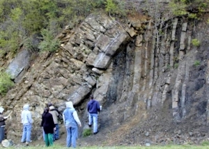
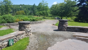
The location is one of the great geological tourist traps of our part of the country. Between now and early autumn scores of these visiting vans will appear here. The outcrops stretch for a mile or so along Rte. 23, but there is one location which is even better than all the rest. That site is the exit ramp where drivers leave Rte. 23 and get onto Rte. 145 west. They may be headed for Leeds, but they are passing some very good geology.
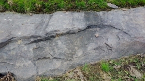
The location displays what geologists call an angular unconformity. If you stop there you will see one set of stratified rocks dipping steeply to the right. These strata are alternating horizons of sandstone and black shale. They make up a very small part of what is called the Normanskill Formation. That rock unit dates back to a time called the Ordovician and that makes them about 450 million years old. These strata were deposited in what was probably some very deep, marine waters, but that is not our story today.
Above the right-dipping strata are some left-dipping beds. Left and right, these contrasting inclinations form the “angular” part of an angular unconformity. The overlying strata are called the beds of the Rondout Formation. That unit is Silurian in age and that makes it merely about 420 million years old. That leaves about 30 million years missing and that is the “unconformity” part of our angular unconformity.
The sedimentary rocks of the Rondout are called dolomites. Dolomite is a calcium/magnesium carbonate. It used to be a different rock, something commonly known as limestone. That’s important as limestone only forms in a tropical climate. These sediments accumulated on an ancient mudflat, at the edge of an ancient tropical sea. The sediments made up the upper reaches of the high tide level, we call that a “super-tidal” setting. The ocean waters only reached this high up at the highest of tides. You would have to travel to the Persian Gulf to see something like this today.
The Rondout is important to geologists as it forms the first and oldest unit of the Helderberg Sea. This is a thick sequence of limestone that makes up the Helderberg Escarpment which looms as a great ridge above Albany. The Helderberg strata make up a lot of the bedrock in this area and so geologists pay a great deal of attention to it.
At the Rte. 23 outcrop, the Rondout is capped by some badly distorted strata. They were deposited as flat sheets but subsequently they came to be deformed as great crustal stresses folded them up. You can easily see this at the outcrop. The top of the folded sequence marks what many geologists call the very end of the Silurian time period. Above this horizon is the very first stratum of the next time unit, the Devonian, dating back to about 419 million years ago. This is a very important horizon as the Devonian is the most important unit of time in the entire Catskill region. Every bit of bedrock from here to Syracuse and beyond is Devonian. That’s a lot of rock and it all started right here. This horizon of rock takes us back to the dawn of the Devonian and the very dawn of the Catskills themselves. That makes it important. But, before the Devonian, there was the Silurian.
Sunrise, July 14, 419,632,751 BC – The air is absolutely quiet. Not the slightest of breeze can be felt. The landscape is similarly still. All around us to the east is a monotonous flatness. It’s not that the land is smooth; it’s a very rough mudflat. Every few feet there is a low tilted ledge of rock just poking above the surface. These ledges vary in thickness; some are just a few inches thick, while others can be a few feet thick. Each ledge is composed of sandstone; each has a bleached creamy yellow appearance. Each is broken up by fractures that pass perpendicular to the rest of the rock. The ledges all seem to be broken up into rough cubes.
In between each set of ledges is a small “valley;” all of these are filled with a litter of dark gray pebbles, mixed with a darker, almost black, earth. Here and there, some very small puddles can be seen in the valleys. The edge of each of these is rimmed with a white substance that appears to be salt. These are, indeed, saltwater pools, and they have been evaporating in recent times.
This is the most dead-looking of landscapes. There are no plants here, not a blade of grass nor even a lowly weed. There are no insects on the ground, nor are there birds in the sky. A careful check of the “soils” would not even reveal any worms.
And it is, of course, absolutely quiet. There is no wind and there are no animals to break the silence. It is a silence that is almost impossible for us to imagine for we are visitors from a noisy world.
But this actually is our world, and it’s a very familiar part of our world. Someday this very location will be the intersection of Routes 23 and 145; this will be the exact place were an exit lane connects the two highways. People will call this the town of Leeds. But, at the time of our visit there is no sound of traffic. This is not the noisy world of today, but the almost silent world of the late Silurian time.
But we are time travelers and we have our left foot in the Silurian and our right one is in the modern world. We look to our left and see a Silurian sunrise, to our right the highway traffic of Rt. 23 zips by.
But our interest and presence in the modern world fades; it is the Silurian vision that captivates our mind’s eyes. There and then, on the distant eastern horizon, the sun is about to rise. A gray light first appeared, and then slowly turned red, and now it is brightening with ambitions of an intense yellow. The exact moment of sunrise is always magic. The brilliance of the sun just creases the horizon and, quickly, the rest of the great orb ascends into its rightful position in the sky. The movement is smooth and surprisingly quick. It is the only time of the day when you can really sense the movement of our great nearby star.
For almost four and one half billion years the sunrises have been appearing on this horizon, but the sun does not show its age. This Silurian time period has been a fine era for sunrises. What with all the flatness of the landscape extending off to the east, nothing ever gets in the way of a view of the rising sun. And now the sun is gaining altitude and its light shines across our flat lands to far behind us.
We turn and gaze westwards and there, before us, is a very broad and very smooth sandy mudflat. On the distant western horizon, the disk of a gorgeous full moon is just setting. Full moons are like vampires; they do not like to be out during the day. They always set just as the sun comes up.
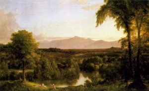
And way out there, where the moon is setting, is the flat horizon of a distant ocean. It is nothing like the great Atlantic of today. There is no chop to the water, not even waves lap up against this shore. But it is a sizable body of water and it will, someday, be called the Helderberg Sea. It is, as far as we can observe, a very shallow water ocean. Today, with no wind, there are no waves or substantial currents, and its clear, aqua-colored waters lie still on the horizon.
Our nearby mudflat is composed of white, fine-grained limy sand and its smooth surface almost glistens. It was recently soaked under a very high tide, but those waters are receding rapidly. Mudflats should be dotted with snails, slowly meandering about, but this one is not. It seems to be just as dead as the flat landscape to our east.
With the rising of the sun, a little breeze is at last generated. It is a very warm wind; these are the tropics and the temperature will be very hot later in the day. It was like this yesterday and it will be like this tomorrow. Change comes very slowly in the Silurian.

Contact the authors at randjtitus@prodigy.net. Join their facebook page The Catskill Geologist.”

The Ice Age at the Catskill Arboretum 6-20-19

in Uncategorized by

The Ice Age at the Mountain Top Arboretum
On the Rocks

Woodstock Times Dec. 2018
Robert and Johanna Titus

While we spend a lot of time out looking at our region’s geology, we also make real efforts to be active with many of our local Catskills civic groups, including of course the Woodstock Land Conservancy. Another of those groups is the Mountain Top Arboretum. We have spoken there several times. Have you been there? It’s just north of Tannersville. The Arboretum is home to a collection of mostly local and native tree species. Having been founded in 1977, those trees have not had time to get to be very tall, but they are coming along.
. Actually not all of the trees up there are local, and some not only came from far away, but they date back to much earlier times in Earth history. Have you ever seen a Metasequoia? Its common name is the “Dawn Redwood.” The genus evolved about a hundred million years ago, during the Cretaceous time period and was ancestral to the giant trees of today’s California. Well, a few of them have been planted at the Arboretum. They are worth the trip all by themselves.
But, curiously, trees are not the topic of today’s article; this is, after all, a geology column. Recently, the Arboretum asked us to conduct a survey of the geological history of their property. We do that sort of thing frequently. We went up there and poked around. What we found is some very good ice age history. And to make it better, much of this ice age history is packed into just a quarter acre of land right next to the parking lot.
Let’s take you up there. Drive through Palenville and Tannersville on Rte. 23A; then turn right (north) on 23C. You are definitely on the proverbial right side of the tracks and you will see some very nice summer homes along the way. When you get to the Arboretum, you will find that parking lot right next to the highway. Just across the driveway is a low exposure of Devonian aged sandstone.
This is located right at the gate to what is called the West Meadow. As soon as we reached the exposed bedrock we saw evidence of an ice age history here. We looked down and saw what is called a glacially scoured surface. The rock here was ground into a smooth surface, mostly by sand carried by a passing glacier. The weight of the ice had pressed the sand into the bedrock, just like sandpaper. That’s why it is so smooth.

There was more, that glacier had carried cobbles and they too had been ground into the bedrock. That left scratches behind. All of them had nearly perfect north-to-south orientations; this recorded the directions of the glacier’s flow. Geologists call such scratches “glacial striations.” You will have no trouble finding them.
Then we noticed something else. Strata of sandstone had been broken loose by the passing ice. The advancing ice had formed a bond to the rock and, as the ice moved south, it yanked or plucked rock loose. This left low ledges of sandstone facing due south. See our second photo.

After visiting the glacially scoured landscapes of the West Meadow, you might go back to the parking lot and get a map of the Arboretum trails. Return and head east on Maude Adams Road. You will pass the East Meadow on the left and then reach the Hemlock Trail. That trail will take you south through what is called the Spruce Glen, all of this is Arboretum property. Look left and right; you are passing through a glaciated landscape. Here there is no bare bedrock exposed, instead this was a location where retreating glaciers left behind hummocky heaps of earth as they were melting. This records a time of global warming.
We are geologists; we are never entirely in the present when we are out exploring; we always let our mind’s eyes take us into the past. We were walking south on the Hemlock Trail and then turned around and looked north. In front of us we saw the edge of a melting sheet of ice. It was about 14,000 years ago. This was very late in the Ice Age and we had landed here on one of those increasingly common warm days. Before us, the disintegrating glacier rose up and presented us with an image of vast volumes of meltwater pouring out of large crevasses all across its front. Streams flowed past us, left and right.
But there was more; those heaps of earth lay all about, all of them left behind by the melting ice. There was no vegetation. Life had been following the melting glaciers and heading north, but it had not yet returned to the Arboretum grounds. Many cobbles and large boulders lay all about us. Otherwise, it was a bleak, barren and inhospitable landscape. In the distant future geologists would call this sort of thing a recessional moraine. But, unlike those other future geologists, we did not have to imagine it; we were privileged to witness it for ourselves.
We turned south again and continued along what would eventually be the Hemlock Trail–many thousands of years after the Ice Age had ended. Soon we spied a pond. The shallow valley here had been blocked and dammed by some more of that moraine material. We walked down to its shore and gazed into its black waters. Then, in a dizzying flash, we were transported back to our own time, the spring of 2018. We were standing at the very end of the Hemlock Trail, in front of us was a dock that led out onto what is called today “the Hidden Marsh.” There was no longer a pond here; it had filled with the sediments and the vegetation of that marsh.

We had not just been hikers on this geologic trek; our travels had taken us through what scientists call “time and space.” You can go up there and take this trip yourself. We think you will enjoy it.
==================================================================
Contact the authors at randjtitus@prodigy.com. Join their facebook page “The Catskill Geologist.” Read their blogs at “thecatskillgeologist.com.”

The Mountain House ledge June 13, 2019

in Uncategorized by

Visions of a Hudson Valley geological past: “The Mountain House Ledge.”
Visit the Mountain House ledge and explore its geological past.
Updated by Robert and Johanna Titus

Certainly one of the most historic sites in all the Catskills is the Mountain House ledge at North/South Lake Campground. We are betting that most of you have been there. It’s a grand, broad shelf of sandstone, jutting out 2,000 feet above the floor of the Hudson Valley. It’s claimed that you can view some 70 miles of that valley from this site. It is, of course, the very place chosen for the building of the Catskill Mountain House Hotel, back in the 1820’s. That was the grandest of the grand hotels of the Catskills during our region’s most fashionable era. The hotel attracted a Gilded Age aristocracy; a Who’s Who of the American elite vacationed there. But something spiritual happened here too. America came to love nature at this location. It was here that the Hudson Valley School of art was born, when Thomas Cole spent a summer sketching the scenery. Almost equally distinguished was the poetry and prose that was inspired by this “sublime” wilderness landscape.


There is no way to overestimate the historical heritage of these few acres of land. The whole culture that we equate with the word Catskills had its birth at the Mountain House. And the hotel had its birth on this scenic ledge. It is one of our favorite places. We frequently go there and just sit upon the ledge’s rocks. We touch the sandstone and look around. All that lies above the ground, above those rocks, belongs to history. Here historians such as Roland Van Zandt and Alf Evers prevail. They explored the past at this site and recorded its many influences on our modern culture.
But, we touch those rocks again. Everything below the ground belongs to us! All around is the historical heritage of modern Catskills culture but below is a geological past that reaches back hundreds of millions of years. Nearly four miles of sedimentary rock lies beneath us – right here. And, down there, every stratum of rock has its own history, from its own time.
We touch this ledge and contemplate its petrified sand. It accumulated on the floor of a river channel. That was during the Devonian time period, about 380 million years ago. A river flowed by, right here, and then it disappeared off to the west. We gaze west and then turn around and look, more intently, eastward hoping to see where that stream and its sand came from. But . . . there’s nothing there but the great emptiness of the valley.
Suddenly, we are time travelers; around us it is the Devonian time period. We are just above the waters in the middle of that stream, looking east. To our left and right are the river’s low banks. Rising above them are Devonian trees, at least they must be trees; they are so exotic, so strange in appearance. Frail looking trunks rise 25 feet above the banks. There are no branches, not until the very top is there even any foliage. All this defies all efforts at description. There are no leaves, just things that might be called fronds. But even that term does not suffice. These are among the most primitive “trees” known to science. They represent evolution’s earliest efforts at the very concept of a forest, and Devonian evolution has not yet become very good at that. If these trees defy description, it’s because nothing like them grows today.
We turn and look east. In the distance a mighty mountain range towers above that horizon. We quickly realize that the Taconic and Berkshires of today are but the roots of this ancient mountain range. Their middle slopes are gun metal blue and cut by many enormous ravines. Above the blue is a horizontal white snow line. High above that are the white peaks of this enormous range.
Our journey into the past is a brief one. Soon we sit again upon the Mountain House ledge and see our modern landscape. We have beheld its geological heritage.
Reach the authors at randjtitus@prodigy.com. Join their facebook page “The Catskill Geologist.”

Visions of the past – Catskill Creek June 6, 2019

in Uncategorized by

Visions of an Art Trail past – Catskill Creek
On The Rocks
Jan. 30, 2013
Robert and Johanna Titus

We have been traveling the Hudson River Art Trail, seeing the landscapes that so inspired the great American artists of the 19th Century. But ours have not been the journeys of art historians, but those of geologists. We are privileged to see what the artists could not; we can look into the distant past. Last time we visited Frederic Church’s Persian Revival house Olana and we saw the ice age history of that site. In this journey we visit what may have been Thomas Cole’s favorite scene: that is the view of Catskill Creek from Jefferson Heights just west of the Village of Catskill.
That location was just across Catskill Creek from Cole’s home. He frequently hiked there and composed views. In the foreground there was a great bend in the creek as it flowed by below. That was scenic enough, but in the distance it all got better. Out there was the Catskill Front, the fabled Wall of Manitou, lying on the western horizon. In a recess on that distant horizon, but still close enough to be seen, were the lower stretches of Kaaterskill Clove.


Cole seems to have done a dozen or so paintings at this location. Like any good artist he experimented. He tried out the scene at different times of the day and during different seasons of the year. His art can be called luminism; he liked to place the sun in the far distance and paint its light shining down and across the landscape. He could vary the sun’s color with the time of the day, saving deep reds and oranges for late afternoon. He returned to the site as the years went by, and painted changes that had occurred there. Much to his dismay he saw a railroad line put in. He lamented the encroachment of industry on what had been a purely pastoral image. Landscape artists do not celebrate industrial development.
As the generations have passed since Cole’s time, a different sort of development came along: the forests returned. At least the trees did. They grew up and blocked Cole’s cherished view. When we first searched for it, we could not find it; it was hidden by the foliage. When the Art Trail was developed that posed a problem. The trail guide leads visitors to a nearby restaurant site, but you just cannot obtain a good view there. Thomas Cole’s grand scene seemed to have been lost to the very Nature he painted so well.
But, very recently, that all changed. At the top of the hill, at Jefferson Heights, a new sidewalk was installed. You can walk it and look to the west and, especially during the winter, you can see Cole’s bend in the river, right in front of you, and in the distance, the Catskills are out there too. It’s not as clear a view as Cole had, but it’s pretty good. We were thrilled when we first found this. We were sharing a moment with Thomas Cole and the whole Hudson River School of Art.
But we also saw this view as Cole couldn’t; we saw it about 15,000 years ago, at the close of the Ice Age. As geologists we get to pick exactly what times we go back to and visit. With our mind’s eyes we can witness those moments. And, for this journey, we picked a very good moment to visit. We wanted to see the Cole view as it was when the ice was melting. But we also wanted to see that view on the day when the melting reached its all-time peak. There had to have been a day and an hour when a warming climate was melting an absolute maximum of ice. That was the very moment when more water was cascading down Catskill and Kaaterskill Creeks than ever had before or ever would again. The channels and valleys of these streams strained to contain the flow – and failed.
We stood upon the same Jefferson Heights site, but for us it was that exact moment, 15,000 years ago. Below us, a vastness of water was pouring down the creek. It ignored the bend in the river as its flow rose and swelled up to overwhelm the whole valley. What we saw was a horizontal waterfall. The water presented a mixed image, contrasting its own gray brown colors with whitecap whites. This torrent swirled, and foamed, and thundered as it rushed by. The power of the flow was frightening; the sound was deafening. This was the full fury of Nature, displayed in a riotous image.
We looked up, all the way beyond to distant Kaaterskill Creek. Even in our mind’s eyes we could not travel that far. It must have been much worse out there, with a still greater flow of water coming down that steep canyon. We strained to see and were frustrated that we could not. We debated it and finally convinced ourselves that we were seeing a large rainbow rising above the mouth of the Clove. It was too distant foe us to be sure. We were awed by all that we beheld and we fully understood that we were seeing history in the making. What we were watching was nothing less than the great rising crescendo of an ending Ice Age.
Nobody ever painted this scene.
Contact the authors at randjtitus@prodigy.net. Join their facebook page “The Catskill Geologist.”

Go to Top