"I will never kick a rock"

Monthly archive

July 2018

Rocks with sole July 26, 2018

in Uncategorized by

Rocks with Sole
The Woodstock Times
A long time ago
Updated by Robert and Johanna Titus

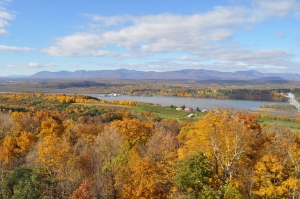
The Austin Glen Formation is not all that impressive a rock to look at. It’s made up of alternating strata of gray sandstone and black shale. But in many ways, it is one of the most awe-inspiring rock units in the area. It makes up much of the bedrock on the east side of the Hudson River. Travel across the Kingston-Rhinebeck Bridge and it makes up the first outcroppings of rock you will see. These are the low cliffs on either side of Rt. 199. We made the trip recently and took a good look at these outcrops. About 30 paces east of the beginning of the west-bound lane’s exposure we found a remarkable sedimentary structure: One overhanging stratum of rock displayed a crenulated surface. We recognized the form as a type of “sole mark” and it conjured up quite an image from the past.
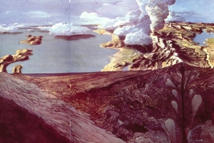
The sands and muds of the Austin Glen were deposited in some of the deepest waters that make up ocean basins. There is a wonderful word, “abyss,” used to describe great depths in the sea. The abyssal plain is a great vast flat sea floor, about two miles down. But we are talking about something even deeper. We are speaking of a sea floor zone called the hadal zone, that’s a great deep trench at the bottom of the sea and it can be several tens of thousands of feet deep. Today’s Marianas Trench is the best such example we can go see. It is 36,000 feet deep, an incredible depth. We don’t think that the Austin Glen was quite that deep, but who knows for sure.
Not only is a marine trench of this sort deep, but it is also very steep-sloped and that gets us to today’s story. You see, the shales of the Austin Glen formed originally as black muds. It’s typical for such great depths to accumulate muds; the fine clay particles settle to the deep-sea floor and make up the muds. But the sands are different; sands are usually shallow water deposits. Obviously, the sandstones of the Austin Glen weren’t shallow water deposits so how did they get there?
The answer it that the sands were once part of something called turbidity currents. These are very fast-moving currents of dirty (turbid) water that rushed downslope at speeds of up to 50 mph. More likely than not, an ancient earthquake struck and displaced a large amount of shallow water, sandy sediment. Billowing masses were thrown up into suspension by the quake and then they began to flow downhill under the influence of gravity, soon accelerating to their rapid pace. A turbidity current is one of those very powerful forces of nature. Fortunately, there are few animals that stand in the way and few deaths result. There is some destruction, but only in the form of rapid erosion of sediments crossed by the current.


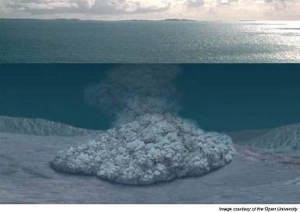
At the bottom of the slope the turbidity currents slow down but, still moving rapidly, they spread out across the soft muds and deposits their sandy sediments. The sudden deposition of sandy sediment upon soft muds has an interesting effect. As the sand spreads out across the sea floor, it presses into the soft muds. The results are the crenulated surfaces we described earlier. They are called sole marks. There are a number of different types of sole marks and, technically, these ones are called “squamiform load casts.” Let’s not get too concerned with the exact terminology and instead try to appreciate the aesthetics of these structures.

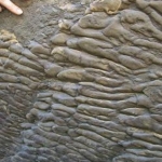
They are rather remarkable in the details of their sculpturing and we have trouble finding just the right adjectives for them. Take a look at our illustration and you will get a good impression of them. These soles are common throughout the Austin Glen Formation and, once you have an eye for them, you may be able to find others. We origins: underwater avalanches, triggered by great earthquakes; it’s quite a scenario and very typical of what we find when we know what to look for in the rocks.
================================================================
Contact the authors at randjtitus@prodigy.net. Join their facebook page “The Catskill Geologist.”

A new trail at Kaaterskill Falls July 19, 2018

in Uncategorized by

Tub thumping at Kaaterskill Falls
On the Rocks
The Woodstock Times
April 14, 2015
Robert and Johanna Titus

Have you been to the new trails at Kaaterskill Falls? We lobbied for this sort of thing for many years. The DEC seems to have been influenced, in part, by this column in the Woodstock Times.

The year 2014 was a difficult one at Kaaterskill Falls. That summer two people fell to their deaths. It’s a dangerous place; you only have to be careless for a second or two and then the worst can happen. Naturally, everyone involved is quite concerned about the upcoming summer season. We wish these things did not happen, but they do. And there is so little that you can do to mitigate this sort of thing. They have put some new fences up, but they are unlikely to deter people from going into dangerous areas. Some better communications are now available for first responders, and we understand that the site is better prepared to get helicopters in and out of it.
Still, it just takes a second or two for the worst to happen,
But we are concerned about other problems at Kaaterskill Falls, and those are problems that may actually have solutions. Our first concern is the ongoing erosion of the slopes just to the right (east) of the falls. It has been about two centuries now, that people have been coming here in ever increasing numbers. It used to be that the marked Yellow Trail ascended the slope to the right of the falls and people climbed up to the top of the falls that way.

But the ground is soft there and, especially when it is wet, the results of climbing are to mobilize the earth. There is no hope for vegetation to take hold here; plants are quickly trodden into the ground. When it rains, the bare earth is likely to slide downhill, just a bit: just a bit today, and just a bit tomorrow, and just a bit next week. You get the picture. The slopes have been eroding for all those two centuries.
Years ago, the Yellow Trail, above the base of the falls, came to be closed. That probably has helped a little bit, but just a little bit. People still climb up those slopes: we confess; we are among them. It’s not likely that this will stop. Late, last summer, those new fences were put in, but it is hardly likely that these will even slow people down. We posted a photo of one new fence on our Facebook page and the responses were uniformly sarcastic.
So, if this is not working, then what should be done? Our solution, and we have been arguing this for 20 years, is that a staircase should be built. That’s certainly not an unprecedented idea. When William Henry Bartlett sketched at Kaaterskill Falls during the 1830’s, his picture showed a staircase from the bottom to the top of the falls.


Detail from Bartlett print of Kaaterskill Falls. See staircase to right.

But during the last century, this property came to be owned by New York State, and thus part of the Catskill Park. If we understand it properly, park land should not have artificial constructions on it. This land is supposed to be pristine and natural. A staircase would be unnatural, a violation of what is intended. The irony is, of course, that, without a staircase, people do far more harm.
So those “pristine” slopes have been slowly and steadily deteriorating for centuries now: with more centuries to come? We hope not. If we are looking for precedents, we do not just have to visit the 1830’s; we can look at a good example today. Have you ever been to Mine Kill Falls? Take Rte. 30 north from Grand Gorge and watch for signs that announce the presence of the falls. There is an ample parking lot and, just below that, you can begin descending a nice dirt trail into the Mine Kill Gorge. The trail will take you all the way to the bottom of the falls. Your boots will do little damage here; the slope is so gentle that you will not trigger any significant erosion.


But, there is another trail. Its left fork takes you to a staircase and that staircase takes you to a fine view of the upper Mine Kill Falls. Then there is a right branch; its staircase takes you to a view of the lower falls and the canyon below it. It is a most remarkably picturesque location. And we don’t think you will find that the scenery is harmed in any way by the staircases. You will not likely find this to be some sort of environmental abomination.
The steps get people to the upper falls safely and easily. And there is absolutely no erosion going on below the stairs, nor will there ever be any. It is a nice, environmentally sound, solution to a serious problem. Visit Mine Kill and see for yourself. Then imagine some equivalent installations at Kaaterskill Falls.
But there is more, there is another problem that we wish to help solve. The two of us belong to the Mountain Cloves Scenic Byways Committee. We are hoping to promote greater eco-tourism in our picturesque eastern Catskills. We need a trail system that smoothly transports hikers from below Kaaterskill Falls, past the falls, and on to the Blue Trail that leads to the north rim of Kaaterskill Clove. In short, we want a well-planned trail system that promotes green tourism.
We don’t have that now. Today, you can take the Yellow Trail to the base of Kaaterskill Falls and then you are supposed to turn around and go back. Who on earth would want to do that? Our proposed staircase, we hope, would lead on, above the falls, to join the greater trail system. It would be a great lure for tourism in our area. We need it.
This is Greene County; our tourist industry has long been deeply depressed. Greene County is a landscape of lost hotels, empty motels, and long forgotten boarding houses. This, the onetime home of the Catskill Mountain House Hotel, now has very few overnight rooms and still fewer people looking for them. We need help and, just maybe, a more thoughtful trail system would be a step in the right direction. That all hinges on a staircase being installed at Kaaterskill Falls.
We don’t do a lot of tub thumping at On the Rocks, but we think this is worth the effort.
==================================================================
Contact the authors at randjtitus@prodigy.net. Join their Facebook page “The Catskill Geologist”

Lost continent of Atlantis 6-12-18

in Uncategorized by

Living on Atlantis
Stories in Stone
The Columbia County Independent
December 2005
Updated by Robert and Johanna Titus – July 12, 2018

It was 2,300 years ago that Plato wrote of a great island, “larger than Libya and Asia taken together.” His island was the fabled Atlantis and it lay out in middle of the Atlantic Ocean, beyond the Straits of Gibraltar. The story went on: fully 9,000 years before Plato’s time, Atlantis was a great city state which controlled an empire extending as far east as Egypt and Italy. After fighting and losing a war with the Athenians, Atlantis was consumed by a day and a half of earthquakes and floods. The whole land mass sank into the ocean and it has been lost ever since.
It’s a wonderful story and just the type that that we scientists love to debunk. But the word debunk implies ridicule, and when you ridicule a popular myth, you run the risk of appearing arrogant. Now, believe us, arrogance is not exactly unheard of in science, so let’s take a careful look at the story of Atlantis. We will find, as is so often the case, the true story is a lot better than the myth.
You can start by traveling to west of the Hudson River and gazing back eastward from any prominent high point, preferably the top of the Catskill Front. A lot of geologists have done this. They are looking at Columbia County and the profile of the Taconics, but nearly all have pondered the same question: Where did all this rock come from? Beneath them, the Catskill Front is made of 17,000 feet of sandstone shale and limestone. That’s only a small part of what is sometimes called the “Appalachian sequence.” The whole sequence consists of sedimentary rocks about 40,000 thousand feet or so thick. It wasn’t always rock, it was once all sediment. Sediment has to come from somewhere and 40,000 feet of it has to come from somewhere—and somewhere big, so you can appreciate the geological curiosity.
In the 1840’s James Hall, the great Albany geologist, got very interested in finding where all those sediments had come from. He traced them all across North America and soon convinced himself that the thick Appalachian deposits always thinned to the west. It must be, he thought, that if the sediments thinned to the west, then they must have come from a source in the east. Now James Hall had no interests in the myth of Atlantis, but other geologists wondered about that sourceland. Was this the real Atlantis?
In the late 19th century, Charles Callaway calculated the total volume of sediment that made up the Appalachian sequence. From this he judged that there must have once been a sourceland out in the North Atlantic. He estimated it to be about the size of Australia. Callaway thought that the weathering and erosion of this sourceland provided the sediments of the Appalachian sequence and also similar rocks in Europe. Callaway thought that he had come up with the scientific discovery of an ancient lost continent–a real one! He called it “Old Atlantis.” Old indeed, Callaway’s continent was about 400 million years older than Plato’s one.


                                               Callaway’s cross section of “old Atlantis” and its sedimentary rocks.

Callaway’s idea remained popular into the 20th century, but as science progressed, it didn’t hold up all that well. Oceanographers were learning more and more about the floor of the North Atlantic. Surely, they reckoned, if there had once been and Atlantis out there, then some remnant would still remain, but none was ever found.
The solution to the source land problem came in the late 1960’s and it was a terrific story, much greater than the old myth. Continents and oceans, it turned out, were not eternal. Once there had been no Atlantic Ocean at all, neither was there a North America or Europe. Instead there were great land masses, ancestral to the ones that we are familiar with today. Back then, an ancestral Europe was drifting westward and actively colliding with an earlier form of North America. As the two crushed together a great mountain range was thrust up all along the collision zone. Such things do happen and can even be seen today. India is colliding with Asia and the Himalayas are the product of that collision. Our Taconics and Berkshires are part of the 400 million year old ancestral Appalachian system. At their peak they were called the Acadian Mountains and they, not Atlantis, provided the sediments we see today in places like the Catskills.
So the Atlantis of Plato’s myth never did exist. But when we debunk his story, it’s not arrogance, but confidence that science can provide a better story which motivates us. Our story tells of moving and colliding continents. The story speaks of once towering mountain ranges which are no more. It’s a great yarn and one of the most important scientific discoveries of the last century. And to us, the best is that the story comes from the stones.
So find the time someday to take a hike up to the top of the Catskill Front and gaze east. Find the Taconics and Berkshires on the distant horizon. That’s Columbia County below them; it’s all “Atlantis!” Adds something to the view, doesn’t it?

Contact the authors at randjtituss@prodigy.net. Join their facebook page “The Catskill Geologist.”

The Abyss 7-5-18

in Uncategorized by

The Abyss

A shortened version of a Kaatskill Life article from 2002

Revised by Robert and Johanna Titus


One of the great tourist attractions of our area is Olana, the one-time home of painter Frederic Church. We stood on the bank in front of the south-facing porch of the old mansion and gazed at its fine view of the Hudson Valley and Catskill Mountain. This is one of the great vantage points from which to see the Catskills. There are days when the atmospheric conditions are just right and the mountains seem to reach out to you. It’s not just a view; this is also a genuine work of art. Frederic Church intended the porch should have this vista; it is, among many others, one of his “planned views.” For thirty year he was able to enjoy the scene and we envy him that.

But as geologists, we are privileged to see some other views at Olana. On that wonderful site our minds drifted back into deep time. We were at the bottom of the oceanic abyss that was once here. The waters were tens of thousands of feet deep, cold and black but, more than anything else, they were still and silent. This was a dead seafloor. Nothing crawled across the sea floor and nothing swam in the waters. We scooped up some of the mud; it was soft and sticky. It was foul with the remains of dead microbes that constantly rained in from above.

With time the submarine avalanches came. Geologists call them turbidity currents. The stillness was abruptly interrupted as the sea floor was jolted by seismic shocks. An earthquake had struck. Shortly thereafter great masses of sediment began tumbling down the steep slopes. For long minutes there was the rush of dirty water into the abyss. The torrent boiled as murky clouds billowed upwards all around us. Then the current slowed and gradually the water cleared. The Olana sea floor returned to its silent dead, stillness.

Our mind’s eyes rose through tens of thousand of feet of quiet water until they reached the surface of the sea. We gazed eastward and saw dense black clouds rising above the horizon. The blackness drifted our way and soon it rained volcanic dust into the water all around. Then we looked back eastward again, and now a rising landmass had replaced the black clouds on the horizon. The stark profile of volcanic mountains defined this new horizon

The passage of time accelerated. As we watched, this landmass grew taller and its shores swelled out toward us. We were soon lifted out of the sea by the rising gray crust. Occasional, the earth beneath us shook with powerful quakes as the land rose higher and higher. Eventually, we found our imaginary selves high atop a still rising Taconic Mountain range. To the north and south, volcanoes continued erupting in violent spasms. Below, to the west, what was left of that deep sea retreated away from the rising mountains.

There should have been a great deal of green in this image but there was none. This was a fine range of mountains, but it was a dead landscape that had replaced a dead seafloor. We were in the Late Ordovician time period, about 450 million years ago, and life, especially plants, had not yet managed to colonize the lands. All around us was a bleak, blue-gray landscape. There were not even proper soils, just a litter of gray gravel lying upon bare rocks. Only the dry channels of gullies and ravines broke the monotony of the desolation.

We realized that we had come to the very spot where, 450 million year later Frederic Church would stand. But we were not seeing what he would see. No, below us and stretching off to the west, a large river delta had formed adjacent to the rising Taconic Mountains. A complex of murky streams crossed the dark gray of that delta. Farther away we could see the retreating waters of the sea. It was bleak and lifeless vista, but there was grandeur in this, Olana’s great unplanned. view.

Contact the authors at randjtitus@prodigy.net. Join their facebook page “The Catskill Geologist.”


Go to Top