"I will never kick a rock"

Monthly archive

April 2018

The Glaciers of Hunter Mountain April 25, 2018

in Uncategorized by

HUNTER MOUNTAIN BESIEGED . . . AGAIN

On The Rocks

August 29, 1996 1996

Updated by Robert and Johanna Titus


They say that it is human nature that the end of one conflict often bears the seeds of the next. This somber observation may be the case with Hunter Mountain, the second highest mountain of the Catskills. Recently (That was in1996) there was a proposal to alter the New York State constitution in order to allow the development of about 3,000 acres at the summit of Hunter Mountain. This would have allowed the expansion of the Hunter ski complex into something comparable to what we now see in Vermont. Currently skiing on Hunter is confined to the “Colonels Chair” which lies on the slopes of Shanty Hollow. If the proposal had gone through (It didn’t), skiing would have been expanded to Taylor Hollow to the northeast and Becker Hollow to the east. These three hollows have origins that date back to the last time the mountain was besieged. That was during the ice age when the proposed ski bowls of Hunter were occupied, not by skiers, but by Alpine glaciers.

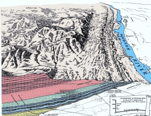
Few people realize the role that glaciers played in making our Catskill landscapes. The story takes us back to a chapter in glacial history described as the Wisconsin glaciation. Catskill glacial history is complex, but there were two very different phases. First there was a time when a great, half mile thick sheet of ice swept across our mountains. The Catskills then resembled the high ice plains of today’s Antarctica. By 16,000 years ago, however, the Catskills had escaped the worst grip of this phase. The great thick ice sheet was gone, but all was not over yet. Glaciers were still found in the shaded valleys, and also in the high mountain niches that were giving birth to a number of Alpine glaciers. If you are familiar with the images of the Swiss Alps of today then you know that high up in the Alps, large glaciers form in pre-existing hollows. These are nourished by snowfall and, with cold conditions, these picturesque Alpine glaciers descend the slopes and flow into the valleys below. That was the case with Hunter Mountain.

As time went by these glaciers modified their own Alpine niches. Glacial ice forms a sticky bond with the rock beneath it, and as the ice moves, it plucks loose large amounts of this rock. Alpine ice is thus a very effective agent of erosion. Given enough time, this expanded the niches and enlarged them into beautiful, bowl-shaped features called “cirques.”

There are a lot of cirques in the Catskills, but few of them are as well developed as those of the Alps. This phase of glaciation was too short for Swiss-like landscape to develop. Warmer conditions returned, and the Alpine glaciers melted. Nevertheless Hunter Mountain displays some of the best cirque landscape seen in the Catskills. In addition to the three hollows we mentioned earlier, there are the hollows at Myrtle Brook, Diamond Notch, West Kill and Hunter Brook. All seem to have once harbored glaciers. Some of these can be seen from Rte. 23A, below.


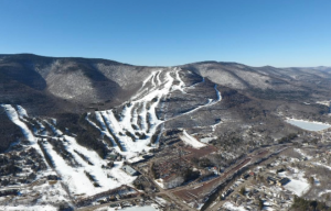
                                                                          Cirques, left and right of the ski slopes.


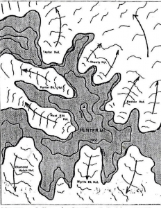
                                                         A map of Hunter Mt. showing its seven Alpine glaciers.  


The effects of glaciation persist long after the ice is gone. These bowls initiate what we call “watersheds.” The hollows are ideally suited for the purposes of gathering rainwater and passing it on to the river systems below. Of the seven hollows which surround Hunter Mountain, five of them feed water into the Schoharie Creek watershed. Only one of these five, Shanty Hollow, is currently a ski slope, but Taylor and Becker Hollows were planned to be added. Watershed protection was one of the most important reasons why the State purchased the land in the first place, and was one of the primary reasons for opposition to the ski slope expansion.

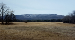
You can see some of this Alpine landscape. From West Kill Valley take the Devil’s Path up the western slope of Hunter Mountain. There is a fine ledge at the top of the trail. That is the top of a cirque. The cliff below drops off into an Alpine glacier’s niche. Look west into the valley of West Kill. The beautiful U-shaped valley you see is the product of the glacier’s erosion as it flowed down the valley.


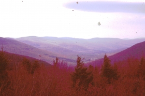
                                                                             View of U-shaped West Kill Valley

Contact the author’s at randjtitus@prodigy.net. Join their facebook page “The Catskill Geologist.”


Yellow alert – a coming landslide? April 18, 2018

in Uncategorized by

Yellow Alert?

Stories in Stone

Columbia County Independent

May 13, 2005

Updated by Robert and Johanna Titus


We have, recently, had a growing sense that something has been going on geologically, here in our upper Hudson Valley. We think a pattern has been developing. Scientists notice patterns and we seek to understand them. We had better explain.

We commonly drive past the Gilboa Reservoir. Lately, the water has been pouring over the top of the dam. That’s unusual; most of the time the reservoir is well below the dam’s top, sometimes the reservoir is nearly empty. It’s easy to say that it has just rained a lot recently, but we wonder.

Over the last few years there have been a number of damaging slumps in the upper Hudson Valley. First came the Delmar slump, south of Albany, which put a major road out of commission for quite some time. It had been built on the muddy sediments of an old ice age lake, Glacial Lake Albany. The sediments simply gave way and slid into Normans Kill. Well, these things happen, or so we thought at the time.

But then, last year there was another slump, this one in Schenectady. The edge of an old Lake Albany delta slid downhill and that doomed six homes. Soon we had a small slide just a mile from the Titus family home in Freehold. Again, this spring, we have seen still another nearby bank give way and now it seems to be oozing water. That’s too close for comfort.

Slumps are an ongoing problem in the Hudson Valley and we have written about them before, but there seem to be a lot of them lately. Two weeks ago there was a new slump in Amsterdam. This one also seems to have involved the sediments of another ice age lake delta. That’s alarming; why are these events coming at such a rapid rate?

But then it got even worse. we began receiving E-mails from people in Valatie, complaining about flooding basements. Three houses on New Street have been experiencing serious problems for weeks. Basements flood; that’s their job, but some of these folks claim that they have never seen the likes of this even after decades of residence and they are worried.

All this may just be coincidence and might mean next to nothing. Or, all this may just indicate that we have had a lot of rain lately. That would explain this year’s problems, but it would not tie in the events of recent years.

In the end, it seemed to us that there was enough to warrant a little investigation. It looks to us, on the face of it, that the region’s water tables have been rising and that the recent heavy rains have triggered a series of problems. This trend may be something that has been developing over the last several decades. Can we document this the way scientists should, and can that lead to an explanation? Well, we can try.

We checked with the National Oceanic and Atmospheric Administration website and found some interesting things. New Yorkers have seen some climate change over the past century. Our average temperature has climbed only about one degree Fahrenheit. More interestingly, however, our rainfall has climbed about six inches, from 36 to 42 inches/year, that’s 16 percent.

If we have seen a lot more rainfall, then it follows that there should be more groundwater and higher water tables. Add a few heavy rains and it seems logical that basements would start to flood and slumps might be triggered. People might well remember that these things didn’t happen in the distant past because they really couldn’t have.

What we are suggesting is that if we have a wet summer or, worse, a snowy winter and rainy spring next year then we may see serious problems. Is all this good science? Certainly not; it is the result of just a little work over a short period of time in response to some rapidly occurring events. It’s not theory, just hypothesis.

Contact the authors at randjtitus@prodigy.net. Join their facebook page “The Catskill Geologist.”

The view from the Mountain House Hotel porch April 12, 2018

in Uncategorized by

A VIEW FROM THE MOUNTAIN HOUSE PORCH

The Woodstock Times

Oct 3, 1996

Updated by Robert and Johanna Titus


The view of the Hudson Valley from along the Catskill Escarpment is one of the great sights of the east. You can enjoy it anywhere along a ten mile stretch from Overlook Mountain to North Point, but the most famous vantage point is long gone. That was the 130 foot long piazza of the old Catskill Mountain House Hotel. A 70 mile stretch of the Hudson lowlands lay visible below the hotel site. On certain days, when the clarity and humidity are just right, the atmosphere becomes a magnifying glass and that landscape seems to reach out to you.

Mountain House guests commonly arose just before sunrise. With a little luck they got a special treat. The cool morning fogs would enshroud the valley below. Then the Sun would slowly rise above the clouds, illuminating them brightly from above. It’s still a sight to see.

Beautiful as it is, this view thwarted the efforts of artists to capture it. Seventy miles is just too much to put on a canvas and anything less just won’t do. Only Frederic Church solved the problem. In his “Sunrise in the Catskills” he painted the view at dawn. He showed the Sun rising above a valley filled with clouds. That left all these unpaintable 70 miles of valley floor to the imagination of the viewer. It worked; the painting is a gem!

The twentieth century brought something new to the view. With electricity, the nighttime valley gradually lit up. On a clear, dry, moonless night, with the starry sky above and the lights below, the view is another great sight to behold.

The hotel is long gone, but the view remains. The Mountain House site remains a popular goal for the hikers and picnickers at the North Lake area. It’s a popular draw for visiting geologists as well. Our colleagues and we come to see the view just like anyone else. But we get to see two views at North Lake: One is the landscape as it is, and the other is as it was during the Devonian age. To the far east is the low profile of the modern Berkshires. These humble mountains are the erosional remnants of older and very larger mountains. They are the roots of the old Acadian Mountains.

Out there, between 350 and 400 million years ago, a great mountain building event took place. If you sat on the Mountain House piazza for 50 million years or so, the mountains would rise before your very eyes. It was one of the biggest such events to ever occur in eastern North America. At their greatest, these peaks, called the Acadian Mountains, stood maybe 15,000 feet above sea level, and maybe more, even a lot more!

As we look east from the hotel piazza we can still see those old mountains through our mind’s eyes. The jagged peaks are snowcapped. It’s a tropical climate here, 370 million years ago, so only the highest slopes are white. Below the snow, the mountains are a uniform smoky blue. There is enough haze so that the details of the landscape are not clear, but you can see many deeply cut gullies in the upper mountain slopes. It’s common for heavy rains to activate the gullies which then tear into the mountain. Farther downhill, the gullies merge into very substantial and extremely jagged canyons. During rainy times, great cataracts of water plummet down these valleys. The waters are brown with freshly eroded sediment; there is no flood or erosion control in the Devonian.

Toward the base of the mountain range the canyons empty out onto great heaps of sediment. These are beautiful; they have been sculpted into gently sloping fans and their light colored sediments shine brightly in the sun. There is no foliage to cover these fresh sediments.

But there is foliage farther below. In front of the fans is an enormous landscape of swamps, shallow ponds and many streams. It’s a huge delta complex which geologists have come to call the Catskill Delta. The delta is teeming with life, mostly primitive plants. There is an irony here. In looking at this ancient delta environment we are looking at the Catskills of today. That’s because, with time, the sediments of that ancient Catskill Delta spread out across much of today’s New York State. They hardened into rock and are now the sedimentary rocks of the Catskills of today. In the great cycles of time, one landscape is the parent of another.

And so it is that we sit upon the porch of a long gone hotel and gaze at mountains which eroded away 300 million years ago. Such are some special moments in the lives of geologists.

Contact the authors at randjtitus@prodigy.net. Join their facebook page “The Catskill Geologist.”

The Catskills in winter April 5, 2018

in Uncategorized by

Time in Winter: The Catskill Front again

Windows Through Time

Revised by Robert and Johanna Titus

Daily Mail   Feb. 2011


Last year, about this time, we gazed up at the Catskill Front. That‘s a good thing for a geologist to do this season of the year. Winter is when it is so easy to see the ledges of rock that make up the stratigraphy. With all the leaves down we can see a lot more geology, and that is good. But some readers have written and asked us about some of the numbers we cited. We claimed that there are about 9,000 feet of strata up there and some astute readers wondered how that could be. After all, the Catskill Front only rises to about 3,000 feet at the top of places like North Point. “Where are the other 6,000 feet of rock?” they ask. Good question.

Well, fair enough, and the answers to their questions leads us to something important about the whole Catskill sequence.  First, let’s document our estimate. We asked Dr. Charles Ver Straeten, of the New York State Museum, about this and he confirms that there are eight or nine thousand feet of strata in the Catskill Sequence, depending on exactly where you measure. Plenty more strata have eroded away over the eons. These strata begin at the bottom of the Hudson Valley and stretch up to the top of Slide Mountain. Dr. Ver Straeten has spent many years studying this sequence; his opinions carry a great deal of weight.

But, how come all these strata don’t’ rise up higher over the landscape? How come we don’t have Catskill Mountains that tower a full 9,000 feet? The answers to those questions take us back to the processes that created the Catskill Sequence and the Catskill Mountains themselves. We have to travel back about 380 million years of so, to a time when the Catskills first formed. Back then North America had been enduring a great collision with a landmass which you might call part of Europe. The collision led to the uplift of all of Northern New England and the creation of a mountain range called the Acadians. This event is known to geologists as the Acadian Orogeny.

We have talked about this in several columns. Weathering and erosion of the Acadian Mountains produced the sediment that eventually formed the Catskills. But there was a lot more than just sedimentation going on. There was plenty of real warping of the rocks. The notion of deforming rocks may well be a novel one. How, on Earth, can rocks be deformed? They are, after all, pretty rigid materials. And they are very stable too; at least that’s as it would seem.

Well, rocks certainly are rigid, stable entities, at least under the normal circumstances that we are all familiar with. But most rocks have been around a very long time and they have had many long “journeys.” Our Catskill rocks are mostly a little less than 400 million years old and that was plenty of time for them to have gotten into a lot of “trouble.”

By that we mean that our rocks have seen themselves buried under thousands of feet of other rocks–many thousands of feet. Look up at the Catskill Front and imagine that great thickness of strata rising high above it. That rock would weigh a great deal and the weight we speak of is what allows much of the deformation. Imagine how you would feel if several thousand feet of rock were pressing down upon you.  But there is more.

Our rocks suffered deformation in another fashion. They were there when North America experienced the worst of that continental collision. Again we have to use our imaginations. Try to envision what it is like to be “hit” by another continent. If Europe slowly collided with North America the pressure of the impact generated would be truly enormous.

Now we have seen two processes ganging up on our poor rocks: first there was the weight of burial and then there was the shove of a massive continental collision. The effect of each, individually, would be enormous, but we want them to be occurring at the same time. That’s, in fact, what happened. As Europe collided with North America, it generated a massive uplift and tilting within the whole northern Appalachian realm. Those mountains, the Acadians, eroded away and their sediments buried our Catskill region under thousands of feet of sediment. It was compression, however, that had the better of it. “Europe” pressed in from the east, shoved our Catskill sequence, and then tilted the strata into a broad incline. Incredibly, later in time, Africa collided and all this was repeated. It is such monumental tilting that allows about a mile and a half of strata to make a mountains range only 3,000 feet tall. See our illustration.


Tilted strata of the Catskill Front – Courtesy of Alan McKnight

Reach the authors at randjtitus@prodigy.net. Join their facebook page “The Catskill Geologist.” Watch for them in the Mountain Eagle, the Woodstock Times and Kaatskill Life.

Go to Top