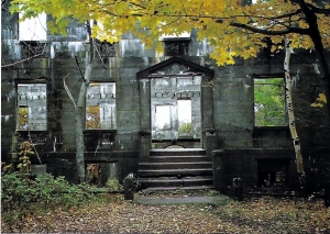
"I will never kick a rock"

Monthly archive

October 2017

The Ravine 10-26-17

in Uncategorized by

The Ravine”

Windows Through Time

Columbia/Greene Media

July 29, 2009

Robert and Johanna Titus


When one of us (Robert) was a boy of about ten, one of his absolutely favorite places to go with his friends was a place simply called “the ravine.” It was a pretty decent canyon cutting through a sequence of Triassic age red sandstones. Boys would hike up and down it, scramble beneath overhanging ledges of rock, and just have a good time. As a grownup geologist his life hasn’t changed much. The one exception being that now he now explores ravines with his writing partner and wife.

To the two of us the word ravine still conjures up images of damp recesses and moss covered rocks, with fern forests, whitewater brooks and plenty of rapids. Ravines are still nice places to go, and hike, and explore.

But, as you can probably guess, there is a lot more. We’d like to take you to a ravine in the Hudson Valley and take a look at it and learn something of its marvelous history. That would be the ravine found along something called Doove Kill. We’d like you to visit it with us, take a good look at it, and then, most importantly, think about what a ravine really is.


To get there we would like you to find your way to the village of Blue Store, along Rte. 9 in Columbia County. From there, take County Rte. 8 east and uphill. Travel just about three miles and watch for Black Bridge Road. Turn left there and you will very quickly encounter a bridge. The bridge passes across D
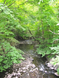
oove Kill, and you can park near it, get out and take a look. Here you can get your first glimpse of the ravine and actually think about ravines in general.

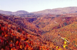
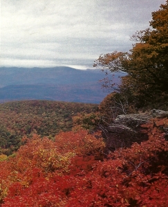
The features that most identify a ravine are the walls of rock that make up their steep slopes. You can see them here. Typically, the creek is forced to pass across ledges of bedrock and they break up its flow and produce whitewater which helps the scenery considerably. Turn around and continue east on Rte. 8 for just about a half mile more. You will soon enter the village of Snyderville and there you will find Taghkanic Road. Turn left onto Taghkanic and watch, again to your left, as you continue down that road; you will soon see more of Doove Kill.

For a short distance the road passes parallel and very close to the Kill. Here it is a very real ravine; it meets all of the criteria. It is deep, steep-sloped, and has plenty of exposed bedrock. There are two small waterfalls here, but unfortunately they are on private property, and we would like it if you did not disturb the residents. But there are places where you can pull over, park, and gaze into the gorge, without bothering anybody. It’s a nice place, except for the poison ivy!

But, we have been promising to do some thinking about what exactly a ravine might be, so we had better get going on that. We can learn more by returning to Rte. 8 and driving farther east, and finding our way into Lake Taghkanic State Park. As you can guess the park is named after the lake that is there. If you drive to the northwestern corner of Lake Taghkanic you will find the source of Doove Kill.

We have to go back into time about 14,000 years. Back then the Lake was a great deal larger than it is today; and a lot deeper. The lake was swollen with the water melting off of retreating glaciers.  Flowing out of that ice age version of the lake was an enormous volume of water. In short Doove Kill had a very different personality back then. It was a raging, foaming, pounding, thundering, whitewater and ice age torrent.

Now you must rethink everything that you have just seen along Doove Kill. In your mind’s eye, we would like you take those stretches of ravine that you just saw on Black Bridge and Taghkanic Roads and fill them, almost to the top, with that powerful whitewater flow. That makes Doove Kill something that you might call a Category Six whitewater stream, or at least is was back at the end of the Ice Age.

Changes your impression of Doove Kill, doesn’t it?

You might even say that it rearranges your whole sense of reality. All of a sudden your image of the Kill has been dramatically altered. It has become a far more exciting place, one with a real ice age heritage.

And that is the whole point. We all started out with an appreciation for the scenic beauty of something that we called “the ravine.” Probably all of us have been to our own ravines and enjoyed the experience immensely. But now we have learned something very different. There is the notion that such a landscape feature has a geological heritage. And it can be a very rewarding experience to come to understand that heritage.


The glaciers of Overlook 10-19-17

in Uncategorized by

The Glaciers of Overlook

The Woodstock Times

Aug 22, 1996

Robert Titus


Mountaintops develop over millions of years and they show all the scars of those great lengths of time. If you know what to look for, you can read a lot of the history that those scars record. Such is certainly the case with Overlook Mountain. The mountain is virtually a history book, recording the events of the great glaciations that once buried the Woodstock area in thousands of feet of ice.

Overlook has long been a popular goal for day hikers. The final stretch of trail leads to the old fire tower at the mountain’s summit. As you round the last turn and approach the tower you will find considerable bedrock at your feet and that is where the story begins. Bedrock is common on the mountain but here it is different; it has a polished look. Also there are long straight gouges, called glacial striations, on its surface. These are the unmistakable signs of the great ice sheet that once covered Overlook.


Glaciers move slowly, but they do move. A great thick glacier, as it passes across a knob of rock, will act like a sheet of sandpaper; it will grind the rock down. The bottom of the glacier is dirty with sand, gravel, cobbles and boulders. The sand causes the polishing. The last few cobbles to be dragged across the rock leave the striations. Hence, the features at the top of Overlook.

The fire tower site thus conjures up quite an image. This location is more than 3,100 feet above sea level and more than 2,500 feet above the floor of the Hudson Valley. The glacier must have been a half mile thick  . . . or more. This is known to science as the Woodfordian advance of the Wisconsin glaciation of about 23,000 years ago. With the possible exception of Slide Mountain, it seems likely that all the Catskill Mountains were covered by the Wisconsin ice sheet. The Catskills then resembled Antarctica or Greenland of today.

We can read the nature of the ice’s movement. There is a compass direction to the striations, a little west of south. The ice sheet must have been relatively thin at first. It seems to have been channeled southward down the Hudson Valley. Then, as it thickened, it swelled up out of the valley and flowed southwest across Overlook Mountain.

The fire tower site is only the first stop in an exploration of the Overlook glaciation. From the fire tower, head east to the ledge which looms over the Hudson Valley with Lewis Hollow immediately below. The site was a popular one during the hotel days. The drop-off is an impressive one and this is a fine example of sheer cliff. The cliff faces a little west of south. And so it is oriented with flow of the ice. That betrays its glacial origins.

The cliff is an example of what is called “glacial plucking.” Ice tends to stick to rock, and so as the ice passed across the south end of the Mountain, this adherence caused it to yank or pluck loose large mases of rock. After enough of this plucking a cliff developed.

You will find the occasional boulder on top of Overlook; I found an especially large one right on the brink of the cliff. These are called glacial erratics. They had been plucked off somewhere to the north and dragged south to this site. They were left behind when the ice melted. Once there were probably a lot more erratics near the edge of the cliff. Alf Evers, in his history of the Catskills, records that all the smaller ones were, long ago, pushed over the edge. The sport was called “boulder rolling.”

Still, there are a lot of erratics on Overlook – away from the cliff. Take the trail back down the hill. To the right, just past the ruins of the old Overlook Mountain House Hotel, is another plucked ledge. Below it the woods are littered with an abundance of erratics. There is no cliff here to push them over.

Before leaving Overlook it is worth returning to the ledge. Gaze out into the valley and with your mind’s eye you can visualize the time when it was filled with a stream of ice flowing south. The ice gleamed white with an abundance of dark blue curved crevasses. Its tide slowly rose up the valley walls and eventually overtopped the mountain. All the Catskills were soon a vast Arctic wasteland. It’s quite a scene to imagine, a scene now only recorded in the rooks.

Contact the author at titusr@hartwick.edu.

Poet’s Ledge 10-13-17

in Uncategorized by

A hike to Poet’s Ledge

Windows Through Time

Oct. 4, 2012

Robert Titus


I wonder how many of you understand just how philosophical we geologists can be. We tend to find ourselves drawn to some fine geological location; then we come to a pause in our rambles, and we drift, insensibly, into deep trance-like thoughts, usually involving thoughts of the immensity of time.

Well, it happens to me – all the time. One of my favorite locations for rambling into the past is a trek to “Poet’s Ledge” in Kaaterskill Clove. If that sounds like a nice place to hike to, then you are right. It’s a gorgeous ledge of sandstone, perched near the top of the eastern end of the clove. It has a spectacular view of this spectacular chasm. You gaze west and you take it in – in its entirety. It can become a profoundly philosophical experience, an almost dangerous one.

From up there, the clove is almost unblemished. You can see the highway that ascends it, but very little of anything else “civilized.” It’s almost pure raw wilderness from up there. We geologists gaze into the clove and see it as it developed, probably over the past 120,000 years. Much of the clove was eroded towards the end of the Wisconsin phase of the Ice Age. That was a time, between 10,000 and 18,000 years ago when the glaciers that had over-ridden the Catskills were in full retreat. They were melting away and enormous cascades of water must have been coming down the canyon of Kaaterskill Clove.

When I find myself at the top of Poet’s Ledge, it is impossible for me not to ponder such moments. I look up the clove and I see glaciers in the highlands. In my mind’s eye it is always an overcast day. The weather is unusually warm for the Ice Age, but this is the end of that time and warm is okay. The glaciers up there are gray on this cloudy day. They are totally disintegrating in the warmth. I always pick the day when the melting is at its all-time peak. Actually I pick the very hour when the flow hits its maximum. When I am in a mind’s eye mood I can do this sort of thing.

I look up the clove at that great high-elevation ice once again. Then I notice that, exactly where Haines Falls is today, there is a break in the ice. A roof has caved in right there, and I can see an enormous current of water. It is an absolutely enormous fire hose of ice water. The flow comes from a hidden sub-glacial Kaaterskill Creek. It reached where the falls are today and then momentum carries it forward so that it could bore its way through the ice and create a great cavity. I gaze at the flow of water passing through that cavity.

Below, there is, once again, a roof of ice. Much of Kaaterskill Clove is still filled with ice. The creek is confined to a tunnel passing down the canyon beneath that ice. It is a very erosive flow of water and much of what we know as the clove today is being carved down there.

Across the clove is another flow of water. It pours off the mountaintop, just west of Indian Head. The water, up there, is visible, but it quickly disappears into another hole in the ice. There are two sub-glacial torrents in Kaaterskill Clove and now, for the first time, I notice – and appreciate – and understand the terrible muffled roar that I hear.

The two sub-glacial flows form a confluence immediately below, almost a thousand feet down. All downstream from here the roof of ice has entirely caved in. The torrent of water continues rushing down the lower canyon. Right now the “Red Chasm” of Kaaterskill Clove is being given birth to by these powerful, raging, foaming, pounding, thundering, whitewater torrents. From here echo’s a thundering roar; nothing is muffled about this sound. It deafens the ears.

This panorama from Poet’s Ledge is a horrifying scene of nature’s rawest power. The sights, the sounds, and the pounding vibrations all combine to make a jarringly terrifying scene. The pounding meltwaters are cascading, crashing, coming down the canyon with the power of a small asteroid. Never before has there been so much power here; never again will there be this much.

And then it all ends; I am not alone; I am with a group of hikers. We have been sitting on the ledge, having lunch. They are talking and laughing; I have drifted away. Reach the author at titusr@hartwick.edu


A night on Overlook Mountain 10-5-17

in Uncategorized by

A Night on Overlook Mountain

Robert Titus

Kaatskiill Life, 1994

THE ROAD to Overlook Mountain used to be important. It served two main functions: It brought resort tourists up to the mountain’s hotels. Several were built there in succession; they all burned. Also it brought downhill lumbering wagons loaded with Catskill bluestone from the area quarries. Today the road is no longer important. It can’t even be called a road anymore; it is just a hiking trail.

The trip to the top of Overlook is well worth the effort as the peak offers one of the best views in all of the Catskills. To visit this mountain in the early fall, just as the leaves are turning, and to spend the night there under a rising full moon is one of the great experiences of our Catskills. The climb up the path is a bit tedious, however. The trail has none of the interesting steep, rocky stretches that you usually encounter on Catskill trails, just a steady, grinding incline. You know that the long climb is nearly over when you reach the old walls of the last of the Overlook Mountain House hotels. The ruin is a gem. Four stories tall and composed of poured cement, it has the look of something that will be there for an eternity. It won’t.

Beyond the hotel is the mountaintop itself and a state fire tower with its panoramic view. The peak is windswept, and large knobs of rock poke through the thin soils. The strata speak to the geologist and tell of the ancient Acadian Mountains which once lay to the east, but are now nearly entirely eroded away. The rocks we see here were once coarse sands, sediment which accumulated on the slopes of those long ago mountains. These are not sediments anymore; time has hardened them into rock.

Sunset is subtle: The afternoon light dims imperceptibly and then the sky darkens rapidly. This location has been here for four and one half billion years and the site has witnessed all of the sunsets that such a length of time brings. To the east, exactly as the sun descends, a full moon rises; it is the fabled, harvest moon. The first lights to join the moon are the brightest stars; they are soon joined by the lesser lights of the full moon’s sky.

I will have no fire at this night’s camp. I would enjoy the heat, as it is no longer warm out. I wish instead to be alone in time here and I do not want any bright lights to distract me from participating in this particular cycle of time.

Off to the east are the Berkshire Mountains. These beautiful and serene hills are the remnants of the much older Acadian Mountains which once towered over this horizon. It grows fully dark now and the Berkshire landscapes stand in sharp contrast under the rising moonlight. As the moon continues its ascent, it draws away from the mountains and they fade into the darkness. With an evening mist, the lights of civilization in the valley below also disappear.

The Berkshires were not always here, but it has now been four hundred million years that the moon has been rising above their silhouettes. Before then the view was not that of New England but of an ancient ocean, the Iapetus Sea, unblemished by any land masses, let alone mountains. Back then it must have seemed as if that sea’s stretch extended forever into the east. But that was false and there were clues of something going on out there beyond the eastern horizon. From time to time, dark clouds of smoke rose above the horizon. First they were only low, dim and distant, but later they appeared larger and darker than ever before. There had to have been a day, a moment in time, when a single pinnacle of land first emerged upon that horizon. During the lifetime of any Devonian age creature, no change would have been noticed, but as many lifetimes passed, that pinnacle was transformed from an occasional glimpse to a permanent fixture upon the seascape, growing larger and broader. Occasionally great, thunderous roars would emanate from that eastern monolith and sometimes even lightning could be seen within the billowing black masses of soot. It was the nighttime and moonlit eruptions which were the most spectacular. The immense, rising clouds of dense smoke, sharply outlined in moonlight, would have been unforgettable – had anyone been there to remember.

In between these more and more frequent volcanic episodes, the peaks of the now great mountain range became white with snow. Even here in the tropics they had grown tall enough. Beneath the snowy fringe, the mountains were a desolate brown and lifeless gray. But as they loomed taller and closer, a thin low red horizon competed with those elevated but more somber colors. Then finally, joining the red, was a very low wisp of green.

The Overlook Mountain vicinity had once gazed out upon the unbroken blue of the Iapetus Sea, but now it would witness the disappearance of that sea. The red and green horizon grew closer and the image sharpened into that of a low tropical foliage growing upon the brick red soils of a coastal delta. These were the world’s most primitive forests, dominated by twins of the great tree ferns. Crawling the soils were the first land animals, primitive insects, millipedes and spiders. These were the pioneers of forest ecology, and forest ecology is the chief claim to fame of the great Catskill Delta.

The delta advanced slowly, but it could not be stopped; time cannot be stopped. The waters went from salt to fresh; they suddenly grew murky and brown, and the Overlook vicinity was buried. The shrouds of burial were the sediments of the rivers, lakes and swamps of the great delta. These soft, warm sediments encased and preserved much of the delta forests.

Millions of years, then tens of millions of years of blackness followed. The pressure of the thickening sediment intensified. The great delta became a petrifaction, its soft warm sediments hardened into cold stone sculptures of rivers, lakes, marshes and forests. After about one hundred and fifty million years of increasing pressure, the weight of the overburden stopped growing. And, after a long pause, the pressure, ever so slowly, began to lessen.

If it was possible for light to penetrate rock, even a little, then, over the next 200 million years the Overlook vicinity would have become dimly and then brightly illuminated. But this does not happen; light does not pass through rock and Overlook lay, for all of this time, in complete blackness.

The sleep of Overlook was dreamless and darker than anything humans can know. It was deepest and coldest just before the dawn. Above there were thick and heavy glaciers grinding their way southward. The full moon, now low in the western sky, brightly illuminated a plain of arctic desolation, extending in all directions as far as could be seen. Only in the west were there peaks that rose above this crystalline sea. These appeared as silhouettes of black against the radiant moonlit horizon.

The processes of weathering and erosion do their work slowly but they never quit. Glaciers do speed up the process and the inevitable results are sudden: the breakthrough occurred and sunlight, for the first time in 400 million years, warmed the strata of Overlook.

*      *      *

Just exactly as the harvest moon sinks beneath the horizon, the new day’s sun breaks above the cloud banks of the Hudson below. This view, a Frederic Church masterpiece, has returned once again as it has for millions of years, and as it will for millions more.

I sleepily watch the sunrise above the low fogs of the Hudson Valley. Beyond there is neither an Iapetus Sea nor an Acadian Mountain Range to be seen, only the low blue hills of the Taconics. I am stiff and cold and in need of coffee. That can be found in the lowlands below, where I will soon return.

Time, the English geologist James Hutton observed, gives us no vestige of a beginning, no prospect of an end.


Go to Top