"I will never kick a rock"

Monthly archive

July 2017

Visions of an ice age past 3 – Catskill Creek

in Uncategorized by

Visions of an Art Trail past – Catskill Creek

On The Rocks

Woodstock Times

Jan. 31, 2013

Robert and Johanna Titus


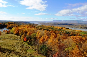
We have been traveling the Hudson River Art Trail, seeing the landscapes that so inspired the great American artists of the 19th Century. But ours have not been the journeys of art historians, but those of geologists. We are privileged to see what the artists could not; we can look into the distant past. Last time we visited Frederic Church’s Persian Revival house Olana and we saw the ice age history of that site. In this journey we visit what may have been Thomas Cole’s favorite scene: that is the view of Catskill Creek from Jefferson Heights just west of the Village of Catskill.

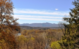
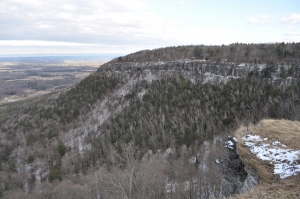
That location was just across Catskill Creek from Cole’s home. He frequently hiked there and composed views. In the foreground there was a great bend in the creek as it flowed by below. That was scenic enough, but in the distance it all got better. Out there was the Catskill Front, the fabled Wall of Manitou, lying on the western horizon. In a recess on that distant horizon, but still close enough to be seen, were the lower stretches of Kaaterskill Clove.

Cole seems to have done a dozen or so paintings at this location. Like any good artist he experimented. He tried out the scene at different times of the day and during different seasons of the year. His art can be called luminism; he liked to place the sun in the far distance and paint its light shining down and across the landscape. He could vary the sun’s color with the time of the day, saving deep reds and oranges for late afternoon. He returned to the site as the years went by, and painted changes that had occurred there. Much to his dismay he saw a railroad line put in. He lamented the encroachment of industry on what had been a purely pastoral image.  Landscape artists do not celebrate industrial development.

As the generations have passed since Cole’s time, a different sort of development came along: the forests returned. At least the trees did. They grew up and blocked Cole’s cherished view. When we first searched for it, we could not find it; it was hidden by the foliage. When the Art Trail was developed that posed a problem. The trail guide leads visitors to a nearby restaurant site, but you just cannot obtain a good view there. Thomas Cole’s grand scene seemed to have been lost to the very Nature he painted so well.

But, very recently, that all changed. At the top of the hill, at Jefferson Heights, a new sidewalk was installed. You can walk it and look to the west and, especially during the winter, you can see Cole’s bend in the river, right in front of you, and in the distance, the Catskills are out there too. It’s not as clear a view as Cole had, but it’s pretty good. We were thrilled when we first found this. We were sharing a moment with Thomas Cole and the whole Hudson River School of Art.

But we also saw this view as Cole couldn’t; we saw it about 15,000 years ago, at the close of the Ice Age. As geologists we get to pick exactly what times we go back to and visit. With our mind’s eyes we can witness those moments. And, for this journey, we picked a very good moment to visit. We wanted to see the Cole view as it was when the ice was melting. But we also wanted to see that view on the day when the melting reached its all-time peak. There had to have been a day and an hour when a warming climate was melting an absolute maximum of ice. That was the very moment when more water was cascading down Catskill and Kaaterskill Creeks than ever had before or ever would again. The channels and valleys of these streams strained to contain the flow – and failed.

We stood upon the same Jefferson Heights site, but for us it was that exact moment, 15,000 years ago. Below us, a vastness of water was pouring down the creek. It ignored the bend in the river as its flow rose and swelled up to overwhelm the whole valley. What we saw was a horizontal waterfall. The water presented a mixed image, contrasting its own gray brown colors with whitecap whites. This torrent swirled, and foamed, and thundered as it rushed by. The power of the flow was frightening; the sound was deafening. This was the full fury of Nature, displayed in a riotous image.

We looked up, all the way beyond to distant Kaaterskill Creek. Even in our mind’s eyes we could not travel that far. It must have been much worse out there, with a still greater flow of water coming down that steep canyon. We strained to see and were frustrated that we could not. We debated it and finally convinced ourselves that we were seeing a large rainbow rising above the mouth of the Clove. It was too distant for us to be sure. We were awed by all that we beheld and we fully understood that we were seeing history in the making. What we were watching was nothing less than the great rising crescendo of an ending Ice Age.

Nobody ever painted this scene.

Contact the authors at randjtitus@prodigy.net Join their facebook page The Catskill Geologist


Visions of the Past 2 – Olana

in Geology by

Visions of the Past – Olana

On The Rocks

The Woodstock Times

Robert and Johanna Titus

Jan. 13, 2013


We have been, in this column, following the new Hudson Valley Art Trail and highlighting some of the great landscape art that was done in our region. Our focus, however, is to see how this landscape was influenced by the Ice Age. Our thesis is that it was the glaciers that sculpted these landscapes long before they were ever painted. We are scientists who have a deep appreciation for the broad and gradational boundaries where science blends into art. Stay with us on this theme as we write this series. Today let’s go to Olana, Frederic Church’s Persian Revival mansion high atop a hill overlooking a sweeping vista of the Hudson Valley. It’s stop number two on the Art Trail.

Church was, arguably, the most successful of all the Hudson Valley artists. His career began when he was a student of Thomas Cole. It was Cole who guided the young Church in developing his skills and he certainly influenced Church into becoming the great landscape artist that history remembers. One of those influential moments occurred when Cole and Church climbed what would come to be called “Church Hill,” east of what is today the Rip Van Winkle Bridge. Church must have been most impressed with the view; you look south and see, before you, the Hudson River and much of the Hudson Valley. In the distance was an unsurpassed vista of the Catskill Front and beyond the Shawangunks. The view is a natural kaleidoscope; it is never exactly the same from one moment to the next. As the sun and clouds pass across the sky, the light and shadows change continuously. The experience is compelling; your gaze is irresistibly drawn towards the valley view and you drift into an almost hypnotic state.

   View from Olana

   Frederic Church would someday own that view. He would build his palace, Olana, there. It would become a work of landscape art. His south porch would face that hypnotic view and it still does. Church, during the last third of his life, developed a number of locations on his property as “planned views.” These were sites where the trees were cleared and view opened up, purely for the art of it. Since his time, those clearings slowly became overgrown with trees and shrubs, blocking those magnificent views. But in recent years some of them have been restored. The 200 or so acres that are Olana will again be the work of art that Church intended all along.


Church Hill is the product of the Ice Age – entirely.

Church hill, when seen from high above, is a beautifully sculpted, symmetrical, teardrop shaped hill. It almost seems unnatural; surely some manmade process shaped it. But it is quite natural; it is an ice age feature called a rock drumlin. Starting more than 20,000 years ago, the Hudson Valley glacier began overriding this sizable knob of bedrock. That rock is part of the Normanskill Formation, and it is largely dark sandstone and black shale. By rock standards, that is actually pretty soft stuff, so it was not surprising that the passing ice might begin to cut into it.

Satellite image of Mt. Moreno and Church Hill


For 10,000 years or so that advance of the ice continued, on and off, during several major chapters of glaciation. Each advance of the ice brought a new episode of erosion into the bedrock. And each episode improved the shaping of the hill. Most drumlins are not composed of bedrock; they are made mostly of sand, gravel, and cobbles. This material comes to be shaped into a very predictable form. We liken that to the shape of an upside down teaspoon bowl. These typical drumlins are stretched out, north to south. The north-facing slopes are the steepest; the south facing ones taper down at a more gentle angle. The left and right flanks of drumlins are symmetrical, with steep slopes and a sharp crest in between. Rock drumlins are the same, just composed of shaped bedrock, not gravel.

Olana was placed at the top of the spoon bowl, at the crest of the drumlin. Its south porch faces the south, tapered slope and that afforded it its spectacular view. Two of the other planned views that you can visit today are on the Ridge Road. They are perched on the flanks of the rock drumlin. One looks west across the Rip Van Winkle Bridge, while the other looks northeast. More will be developed with time.

Frederic Church certainly appreciated his landscapes, but did he understand the ice age nature of this all? That is not entirely clear.  Church was fascinated by the polar landscapes of today’s world. He painted them in some of his most memorable works. See his Aurora Borealis (1865) or The icebergs (1861.) Church did know something about geology and he lived in a time when geologists had learned a great deal about our ice age history. But how much did Church understand about the ice age history of Olana? We really don’t know. His library contains several geology books but they do not offer inscriptions that might help us fathom his thinking on this matter.

We hope he did; we would like it if he could have seen Olana as we do. When we stand on the south porch at Olana we are, like anyone else, captivated by the view. We sit and watch as it changes before us, and it is a wonder. We are envious of Church’s 30 years living here and his experiencing all this for all that time. But we probably see the view differently from how he did. In our mind’s eyes we travel to this site when it was at the bottom of a moving glacier. The cold is unbearable, but worse is the absence of sunlight. At the bottom of the thick ice all is in pitch black darkness. But although we cannot see, we can hear the sounds above as the glacier moves, making low groans and sudden sharp cracks. But below and all around we hear grinding noises. Cobbles and boulders are being dragged across the bedrock.

Nobody painted this scene.

Contact the authors at randjtitus@prodigy.net Join their facebook page The Catskill Geologist.


A vision into the past 1 – Cedar Grove

in Uncategorized by

Visions of the past 1, the Porch at Cedar Grove

On The Rocks

The Woodstock Times

Dec. 2012

Robert and Johanna Titus


One of the cultural landmarks of our region is the renowned Hudson Valley School of Art. Its artists explored the Hudson Valley and the eastern Catskills during the middle two quarters of the 19th Century. The canvases they painted captured the region when much of it was still wilderness. The word “sublime” has been used to describe the raw natural scenery that they sought to portray.  We admire the works of these artistic genius’ and we revere the landscapes that, to a great extent, have still not yet lost their wild natural states.

The recently conceived of Hudson Valley Art Trail is at once an honor to this artistic tradition and also an opportunity, even inducement to go out and explore the natural beauty that inspired the art. The two of us have been closely involved with Cedar Grove, the Thomas Cole National Historic Site, pretty much since it was founded, a bit more than ten years ago. It is only natural for us to participate in the art trail, bringing our own visions to it. We pause at the various locations on the trail and gaze at the scenery that was painted at each one.

But we bring very different visions to each site. We are scientists and we see each one for its geological heritage. We look into the past and see a certain sublimity that was denied to most of these artists. We feel privileged to see what they could not, and we have strived to portray what we see in some of the Art Trail literature. We are not artists; we serve as geologists who “paint” with words our visions of the past. We would like to, starting here, bring you back to many of the sites on the Art Trail and transport you visually to our version of these landscapes.

The view from the porch at Cedar Grove. Catskills in distance.


We begin where the Art Trail begins, on the porch of Cedar Grove, Thomas Cole’s home in the village of Catskill. The porch faces west and commands a view of the Hudson Valley and the distant east-facing slopes of the Catskill Mountains. Today’s view is noisy with highway sounds, and urban in its modern setting, but it is still a very fine experience. Thomas Cole enjoyed a far more rural version; he would likely have been appalled by what is here today.

But we can do Thomas Cole one better. He was last here in 1848; we can travel back to 15,848 BP and enjoy the very same view at a very different time. Back then the Cole porch site did exist; one could have found it using GPS devices. We don’t need that technology; we have the benefits of something far better – the mind’s eye.  We travel back to an August 9th of that year and stand exactly where the Cole porch is and gaze west.

What happens immediately is that all the traffic noises go silent. It is a quiet day, with no wind. There are a few late summer insects but no birds. All around us is a thin foliage of young pine and spruce. None rise high enough to block our view to the west. Out there, across the valley, lie the Catskill Mountains. We see shapes that are familiar. We spy Windham High Peak and Cairo Round Top. To the south lie Stoppel Point, then North and South Mountains. We strain to see High Point and Round Top and the distant Overlook Mountain. All these form a familiar skyline, but still – something is wrong with our view.

Below these peaks there is no greenery. The slopes of our Catskills lack trees. This landscape is just starting to recover from the Ice Age. Forests, and even lone trees, have not yet had time to repopulate our Catskills. This is such an uncomfortably austere view of the Catskills; we can scarcely believe it. But it is so.

Now we look down a little. The whole of the Hudson Valley in front of us is flooded. Stretching out across the valley for nearly ten miles is a grand glacial lake. It has a name; it is Glacial Lake Albany. We cannot see that far, but it extends off to the south, all the way to today’s New York City. Most of the way, it is about 60 feet deep, so it is a large lake. Cold too; it all formed from recently melted ice.

Maybe we cannot see to its southern end, but just to the right of our view is its current northern boundary. The waters of Lake Albany abut the edge of a valley glacier which is spread out across the entire expanse of the Hudson, west to east. This is the Hudson Valley glacier and, on this summer day, it is melting and in full retreat. Though warm, it’s a gray day. The glacier is in various shades of gray, broken by large black fissures. Enormous volumes of meltwater are pouring off of, and out of the glacier.

Suddenly we see the breaking off of a great chunk of ice. The disintegrating ice has become fragmented and unstable. A huge ice berg has broken loose and plummeted into the lake below. That berg sinks quickly into the waters and then, in a flash, rockets up again. Now it has fragmented into a hundred smaller bits. This miniature cataclysm had set loose a new natural disaster. The great splash has generated a tidal wave that is billowing off to the south. A chaos of foaming water, bobbing up and down with a host of small bergs, is expanding off to the south. The tumult rocks back in forth in the confines of Lake Albany, but in an hour or so, all settles down again.

None of this will ever be painted.


The escarpment at Thacher Park July 6, 2017

in Uncategorized by

The escarpment

Windows Through Time

Columbia-Greene Media.

May 2010

Robert Titus


You have probably seen the news of a woman who was struck by a falling rock at John Boyd Thacher Park. I hope she has a speedy recovery. But, what drew her to the trail where this accident occurred?

John Boyd Thacher Park is one of our region’s scenic gems. It occupies a position high up at the top of the Helderberg Mountains. The whole park is one great overlook. The view is a sweeping panorama of a broad rural landscape. There are apple orchards down there and all sorts of beautiful countryside. Fifteen miles, or so, off to the northeast lies Albany, the nearest urban area. You can see it quite well, without it messing up the scenic nature of what is close by.

The park has been there for very nearly a century. It was the gift of Mrs. Emma Thacher, wife of an Albany mayor. It, of course, is named for her husband. It has always been a state park and a popular one. The view is its leading draw. You can see much of the Hudson Valley from up there, as well as parts of the Mohawk Valley. There have been a number of facilities, including a swimming pool, play areas, picnic and barbeque facilities. These are joined by 25 miles of trails, the best known one is the Indian Ladder Trail which drops down off the escarpment and follows a tall cliff off to the west. The trail passes waterfalls and the openings of caves. It’s not a hard hike, having well laid out staircases and footings. The park is well suited for nearly everybody in the family.

The Helderberg Mountains form what is called an escarpment.  That is a great ledge of rock facing a broad open landscape.  You are aware of this wherever you are in the park. All the roads and sidewalks follow the edge of the escarpment and all of them offer views.

What, exactly, is an escarpment? It’s not just a ledge of rock; it is a ledge of very hard rock. Something about it makes it far more resistant than horizons of strata above and below. In this case, those strata belong to the Helderberg Limestone. You will see the Helderberg as soon as you arrive. The rocks have a dull gray color to them. I hate to admit it, but these are really boring looking rocks. In this column, we have visited the Helderberg a number of times. It is one of the most important units of rock in our region. At Thacher we find out how important.

In short, it produces a lot of important landscape. I would like you to keep in mind this concept of an escarpment as you travel to Albany and back. Coming south from Albany on any number of highways you will look ahead and up and see the breath of the Helderberg Escarpment. It spreads across the entire horizon when viewed from most locations. That makes it big and Thacher occupies just a very small part of it.

Some highways, like Rt. 32, will take you right up the steep slope of the escarpment and, after you have crossed the top, you will soon find your way to another escarpment. This one is smaller but it is there. And, after passing that one, soon you will find your way to still another. It doesn’t seem to ever end. With time, you will look ahead and see the northeast Catskills. These mountains make up one more escarpment. And it is for the same reason; the northeastern Catskills are composed of stratified rocks almost as tough and resistant as the Helderberg Limestone.

We are learning something about stratigraphy itself. Our region is composed of layers of rock, strata, which all tilt just a little to the southwest. Some horizons are composed of tough stuff and they have eroded into escarpments. Other horizons are composed of strata that are much softer and they become lowlands or swales, lying between the escarpments. Once we understand this and we travel around and notice it all, then we have a better sense of the lay of the land. We become much more knowledgeable and attuned to the landscape all around us.

Then there is time, the endless amounts of geological time that all this represents. We drive south on Rt. 32, from Albany to the Catskills. We pass one escarpment after another, one horizon of stratified sedimentary rock after another. And it slowly sinks in how much time it must have taken to accumulate all these horizons of rock. It is reckoned by geologists that we are looking at tens of millions of years.

The season is up and running at Thacher. May 1st was the usual opening day for the Indian Ladder Trail. That will give you a chance to go visit this fine escarpment. Contact the author at titusr@hartwick.edu Visit his website “The Catskill Geologist.”


Go to Top