"I will never kick a rock"

Monthly archive

October 2016

Those old bluestone sidewalks 10-27-16

in Uncategorized by

Those bluestone sidewalks

Windows Through Time

Robert Titus

July 2nd, 2009


We rarely pay sufficient attention to the very greatest emblems of our history, in time to save them from destruction. The old covered bridges were replaced by modern spans and, not until only a few were left, did anyone bother to care. By then it was nearly too late, but a few were saved and are still to be seen. All across the land, beautiful old barns have been left to decay and fall down. Today you can actually see signs along the highways, posted by people who wish to buy old barns and tear them down to salvage and sell their wood. It’s such a shame. I fear that nobody will do anything until just a handful of barns are left.

There’s another emblem of the past that I seem to find myself alone in worrying about. That is the bluestone sidewalk. We see them all over the place, but they are being replaced by cement and that has been the case for a long time. Many are still there, but for how long?

15-1-flow-lineati-3

Old bluestone sidewalk

If you care to take notice, they can be seen. There are several of them in my town of Freehold. I still see some in Oneonta where I teach. The city of Hudson has some and so on. They are old; they were installed a long time ago, and they are showing their age.

But just what is bluestone? That, of course, is something any local geologist will know about, and I am no exception. Bluestone is a type of sandstone and thus (guess what?) it is composed of sand. It is quartz sand as a matter of fact. So, where did all that sand come from?

Much of Catskill sandstone was originally formed as sediment in the channels of ancient rivers. There were a lot of rivers around here during the Devonian time period and so there is a lot of sandstone. When it has just the right amount of the mineral called feldspar in it, then the sandstone takes on a vaguely blue appearance and, presto, it is bluestone.

Those Devonian age rivers sometimes had powerful flows of water within them. These currents swept along large masses of sand. We are probably talking about Devonian age flood events. At the peak of a flood, the currents were powerful and dirty with sand and silt. But floods don’t last forever; they do abate. As the currents, once again, slowed down, they could no longer continue to transport their load of sand. Most of it had to be deposited. At exactly the right current speed, sand is deposited in thin, very flat sheets. These strata are the ancestors of sidewalks.

The horizontally laminated rock that results is well-suited for splitting. Long ago quarrymen learned how to do this, and they became very skilled at splitting and cutting the rock into slabs just the right size to make sidewalks. It was backbreaking work; I hate to think how hard it must have been. But, the pay was pretty good by the standards of the 19th Century, and so many were attracted to the work. Good bluestone quarries sprang up in the Hudson Valley, west of the river. Then more were opened up in the eastern Catskills. You can still see the old, now abandoned quarries; they are common

15-2-bluestone-quarry

View of an old bluestone quarry

The earliest quarries eventually played out and were abandoned. The industry has slowly migrated westward across the Catskills, and now it’s centered in the vicinity of the Delaware River. People still produce very good bluestone out there.

The rock is found all over the world, but the best bluestone comes from the Catskills. Our stone is enormously resistant to weathering, and that is why it made such good sidewalks. The rock doesn’t become very slippery when wet and that helps too. Blocks of it, cut a century ago, have had people walking across them for all that time and they often show little wear from all the abuse. But, they are getting old. It’s the corners that go first. Weathering works in from both sides of a corner and gradually decomposes it. Then, commonly, stresses build up within the stone, resulting in its cracking. That hurries things along quite a bit.

So, sadly, town fathers look at their old sidewalks, and decide they have to go. They come to be replaced, usually by cheaper cement. There is probably little that can be done to stop or even slow this, but it is sad. Still, we should appreciate this fine old stone, and we owe it to ourselves to be a little more aware of these sidewalks when we see them. They are part of our heritage and a very important part of it. You can tell your grandchildren about them. And tell me too, if there are good bluestone sidewalks near you. Contact the author at titusr@hartwick.edu

Joints and the origin of the Wall of Manitou 10-20-16

in Uncategorized by

Joints on the Wall of Manitou

Windows Through Time

Robert and Johanna Titus


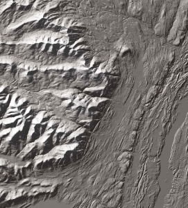
Three weeks ago this blog was about the Wall of Manitou. We wrote about its origins but, ever so coyly; we were not very specific in this. The wall is ten miles long, straight as an arrow and that arrow has a compass direction of south-30 degrees west.

14-wall-of

                                                                                Satellite image of the Wall of Manitou.

And two week ago our blog described long straight fracture patterns called joints. They are very frequent throughout the Catskills and, remarkably, most of the time, they also have compass directions of south–30 degrees west. This was a hint, a big one. Did you pick up on that? There is a story here. Those joint fractures and the Wall of Manitou have too much in common for it to be an accident. There must be some sort of a relationship. Well, there is.

We hope you remember that joints form when great masses of rock are compressed, usually during great mountain building events. The compression does not actually fracture the rock, that happens later in time, when the stress ends and the rocks “relax.” Our Catskills joints compressed sometime after 400 million years ago. Something you would likely call Europe had collided with North America and that collision resulted in the rising of mountain ranges throughout all of New England. Geologists call them the Acadian Mountains. If you keep reading this blog you will hear a lot more about these mountains. Anyway, that massive collision compressed rocks throughout New York State, especially the Catskills

14-2-catskill-delta

The collision of “Europe” with North America and the resulting Acadian Mountains. See NE/SW orientation.


A long time after the uplift of these mountains, Europe broke free from North America and drifted back off to the east, leaving a growing Atlantic Ocean behind. That split was about 200 million years ago. And that was when all the relaxation occurred and that is also when all those joint fractures came into existence. Joints always form perpendicular to the maximum relaxation stresses. These maximum stresses, as it happened, were northwest to southeast. So the joints formed northeast to southwest, just what we see (We are ignoring secondary joints at a 90 degree angle to the primary ones).

Did you follow all that? Europe collided with North America, compressed North American rocks and, when Europe drifted away to the southeast, all those joints formed. Well, what does any of this have to do with the Wall of Manitou?

It has, in fact, everything to do with it. Perhaps you might like to hike the Blue Trail, north from North Lake. Along the way, here and there, you will find northeast/southwest trending joints. There are a lot of them.


????????????????????????????????????

Hikers stand upon Blue Trail joints.

   It must have been just like that during the Ice Age. During parts of the Ice Age the Hudson Valley was filled with ice, right to the top. And that ice was moving. It formed a great stream of ice, ever so slowly flowing down the valley, and of course, rubbing up against the Catskill Front.

Here’s where it gets interesting. Ice, when in tight contact with bedrock, forms a bond with the rock. In simple terms, the ice sticks to the rock. Did you ever stick your tongue to the bottom of an ice tray when you were a kid? Well, then you know exactly how sticky ice can be. That happened to bedrock along the Wall of Manitou, during much of the Ice Age.

Well, when enough of a tug was generated, the moving ice would, from time to time, yank huge masses of rock loose. And – you guessed it – those joint fractures proved to be weak points where the breaks could most easily occur. Had you been to North Lake way back then, you would have heard, sporadically, great echoing cracking sounds. Each would mark the breaking of a mass of rock off of the growing Wall of Manitou. Almost always, those fractures had a northeast to southwest orientation.

Over long periods of time – and this is geology; we always have long periods of time – the Wall of Manitou came to be shaped and steepened into what it is today. All the action was occurring out of sight, beneath the surface of the Hudson Valley glacier. Today, the great Wall rises about 2000 feet above the floor of the valley.  And it does something that most slopes don’t do. It steepens toward the top. That’s one good reason why it is such a scenic feature.

When we stand at the edge of the Catskill Mountain House ledge, we always look out at the valley before us and we always see it filled to the top by a glacier. The ice slowly moves by us, headed south. And every so often, we do hear those ear splitting cracks, generated by masses of rock breaking free and being dragged off by the advancing glacier. Then our mind’s eyes watch as the ice begins to melt away. The ice shrinks away from the ledge and reveals nature’s ice age handiwork. That Wall of Manitou rises out of the melting glacier. It is a marvelous revelation.

Contact the authors at randjtitus@prodigy.net. Join their facebook page “The Catskill Geologist.”

A Petrified Delta 10-13-16

in Uncategorized by

A Petrified Delta

Windows Through Time

Robert Titus

June 26th 2009


The Catskills present a number of public images. To many they are the land of Rip Van Winkle. We, in the Catskills, love the old story and retell it often. The plot seems to have been set right here on the Catskill Front. Other people immediately conjure up images of Borsch Belt hotels with their stand up comics. Then there are the images that were painted by the artists of the Hudson River School of Art. It really was here, in our Catskills, that a deep, artistic appreciation of a “sublime” landscape was born. We are all enriched by that view. Closely related to this is the great outdoors image of the Catskills, something that appeals to nearly everybody. Much of the spiritual side of what we call environmentalism comes from places like our Catskills.

But to geologists there is an altogether different concept of the Catskills. Not better, not worse, but very, very different! You see, there are thousands of feet of sedimentary rocks that make up the Catskill Mountains. It is mostly sandstone, along with a fair amount of shale. Throughout this vast thickness we find sedimentary features that we can identify. These reveal ancient environments petrified in the strata. They are fragments of ancient landscapes that have hardened into rock. We see original deposits with their original structures, and we can put names on them.

There are for example, throughout the Catskills, cross sections of ancient river channels. There are the deposits of old floodplains. We find ancient ponds and swamps. And so on. And when I say ancient I am not kidding around. These rocks range from more than 400 million years in age to about 350. That places them all in a time period that we call the Devonian.


                  14-1-platte-falls


       Outlines of cross sections of Devonian stream channels at Plattekill Falls.


All of these petrified Devonian environments are typical of a great river delta. And again, I am not kidding around. These delta deposits are thousands of feet thick and stretch from the Catskill Front, in the Hudson Valley, to at least western New York State and probably a lot farther. That’s big!

All this has a name; it is called the Catskill Delta. Some would call it the Catskill delta complex. The latter emphasize that these delta deposits stretch for hundreds of miles south through the whole Appalachian realm. They have a point. This is not just a single delta, but a long complex of many deltas.

How did they form? Well, one thing is certain: every delta consists of heaps of sediment that were deposited when a river, big or small, flowed into a standing body of water, again big or small. Really big deltas form at the ends of really big rivers. The Mississippi River has a large delta. The Nile Delta is at the end of an equally long and large river.

But, you might ask “There are two problems: where did the really big rivers go? And, by the way, where is the body of water that it flowed into?” Those are good questions and they deserve, actually they demand answers.

Where did the rivers go? Well, that gets us to all that sediment. Big deltas need big sources for all their sand, silt and clay. The Mississippi has most of North America; the Nile has much of Africa. But back in the Devonian, North America was not very big and it could not provide much sediment. Instead our river, or rivers, flowed down the slopes of a great range of mountains, lying in today’s New England. These, called the Acadian Mountains, had, in fact, many streams flowing down their western slopes. All of them carried sediment out onto the great Catskill Delta. Those mountains eroded away long ago and their rivers are gone too.


14-2-catskill-delta

         Map of Acadian Mountains with delta rivers flowing off to the north.


.    But what about that standing body of water? Where is that? The rivers of the Catskill Delta flowed across it and then entered something called the “Catskill Sea.” This is where it all gets very surprising. The Catskill Sea was a shallow ocean that stretched clear across all of North America. Beyond North America it merged with something that we would probably want to call the Devonian Pacific Ocean. In short, North America was a breathtakingly different place back in the Devonian.

All this gets us back to my original point. When a geologist has a good view of the Catskills, say from across the Hudson River, then what he or she looks at is a scenic range of mountains. What we actually see, however, is very different. We look up at the Catskills and see a petrified delta. If we could, we would treat it like


14-3-petrified-delta

Petrified delta, viewed from Greene County. Rte. 81.


so many other specimens we find in the field. We would chisel it loose and bring it back to a museum. We would find a cabinet with a drawer labeled “fossil deltas.” We would put it in that drawer and keep it.

But it is too big for that. Better to enjoy it as it is!

Contact the author at titusr@hartwick.edu

Joints below the Bridge 10-6-16

in Uncategorized by

Fractures from the distant past.

Windows Through Time

Robert Titus


a-13-joints


Joints just below the Bridge

There is a fine outcropping of Devonian age sandstone all along Catskill Creek, both upstream and downstream from the bridge. That, by itself, would make a good story but there is something else. I noticed some prominent, long straight fractures in the rock. These fractures would, of course, take me through another window of time. These are just below the downstream side of the bridge.

Not all rock fractures are as straight and parallel as these, so I became curious. I climbed down to the outcrop and took a measurement of their compass directions (a well-armed geologist always has a compass handy). I was not the least bit surprised with the results. As I expected, I found a bearing of south, 30 degrees west, a nice almost northeast to southwest orientation. That, I knew, is very common pattern to see throughout all of the Hudson Valley and Catskills. It’s what we found in last week’s blog. I had better do some explaining.

There are fractures and then there are fractures. Most are irregular; the rocks break up into more-or-less random and erratic patterns. But, as I had noticed, the ones at the Durham Bridge were altogether different. They were, all three of them, straight as arrows and perfectly parallel to each other. There was a very clear pattern here.

When Nature puts a pattern in front of a scientist she is challenging him to figure it out. Patterns need to be explained. And the best explanations, when we come up with them, are called theories. Geologists, very long ago, came up with good theory to explain what I was seeing beneath the Durham Bridge. These special fractures are called joints. Joints are just what we have seen here; they are straight, parallel fractures of the rock. But how did they form? That’s the theory part.

Joints record chapters in the tectonic history of a region. They began to form when the rocks, long ago, came to be compressed. It may be hard to imagine that rocks can be squeezed, but they can. That requires immense pressures, but such pressures do occur within the Earth’s crust – deep within the crust.

Now the funny thing about all this is that rocks do not fracture when they are compressed; they have enough give to absorb that stress. But compression does not last forever; it eventually does end, rocks expand, and that is when the fracturing begins. There is a sort of relaxation which occurs as the pressure comes off. At that moment we find that rocks are brittle and it is exactly then that they crack to form joints. So, what triggered all this? We need more theory.

Cycles of compression and relaxation, strong enough to deform and then fracture rocks, can only be associated with the truly great tectonic events. These are not just run of the mill earthquakes; these are the towering mountain building events. And the one which triggered our Catskill Creek joints was one of the biggest mountain building events ever; it made the northern Appalachians. These joints record the collision of something you might call Europe with North America.

That resulted in early uplift in the Northern Appalachians of New England. Compression occurred when the collision occurred. Much later in time, Europe split from North America and drifted away. That’s when the relaxation occurred and then the joints formed.

So my bike ride across the Durham Bridge turned into quite the journey into the past. I gazed at those joints and recognized that they were taking back into time. I was looking at fractures that dated hundreds of millions of years into the past. Now I gazed upwards towards the eastern horizon. In my mind’s eye I saw very tall mountains on that horizon. They were white with snow at their peaks. They have a name; they are called the Acadian Mountains. These had started forming nearly 400 million years ago and had largely eroded away by about 300 million years ago. Those joint fractures that had caught my attention have been here for much of that time.

There is nothing unique about the joints at the Durham Bridge. It is quite likely that there are many similar joints near where you live. These are features that people tend not to notice until they develop trained eyes. Well, you have just trained your eyes! Please look carefully at rock outcroppings in your neck of the woods. Look for long straight fractures, often with smooth flat surfaces. These are the joints in your neighborhood. Reach the author at titusr@hartwick.edu


Go to Top