The Columbia County Catskills
Stories in Stone
Columbia County Independent
Updated by Robert and Johanna Titus
Feb. 18, 2005
Columbia County is certainly a nice enough area, but few of you probably would
guess that anything here is really nationally known. Nevertheless, in geology circles, there is one nearby spot that is truly famous. This location is known as the Becraft Hills or, to many geologists, Becraft Mountain. You would be amazed to discover how many geological maps of this site are found in college level geology lab manuals. Every semester thousands of geology students do exercises involving the geology of the Becraft Hills.
And they have been doing them for generations; there is some classical geology here. You can join in; travel south on Rte. 9 from Hudson and look way up above. You will see some stratified rocks, limestones, high up there. You may not be able to tell it, but these strata are inclined to the east.
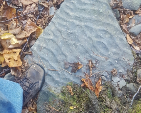
Continue south and turn east (left) onto Rte. 23. At the intersection of Routes 9 and 23 you are at the southwestern corner of the Becraft Hills. Before you will be an outcropping of gray limestone. That’s typical of the hills and it is part of what makes them remarkable. These limestones are an isolated bit of the Catskills. The limestones, called the Rondout and Manlius Formations, make up the very base of the Catskill sequence west of the Hudson River. They are the very foundations of those Catskills. As we said there is the whole lower Catskill sequence here. The Becraft Hills have several units of black shales as well.
And this stratigraphy speaks to geologists; it tells us that once, long ago, the stratified rocks of the Catskill sequence extended eastward, across the Hudson, and blanketed much or all of Columbia County. How could that be?
The structure tells all; we already saw that the strata on the west side of the Becraft Hills mostly are inclined to the east. Continue east on Rte. 23 and turn left on Fingar Road; make another left on Hiscox Road, and one more left onto Rte. 29 (aka Spook Rock Road). Now to your left (west) you will see some fine strata of limestone. All these beds are dipping to the west. In short, the western strata dip east and the eastern strata dip west (do you follow that?). That gives the Becraft Hills a bowl like structure, something that geologists call a syncline.
That takes us back to a time called the Devonian, a little less than 400 million years ago, when the mountains of western New England were being formed. The mountain building event was called the Acadian Orogeny and it involved a lot of uplifting of all the area’s bedrock (after all you have to have uplift to form mountains).
You also get a great deal of folding of the strata and that is how we formed the Becraft sequence. We should say protected the Becraft sequence. Mountain building uplift should have elevated the Becraft Hills and subjected them to processes of erosion that, in the end, would have destroyed them. Instead the Becraft strata were folded downward into the bottom of that syncline bowl where they were protected from erosion. All across the rest of Columbia County the Catskill sequence eroded away, but not here.
. Geologists sometimes call such an erosional remnant an outlier and, by itself this would make it worth the visit of a geology class, but there is more. The Becraft Hills, it seems, are also shot through with faults. You have heard of the infamous San Andreas Fault and you know how earthquake-prone all of California is. Well, back during the Devonian time period, those nearly 400 million years ago, Columbia County was something of a California-like earthquake zone. Those ancient faults, now long inactive, can be seen and mapped by geologists.
All this is something that geology teachers cannot resist. Every year scores of geology field trips visit the area. Watch, come next spring, for the large vans with school names on their sides. Look for a dozen or so scruffy college age kids happily climbing about on the rocks. These are field trips and they are a real institution among geology departments.
And they have been for a long time. The first geologists started studying here in the 1820’s. A century or so ago the area became a popular location for summer field geology courses. Back then, before cars were available, the relatively large number of geological features in a small area made this a very practical place to teach and learn geology. We wish we could see some of those old horse and buggy field classes. Generations of young geology students cut their teeth on the rocks here. Later, when transport had improved considerably, it became preferred to travel to the American West to do full-fledged field camps.
some geology and a very large number of young geologists still come here. Take the tour yourself.
=======================================================
Contact the authors at randjtitus@prodigy.net. Join their facebook page “The Catskill Geologist.”