"I will never kick a rock"

Monthly archive

June 2025

Yellow Alert – June 16, 2025

in Uncategorized by


Yellow Alert?

Robert and Johanna Titus

The Columbia County Independent; May 5, 2005


We have, recently, had a growing sense that something has been going on geologically, here in our upper Hudson Valley. We think a pattern has been developing. Scientists notice patterns and we seek to understand them. We had better explain.

We commonly drive past the Gilboa Reservoir. Lately, the water has been pouring over the top of the dam. That’s unusual; most of the time the reservoir is well below the dam’s top, sometimes the reservoir is nearly empty. It’s easy to say that it has just rained a lot recently, but we wonder.

Over the last few years there have been a number of damaging earth slides in the upper Hudson Valley. First came the Delmar slump, south of Albany, which put a major road out of commission for quite some time. It had been built on the muddy sediments of an old ice age lake, Glacial Lake Albany. The sediments simply gave way and slid into Normans Kill. Well, these things happen, or so I thought at the time.

But then, last year there was another slump, this one in Schenectady. The edge of an old Lake Albany delta slid downhill and that doomed six homes. Soon we had a small slide just a mile from the Titus family home in Freehold. Again, this spring, we have seen still another nearby bank give way and now it seems to be oozing water. That’s getting too close for comfort.

Slumps are an ongoing problem in the Hudson Valley, and we have written about them before, but there seem to be a lot of them lately. Two weeks ago, there was a new slump in Amsterdam. This one also seems to have involved the sediments of another ice age lake delta. That’s alarming; why are these events coming at such a rapid rate?

But then it got even worse. We began receiving E-mails from people in Valatie, complaining about flooding basements. Three houses on New Street have been experiencing serious problems for weeks. Basements flood; that’s their job, but some of these folks claim that they have never seen the likes of this even after decades of residence and they are worried.

All this may just be coincidence and might mean next to nothing. Or all this may just indicate that we have had a lot of rain lately. That would explain this year’s problems, but it would not tie in the events of recent years.

In the end, it seemed to me that there was enough to warrant a little investigation. It looks to me, on the face of it, that the region’s water tables have been rising and that the recent heavy rains have triggered a series of problems. This trend may be something that has been developing over the last several decades. Can I document this the way a scientist should, and can that lead to an explanation? Well, I can try.

We checked with the National Oceanic and Atmospheric Administration website and found some interesting things. New Yorkers have seen some climate change over the past century. Our average temperature has climbed only about one degree Fahrenheit. More interestingly, however, our rainfall has climbed about six inches, from 36 to 42 inches/year, that’s 16 percent.

If we have seen a lot more rainfall, then it follows that there should be more groundwater and higher water tables. Add a few heavy rains and it seems logical that basements would start to flood, and slumps might be triggered. People might well remember that these things didn’t happen in the distant past because they really couldn’t have.

What we are suggesting is that if we have a wet summer or, worse, a snowy winter and rainy spring next year then we may see serious problems. Is all this good science? Certainly not, it is the result of just a little work over a short period of time in response to some rapidly occurring events. But this something we should be watching.

A Journey Through Time at Kaaterskill love 6-9-25

in Uncategorized by

A Journey through time in Kaaterskill Clove

The Catskill Geologists – The Mountain Eagle; 11-3-2017

Robert and Johanna Titus


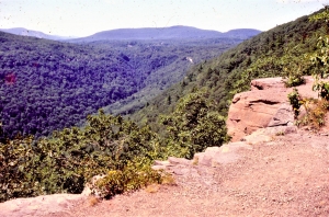
Have you ever hiked the north rim trail at Kaaterskill Clove? It’s one of those many great experiences that anyone living in the Catskills should have done – perhaps, like us, many times. Better still, it’s something you should take visitors to see. When we go there, we stop at Inspiration Point and look down about a thousand feet or so, and gaze into the distant past. Way down there, about 15,000 years ago, was a raging, foaming, pounding, thundering, whitewater torrent. Those were the waters of the melting glaciers of those late ice age times. That flow did most of the work of carving Kaaterskill Clove. That’s what makes this truly a geological wonder.

But there is still an older time, represented down there. Down in the very depths of the canyon, there are stratified sandstones and shales. The canyon is about a thousand feet deep here, so there must be an equal amount of stratified rock. Those rocks are middle and late Devonian age, which makes them about 385 to 375 million years old – that’s in very round numbers. It’s natural for geologists to ponder such vast numbers. We are pros; we are professional scientists, and we are not supposed to wax poetic about such things, but – we can’t help it.

The two of us began to wonder just how many years had passed by from when the oldest strata, at the bottom of the Clove were deposited, to when those at the top came to be. We got out some publications from the New York State Museum and began to make some “guesstimates.” We are only going to make some gross approximations today; so don’t hold us to any of our numbers. We just want to give you a notion of when all the stratigraphy at Kaaterskill Clove came into being, and how long it took to be deposited. If somebody thinks they can come up with better numbers, we welcome them

We think the strata at the bottom of the canyon belong to a unit of rock called the Plattekill Formation. The Plattekill is a unit of gray and brown sandstone. The New York State Museum places the middle Plattekill at about 385 million years in age. We think the top of Kaaterskill Clove corresponds with the top of the Oneonta Formation, a largely red sandstone, and that makes it about 381 million years in age. The math is pretty easy; we get about 4 million years of time represented from the bottom to the top of the clove’s stratigraphy. Remember those 1,000 feet that the canyon encompasses? Well, we divide through and we get about 4,000 years per foot of stratified rock.

Now, none of this is great science, and none of it is great math. A foot of river sandstone might have been deposited in a few hours. A foot of red shale may have taken many, many thousands of years to form. There must have been sediments from vast expanses of time that were eroded away and lost forever. Other great lengths of time just never saw any deposition at all. But, we think we have come up with some reasonable approximations and that is all we are aiming at.

Again, stand atop Inspiration Point and look down those thousand feet. See 4,000 years of time for every foot below you.

Contact the authors at randjtitus@prodigy.net. Join their facebook page “The


The Depths of the Sea

in Uncategorized by

The Depths of the Sea

The Catskill geologists; The Mountain Eagle; Dec. 1,2017

Robert and Johanna Titus


Have you ever been to Manor Kill Falls? You take Rte. 30 to where it intersects Rte. 990-V and then you head north a few miles and then watch for the signs. They have a fine parking lot and then you have a choice of trails. The upper trail heads for the top of the falls, but we want you to take the lower trail. That one takes you down to the bottom of the falls where you get a fine scenic look at it. That’s where the best geology is too.

You stand at a good location and look up at the falls. If you have an eye for rock types then you will recognize a sequence composed mostly of thinly bedded black shales. These strata are interrupted with the occasional dark sandstone. That’s a good start but now you need to get a better look at these rocks. You can do that by looking down; the ground is littered with rocks. A thin “shingle” of black shale will reveal a very fine-grained sedimentary rock; it is composed of silt and clay. None of those grains are large enough to be seen. It is black from all the organic matter in it – the stuff of ancient life.

It is natural for a geologist to begin looking for fossils. Those provide the clues for figuring out exactly what kind of environment is represented here. The hunting was disappointing at first but, after a short while, the fossils of some shellfish were turned up. These were creatures called brachiopods. Like clams, they have two shells, and like clams, they spent all of their lives lying on the seafloor. But, they are not clams; they have a very different anatomy, so different that they are not even distant cousins of clams.

Nevertheless, these brachiopods are marine animals and they tell us that all the strata we are looking at were formed, about 390 million years ago, at the bottom of something that is often called the Catskill Sea. Stand back at look up again. Each horizon of stratified rock once took its turn being the floor of that ocean.

Well, now we know something important; The Manor Kill Falls location was once the bottom of a large ocean. The next question that comes to mind, to a geologist anyway, is “just how deep was this ocean?’ We can’t throw a plumb bob overboard so just how do we determine this important bit of information. The answer is that we don’t, we can’t. But we can make some approximations.

Here’s how we do that? We have already looked those lithologies over and we have found that most of the bedrock here is fine grained black shale. That’s a type of rock that forms in relatively deep waters. The black color speaks to us of a relative scarceness of oxygen on that sea floor. That black biologic material would have decayed away if there had been oxygen. We did not find many fossils so not too many shellfish lived down there.

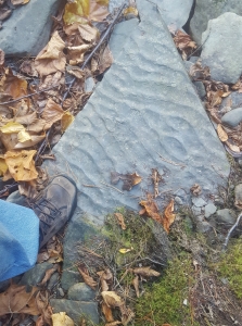
We thought we were building a case for a very deep sea environment, but then we found something else. That something else was downstream a ways. There we saw a slab of rock covered with what are called ripple marks. Take a look at our photo. These are slightly asymmetrical ripples and that indicates that these were sculpted by currents passing across that sea floor. What does that mean? Ripples are rare in very deep waters. It means that this seafloor was not all that deep.

We stood on that slab; we were literally standing on the bottom of an ancient sea. We looked up and, in our mind’s eyes, we could see the dimness of just a little sunlight that had reached down to this seafloor. It just wasn’t that deep.

Contact the authors at randjtitus@prodigy.net. Join their facebook page “The Catskill Geologist.” Read their blogs at “thecatskillgeologist.com.”


Go to Top