The Origin of Flint; Apr. 28, 2025
Our Reader’s Rocks: the Origins of flint.
The Catskill Geologists; the Mountain Eagle, Oct 17, 2017
Robert and Johanna Titus
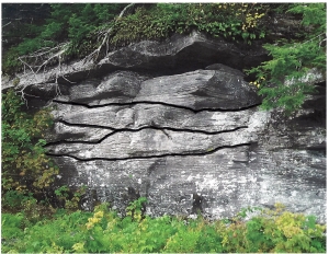
Dear Bob and Johanna: My husband and I were out exploring north of Rte. 145 (near intersection of County Rtes. 443 and 156) in Berne when we found an interesting outcrop. One of the rock strata had peculiar black masses within it. I am sending a photo. Can you tell me what this is? Debra Teator, Freehold.
Thank you Mrs. Teator. You did the right thing sending us a photo. They can be very helpful. We can’t always identify geologic features from a photo, but this time we can. The gray rock surrounding those black masses belongs to something called the Helderberg Limestone. We expect to be writing a lot about the Helderberg as it is a very important local unit of rock. Its most important aspect is that it takes us back about 400 million years to a time when almost all of our region lay beneath the waters of a shallow tropical sea. If we could transport you to that Helderberg Sea, you would look around and swear that you were in the Bahamas.
The Helderberg Limestone is very well exposed at John Boyd Thacher Park, and we did not know of your outcrop in Berne. The Helderberg is composed of several subunits called formations, and this one is the Kalkberg Formation. Its sediments were deposited well offshore, in waters that were certainly not deep but might be best described as subtidal. If you were at the bottom of the Kalkberg Sea during the daytime, then you could look up and probably see a lot of sunlight.
Now, what is chert and how did it form? Chert is described as being microcrystalline quartz. That makes one of nature’s most common types of minerals: quartz. But, unlike normal quartz, its crystals are extremely small. That’s the easy part; what is harder is figuring out exactly how it formed. Late at night, in geology bars, this has always been the subject of debate. We will tell you our best understanding.
The first thing that happened is that the sediment that makes limestone was deposited. This stuff consisted of very small grains of calcium carbonate (CaCO3). Most of those grains had previously been parts of the shells of shellfish. Clams, snails and other shell-bearing organisms had died and their skeletons had broken up into grains of sand, silt and clay.
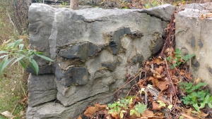
After this sediment had been deposited but before it hardened into rock, it was affected by chemical processes. If we understand it properly, water rich in dissolved silica (SiO2), was being squeezed out of the soft, wet sediments. When the dissolved silica reached layers of sediment that had a low pH, which is also known as a high acidity, then the microcrystalline quartz crystalized as chert. The chert formed into globs which are commonly called chert nodules. If the nodules grew large enough and were abundant, then they would grow into each other and form strata of chert. That is what is seen in the photo.
So, today’s journey into the past has taken us into 400 million year old sediments and allowed us to watch the formation of chert. This material is better known to most people as flint. That’s the stuff that Stone Age cultures learned to fashion into stone tools, such as arrowheads. It also functioned in flintlock rifles.
Contact the authors at randjtitus@prodigy.net. Join their facebook page at “The Catskill Geologist.” Read their blogs at “thecatskillgeologist.com.”
Have you found some geology we might want to write about? Send us a photo.