A visit to the side of a road
The Catskill Geologists; The Mountain Eagle; July 26, 2019
Robert and Johanna Titus
We try hard to get columns out every week here in the Mountain Eagle. The secret is getting good photos to work with. Once we have the right picture, it is usually easy to put together an interesting geological yarn. It’s such a blessing for us that today’s smart phones come equipped with cameras and good ones at that. When we were younger, we could have never dreamed of taking pictures with a telephone, but we depend on that now. Wherever we go, we keep a sharp eye out and whenever we see something good, we just pull out our phone” and shoot. Pretty soon, you are reading about it.
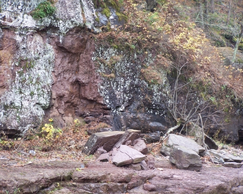
That brings us to today’s yarn. One recent Tuesday evening we were on our way to WIOX in Roxbury when there it was – some fine road work. We love road work; so often it brings to light an exposure of bedrock. Take a look at our photo. It was taken alongside the Susquehanna Turnpike, a few miles west and uphill from the village of Durham. Look again, you might not guess it but there is a lot of geology in there. We geologists always start at the bottom and work our ways up from there. That takes us from the oldest to the youngest – a trip through time.
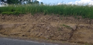
In this photo the oldest strata are of typical Catskills bedrock, a horizon of sandstone. You might prefer to call this rock Catskills bluestone, it doesn’t much matter. In either case, we looked at the rock and were transported about 385 million years into the past. There we found ourselves in the channel of a substantial river. That’s where the sand of this sandstone had been originally deposited. We walked up to the exposure and held our hands out. We could feel the powerful river currents that had once passed by here. Then they slowed down and then they stopped. This stream had jumped its channel; right here it would never flow again. That’s not as unlikely as it sounds. Streams don’t flow on forever in one channel; they do alter their courses and, long ago, that happened right here. Those sands came to be buried under more sediments, then more and then thousands of feet more. They would soon begin a process of compaction that would, with time, turn them from sediments into the bedrock we see here.
What happened to all those other sandstones – the ones that used to lie above? The answer is that they were all eroded away. We looked up into the sky and “saw’ thousands of feet of sedimentary rock rising above us. And we knew that they had, again so long ago, eroded away. And the last of that erosion is represented by the platform about halfway up our photo. That surface is important. Once, out of the north, an erosive glacier had ground its way across it.
Our photo shows that, above that erosion surface, lies a few feet of – what? – soil? Actually no, this is something else. It’s a few feet of earth that is called a ground moraine. A ground moraine is a relatively thin horizon of material that dropped out of a melting glacier at the end of the Ice Age.
We had stopped along the side of the road, attracted by something that looked of interest. We had taken a photo and had found ourselves another good yarn. This yarn involved an ancient river and a passing glacier. Our yarn was spread out across hundreds of millions of years. It is a good yarn.
Contact the authors at randjtitus@prodigy.net. Join their facebook page “The Catskill Geologist.” Read their blogs at “thecatskillgeologist.”