"I will never kick a rock"

Monthly archive

April 2024

An Ice Age Torrent. Apr. 4. 2-24

in Uncategorized by

An ice age torrent – and you can see it

The Catskill Geologists; The Mountain Eagle; June 8, 2018

Robert and Johanna Titus


We have long enjoyed joining in on the hikes sponsored by the Mountain Top Historical Society. This Saturday (2018) there will be one that takes its participants right into the thick of an ice age meltwater torrent. If that sounds like fun then you might consider coming along. The hike will trace the path of what is called the Horse Trail; it can also be called the Harding Road Trail. It ascends from the bottom of Kaaterskill Clove to near the top of South Mountain. It was put together in the 1880’s to bring guests up to the then newly built Hotel Kaaterskill.

The story of the Hotel Kaaterskill is an oft told tale. George Harding had been a long-time guest at the famed Catskill Mountain House, but then there had been an acrimonious argument between him and Mountain House owner Charles Beach. Beach told Harding that if he didn’t like the Mountain House then he should build his own hotel. Harding was a very wealthy man and he did just that; his hotel would be just across South Mountain from the Mountain House. He needed a road to bring guests to his hotel and that was the improbable origin of the Harding Road Trail.

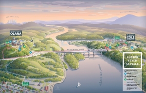
The Harding Road Trail follows a zigzagging path up the south slopes of South Mountain. Take a look at the small, dashed line near the bottom of our map. Our hike will follow the trail and ascend about 1,700 feet before we get to the top. It is billed as a 7.6-mile hike and rated as moderate in difficulty.


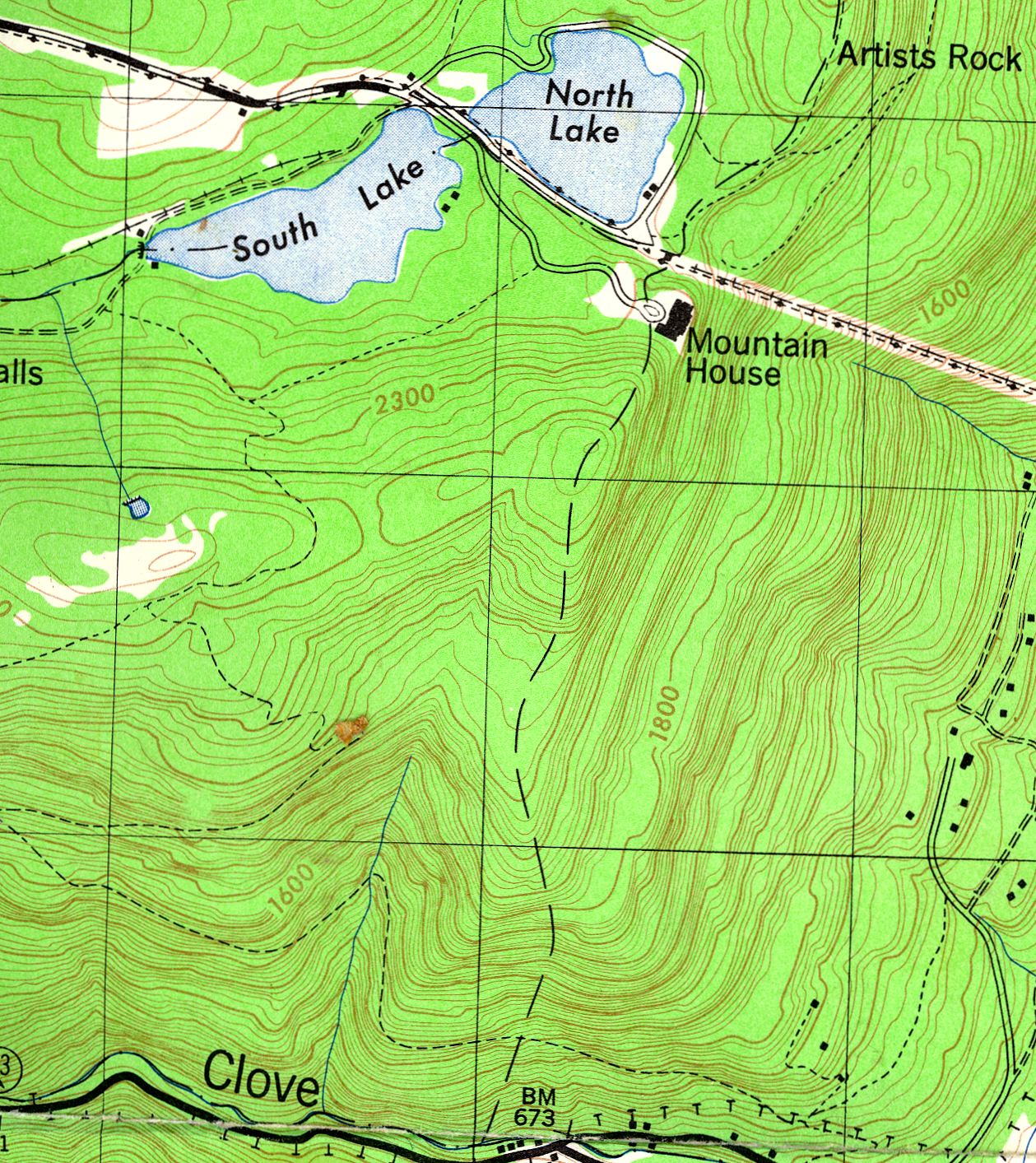
But what about that ice age torrent? Well, that will require a little use of the mind’s eye. Can you read a topographic map? Well, once again take a look at our illustration. Our trek will cross a relatively small canyon at an elevation of about 1,400 feet. It has a small stream in it (see the blue line). If you trace the vee-shaped contour lines then you can follow this canyon all the way up to an elevation of about 2,400 feet. But the canyon is mapped as being dry most of the way to the top. It wasn’t always like that. We did an article in Kaatskill Life many years ago about this canyon. We reckoned that it had been an active and powerful torrent of glacial meltwater toward the end of the Ice Age. We are guessing that all of the Hudson Valley, along with Kaaterskill Clove was, at that time, still filled with ice. We see all of the North Lake vicinity and all of North Point and South Mountain as rising above the ice.

There is a lot to the story that we don’t know. We are guessing that there was some sort of ice dammed lake at the top of South Mountain way back then, a larger version of North and South Lakes. But we have not been able to find much physical evidence for the shores of this lake. That remains a mystery.

Our stream was thus a subglacial one. Water from that lake plunged down a hole in the ice, a glacial feature called a Moulin. It’s quite something to imagine. Raging, foaming, pounding, thundering torrents flowed down the subglacial tunnel. It must have been loud, but its sounds were all but muffled in the complete darkness beneath the ice. And our hike will, spiritually, pass through the flow.

Contact the authors at randjtitus@prodigy.net. Join their facebook page “The Catskill Geologist.” Read their blogs at “thecatskillgeologist.com.”

The Glaciers Got There First – Apr. 18, 2024

in Uncategorized by

The Glaciers got There First

The Catskill Geologists; May 19, 2019

Robert and Johanna Titus


Have you been to the Walkway across the Hudson at Poughkeepsie? It’s a pedestrian bridge that, high up in the sky, crosses the river; We promise you, it’s quite the experience. But, opening next week, (2019) is something just as good and a lot closer. That’s the Hudson River Skywalk. The Skywalk also spans the Hudson, this time across the Rip Van Winkle Bridge. In so doing, it links two important historic sites: Frederic Church’s onetime home, Olana, and Cedar Grove, the Thomas Cole Historic Site. The new trail extends from Cedar Grove, across the bridge. and then it ascends the hill to Olana. Can there be a “theme’ to a walkway? If so, with this one it’s the Hudson River School of Art. Cole and Church were that “School’s” two leading lights.

We said that the Skywalk was just as good as the Walkway, but maybe we can write about something that makes it even better. If you get a chance and you head out over the Hudson, we would like you to look and see how steep the slopes are on either side. We are talking about the slope just beneath the western end of the bridge and the other slope just beneath Olana. That steepness is something that is not always easy to take notice of, but it is important. Shouldn’t there be a floodplain? Rivers are supposed to flow across broad, flat floodplains, aren’t they? So, why not here?

The Skywalk – Picture courtesy of Olana


We got to thinking about that and came up with an answer, a good geological answer. Halfway across the bridge we looked east and west and then north. In our mind’s eyes we saw a glacier. It was perhaps 14,000 years ago and, for the most recent time, an ice age glacier was advancing down the Hudson Valley. That glacier rubbed up against the slopes on both sides of the river. Glaciers can be very erosive and this one was no exception. It cut into Church Hill where Olana is perched. That would greatly improve the view that Frederic Church would eventually paint. It also cut into the western side of the river. All this erosion left no room for any kind of floodplain. Instead, it formed a rather boxy valley with a sizable river flowing down a surprisingly narrow pathway. You probably never noticed this, did you? Well, go out onto the Skyway and take a look.

The official opening is set for June 1st (2019). People will congregate at Olana and at Cedar Grove. Each group will set out on a “parade” to the Skywalk Trail. If all goes well, they will all meet at the middle of the bridge. There will be a ribbon cutting at the park near the bridge’s toll plaza at noon. We don’t think there will be a golden spike, but it should be a fun event.

Contact the authors at randjtitus@prodigy.net. Join their facebook page “The Catskill Geologist.”


Joints along Rte. 145 – Apr. 11, 2024

in Uncategorized by

Joints along Rte. 145

The Catskill Geologists; The Mountain Eagle, May 16, 2019

Robert and Johanna Titus


Science may seem cut and dried to many. We scientists just know everything, don’t we? We look at things and figure them right away. Don’t we? Well – no, and no again. Sometimes we see things that we just can’t figure out. The two of us have been having that sort of a problem lately and it all began along Rte. 145, That’s at the top of the hills you see as you approach Middleburgh from the south. On the right side of the highway is an impressive outcropping of typical Catskill sandstone. Take a look at our photo.

That outcrop makes up a very fine wall of rock. It actually seems too fine. The rock exposes several nearly perfect, smooth and upright surfaces – too smooth and too upright.  What is going on here? Rocks are supposed to break up into jagged rough blocks, aren’t they? It looks like we have some explaining to do.

These surfaces are fractures in the rock that are called geological joints. There is a good bit of scientific theory behind this. Joints record chapters in the tectonic history of a region. They began to form when the rocks, long ago, came to be compressed during a tectonic event. It may be hard to imagine that rocks can be squeezed, but they can. That requires immense pressures, but such pressures do occur within the Earth’s crust – deep within the crust.

Now the funny thing about all this is that rocks do not fracture when they are being compressed; they have enough “give” to absorb that stress. But compression does not last forever; it eventually does end. Rocks then expand and that is when the fracturing begins. There is a sort of relaxation which occurs as the pressure eases. At that moment we find that rocks are brittle, and it is exactly then that they crack to form joints. So, what triggered all this? We need more scientific theory.

Cycles of compression and relaxation, strong enough to deform and fracture rocks, can only be associated with the truly great tectonic events. These are not just run of the mill earthquakes; these are the towering mountain building events. And the one which triggered our Rte. 145 joints was one of the biggest mountain building events ever. That was the collision of Europe with North America, about 400 million years ago; it made the northern Appalachians. Episodes of compression and relaxation, associated with massive uplift of the crust, is what created these joints.

All this is good sound scientific theory, so what’s the problem? Take another good look at our photo. Do you see how it appears that large masses of jointed rock came to be yanked out of the ground and carried off toward we, the photographers. How on earth did that ever happen? Well, that’s our problem. We can tell you how we would like it to have happened. We stand there and imagine a glacier rising up the valley. The west moving ice passes by and forms a bond with the bedrock. Ice does that; stick your tongue to the bottom of an ice tray and you will find out for yourself. Well, as the ice continued up the valley, it did that yanking; blocks of rock were plucked out of the ground and dragged off toward Middleburgh.

At least we would like that to have happened; it would be such a nice vision of ice age history. But just can’t convince ourselves that it happened that way; road building seems very likely to have helped out, and that takes the Ice Age out of the story. So, where does that leave us? Well – with an unsolved mystery. We’ll figure it out someday -and get back to you about it.

Contact the authors at randjtitus@prodigy.net. Join their facebook page “The Catskill Geologist.”

Brachiopods April 4, 2024

in Uncategorized by

Brachiopods

The Catskill Geologists; May 25, 2018

Robert and Johanna Titus


If you do a lot of fossil hunting in the Catskills then you probably already know much about what we will be writing this week. But, even if you do, you may well find our column worth reading. It’s about a group of invertebrate shellfish that lived right here. And we mean right here. Look around you. Where you are now was once the bottom of an ocean called the Catskill Sea. That sea takes us back roughly 400 million years ago to the Devonian time period. Now take a look at our photo; it’s a piece of sandstone. Its flat surface is a petrified bit of that sea floor. And, just as it was hundreds of millions of years ago, it is littered with shellfish, now fossils. They are brachiopods. We see them on this rock – right where they lived and right where they died.

These animals, in life, lived within two shells so you might be tempted to call them clams. The similarity to clams is accidental. Brachiopods are a very different group of animals. Their internal, soft anatomy is entirely different from that of clams. Brachiopods are not even mollusks. We have blown up the image of one of these brachiopods in our second photo. Notice that there is a plane of symmetry running down the center of the shell. With clams there are also planes of symmetry but they are found in between the shells, not down their centers. Using symmetry you can always quickly tell apart clams from brachiopods. All this is important because these two groups are the most common fossils found in the deposits of the Catskill Sea. You need to know the difference. With experience that will soon become second nature.

All but one of these fossils belongs to a form of brachiopods called Mucrospirifer. Mucrospirifer shells are categorized by their heavy ridges and those two – tapering left and right – extensions, sometimes informally called “wings.” Mucrospirifer is a very common brachiopod in our region’s marine sedimentary rocks. It enjoyed great success during the Devonian. There is a second species of brachiopod in the upper right corner of our first photo. It too has a plane of symmetry running down the center of its shell.

There are more things that need to be explained here. First, notice how many Mucrospirifers are seen on this bit of that ancient sea floor. And also notice that they are all just about the same size. We are guessing that this represents something that is common among marine invertebrate animals. Such creatures commonly begin life as single fertilized cells, zygotes that were cast out by their mothers. Alternatively, they may have been early and primitive larva. But in the end it was all the same; these very young invertebrates drifted with seafloor currents until they detected a suitable ecology and, then and there, they settled to the bottom and began their lives. A group of invertebrates of this sort, all the same size, is called a spatfall.

Another thing about these spatfalls is that they seem to us to be commonly found on very dark shales. Geologists generally assume that dark shales represent a quiet sea floor with a low oxygen content. If so, then much of the success of Mucrospirifer came from its ability to survive in a wide variety of environments, places that other animals found inhospitable.

But, in the end, what is important here is for you to learn about a common form of fossil, typical of our Catskills. Don’t your feel just a little smarter now that you have read our column?

Contact the authors at randjtitus@prodigy.net. Join their facebook page “The Catskill Geologist.”

Go to Top