
A very old floodplain; a very new preserve
The Catskill Geologists; The Mountain Eagle, May 3, 2019
Robert and Johanna Titus
We have a new preserve in our region. It is called the Mawignack Preserve and it is located at Jefferson Heights, just west of downtown Catskill. It was officially opened last May (2018), and although we had been meaning to visit it, we had been too busy writing Mountain Eagle columns. When we finally got there a few weeks ago, we set about looking for something new to write about. It didn’t take long.
Actually, when we got to its parking lot and looked at a kiosk’s map of the Preserve, we became pessimistic. The Preserve appeared to be just a routine nature trail circling around a sizable meadow, nice but not promising much geology. We set out anyway. The trail soon took us to a right fork, and we went off in that direction. Soon, we looked to our left and saw a very recognizable feature. Take a look at our photo. Behind those trees you should see what looks like a curving river channel. It seems to meander left and then to the right. But it’s not a meandering river; the channel is empty.
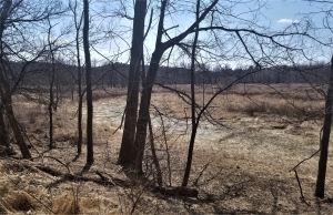
This is, and at the same time, it isn’t a stream meander, what we were looking at is actually called a meander scar. It speaks to us of a river that, long ago, passed by right here, flowing through this now empty channel. We wrote about meanders and meandering stream last week. We found that rivers wind their ways across floodplains. What we didn’t mention is that these meanders don’t last forever. It is typical and normal for rivers to jump their channels and relocate themselves, often during terrible episodes of flooding. Something like that is what happened here, leaving an abandoned meander channel that has been slowly filling up with peat and windblown sediment for centuries – or perhaps millennia.
The Mawignack Preserve lies right next to today’s Catskill Creek and we are guessing that our meander scar represents a very old and very short stretch of that creek as it was in the distant ice age past. But we had another surprise coming. We followed the trail toward Catskill Creek. We now knew that we were walking across the stream meander’s old floodplain. But, when we got to the modern Catskill Creek, we found it to lie about 10 or 12 feet lower than the old floodplain.
How could that be? Geologists may have the answer to that question. They know that, as the glaciers melted at the end of the Ice Age, a lot of weight was melted away too. All that weight flowed as water into the sea. With all that weight gone, the crust actually rose. Our meander’s floodplain rose those 10 to 12 feet above the modern creek.
A story was emerging, and the Mawignack Preserve was getting more and more interesting. We had been transported, as time travelers, back to the very latest chapter of the Ice Age. Before us, an older and more powerful Catskill Creek was flowing by. The region’s glaciers were still melting. We couldn’t feel it, but the ground beneath us was rising. As it rose those 10 to 12 feet, Catskill Creek eroded into the rising ground to form its modern channel. The creek then drained off of the old floodplain and left the meander we had discovered high and dry.
That plain and simple walk on a nature trail had led to our discovery of an intriguing bit of ice age history.
Contact the authors at randjtitus@prodigy.net. Join their facebook page “The Catskill Geologist.”


