"I will never kick a rock"

Monthly archive

January 2026

The Polar Vortex – Jan 31,2026

in Uncategorized by

THE CATSKILL GEOLOGISTS – ROBERT AND JOHANNA TITUS –

The Mountain Eagle; Feb. 26, 2026

THE POLAR VORTEX


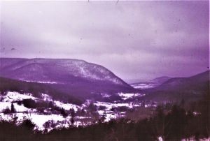
This winter’s (2023) weather news from Texas has been horrendous and we are sure you have heard about it. The temperatures went down to as low as 9 degrees overnight in the Houston area. It snowed, pipes burst, and food and water shortages resulted. The cold has been called historic and it was. We have a child and two grandchildren down there, so this was a real concern.

Why? We think there is something going on that you need to understand. What happened in Texas has occurred up here as well; it’s just that we don’t notice it so much. It all began with global warming and its effect on the jet stream. Decades ago, when global warming was still just hypothesis, that hypothesis predicted that polar regions would warm up a lot more than temperate regions. Northern Alaska would warm up a lot more than New York State. It has. The Arctic has become not nearly so much colder than lower latitudes. Importantly, the temperature boundary between Arctic and temperate climes has blurred.

That led to results that had not been anticipated; the jet stream was affected. We hope you know that the jet stream is a flow of air that undulates up and down as it continuously flows west-to-east. See our diagram. This brings us a lot of our weather, especially winter storms. Historically, the jet stream has been a relatively gentle up and down undulation. See the dotted line on our diagram. That is best developed when the contrast between cold Arctic and warmer temperate warm is sharpest.

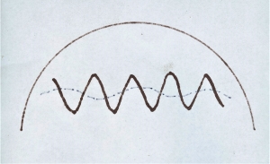
But when the Arctic warms up the jet stream is altered. The up and down undulations become shorter and steeper; they become more pronounced. See the wavy line on our diagram. Their west to east motions also slow down considerably. All this can have a dramatic effect on climate and weather. The down undulations contain the coldest air. When those jet stream undulations spread to the far south, they can bring unusual, even historically cold air into a region where that is not typical. Then because of the slow movement, that cold can stay put on a region for a prolonged period of time. That’s what has been happening to Texas this winter.

Well, these undulations pass through the Catskills too. You will hear each one described as an Arctic vortex. But, up here, we just do not see them as historic events. But this was a very serious event in Texas. We think you should be watching the jet stream diagrams on your local TV forecasts. You may come to better understand what is happening. And that’s, after all, what our column is all about.

Contact the authors at randjtitus@prodigy.net. Join their facebook page “The Catskill Geologist.” Read their blogs at”thecatskillgeologist.com.”

Ice in Grand Gorge.

in Uncategorized by

Our reader’s rocks – Ice in Grand Gorge Gap?

The Catskill Geologists; Robert and Johanna Titus

The Mountain Eagle; Sept.15, 2017


We always give our email address at the bottom of each of our articles. And we can always be approached on our facebook page, so we hear from a lot of our readers. Often they have questions and we are usually able to help them with answers. Every once in a while, we thought we would answer one of these queries in the form of a column so here goes the first.  Recently we heard from a Gerry Hubbard. He sent us a photo of Grand Gorge Gap and wanted to know what the rounded hump on the right is. Take a look at our photo and you can see that hump. We had been wondering the same thing for years and so Gerry’s request got us to do something about the problem.

The first step is to get our topographic maps out and look at them. The Roxbury 7 1/2 minute quadrangle map displayed the Gap. We found that the hump has a name; it is Jump Hill. Then we went back to our photo. The “hump” is actually something that lies in between two valleys. The contour lines on our map indicated a steep but steady slope for each of the two valleys. Each one of those is what geologists call a U-shaped valley. Every trained geologist on the planet Earth quickly recognizes the ice age history of such a valley. They record the passage of glaciers. As ice squeezed through a valley it ground away and eroded the bedrock. The shape that offers the least resistance is the U. Not surprisingly, over a period of time, glaciers will carve those U’s into the bedrock landscape. It gives each of them a path of least resistance. That forms a remarkably picturesque image and that helps make glaciated landscapes so attractive. We geologist are most fond of these U-shaped valleys.

Well, we studied the map and our photo and started speculating about what had happened here, way back, near the end of the Ice Age. Speculation is a word that scientists like to avoid; it sounds so – well speculative. So we use the word hypothesize instead. It sounds better, doesn’t it? We hypothesized the following story: We hypothesize that the larger U-shape, on the left, is the older of the two. We think that a sizable glacier entered Grand Gorge Gap and began eroding the large U-shaped valley. Somewhere along the line, the ice was diverted and a second stream of it passed through what is the smaller, and we think younger, U-shaped on the right. All this erosion left Jump Hill in between.

We hope that Gerry likes our hypothesis. It conjures up quite an image. We travel north on Rte. 30 to where we can park and see this view. In our mind’s eyes we can imagine the advance of these glaciers; we can watch them carve the shapes of Grand Gorge Gap. That view gives us a whole new perspective on this site.

We hope you enjoyed our hypothesis. Perhaps you have a location that we could write about. Let us know.

Death of a Farm; Jan 15, 2026

in Uncategorized by

Death of a Farm?

The Catskill Geologists; The Mountain Eagle; Dec. 6, 2019

Robert and Johanna Titus


Did you read about Hull-O-Farms in the New York Times recently (Nov. 28, 2019)? The article was on the front page, and it was actually above the fold. That’s something that doesn’t happen to a Greene County farm very often. We were intrigued so we read the article with real interest. Turns out there was some geology in the story so here is our version — above the fold in Part D of the Mountain Eagle!

Hull-O-Farms is a 260-acre farm on Cochrane Road in Durham. It has been farmed by seven generations of the Hull family. That makes it one of the oldest one-family farms in America. Sadly, no member of the eighth generation is able to take over from Frank and Sherry Hull. They have had success running it as a farm-stay bed and breakfast, but they are just getting too old for all the hard-work and they may well have to sell their land for development. There is just a little hope; efforts are underway trying to find young would-be farmers and match them with threatened but available farmlands. But it is doubtful that this will happen. It’s a sad story being repeated all across the country. Family farms are disappearing every day and that was the whole point of the Times story.

But we wondered if there was a geological story behind the story, so we did a little research. The was a brief mention in the Times article that the soils were more than just a bit muddy. We started there. We got out our Greene County soil survey and looked up that stretch of land on its map. We found that most the Hull farmland is blanketed in soils called the Burdett silt loam. And, indeed, they are clay-rich and damp., and they are good for pasturing dairy cattle but the economics of that have become weak. They can be farmed but they are only rated as “moderately suited” for cultivated crops. We wondered why and read on. It turns out that the Burdett soils have been developed upon what is called glacial till. Till is a vaguely defined word in the lexicons of geology but it is, in this case, a thin layer of earths left behind by the melting of a dirty sheet of ice. We called a similar nearby deposit a ground moraine in our July 26, 2029  column.

Well. this till/ground moraine was developed upon some Devonian aged bedrock which was essentially a shale. So now we had some more researching to do. We got out our copy of the New York State Museum’ geologic map. It looks like Hull-O-Farms lies upon some marine shales called the Manorkill Formation. These shales were deposited as mud on the bottom of the Devonian Catskill Sea about 380 million years ago. Now they are turning back into muds, the muds of the Burdett soils.

So, to sum it all up. The Devonian seas, that were once here, deposited those marine shales. Those rocks sat there for about 380 million years until the Ice Age when glaciers came along. The glaciers gouged out the shales and turned them into the tills that made ground moraines. During the 14,000 years that have passed by since the Ice Age those glacial deposits have been turned into the Burdett soils. The Hulls came along in the late 1700’s and began the farm. Seven generations later that is coming to an end. There is so much history here; the New York Times story missed nearly all of it.

Learn more about Hull-O-Farms at www.hull-o.com.

Remembering Dr. Don Fisher

in Uncategorized by

Don Fisher of Kinderhook

Windows Through Time; The register Star; Jan 1, 2013

Robert Titus

If you ever visited Don Fisher’s OK Rock Shop in Kinderhook then you saw a wondrous and very crowded display of rocks and minerals mixed with fossils, in a medium-sized store, right on Main Street. You didn’t just have to look at all those specimens; you could touch them, buy them and even take them home with you! Some people open bed and breakfasts when they retire. Dr. Don Fisher opened up his rock shop. It was perfect for a man who had spent decades doing professional geological research, and who wanted to continue his science at a more casual level during his many retirement years. But, more than that, it largely stemmed from the pleasure he took in talking to people about his science of geology. He had the common touch when he was being approached by non-professionals.  The rock shop was the perfect venue for that.

Don had a very long stint at the New York State Museum: 29 years in full. There he was the sixth New York State Paleontologist. That is a very venerable and honorable position. The people who have held that post have distinguished themselves greatly. Don continued this scientific lineage ably, distinguishing himself in the process. He was important.

I first met Don, I think it was in 1972, when I was a member of a team working on the paleontology of the Black River Valley. I was finishing up my doctoral dissertation at the time. Don, and his close friend Larry Rickard, invited us to the Museum to present our findings. That wasn’t enough for them; they wanted to have us lead a field trip to where we were doing our work. We were all eager to do so. Don and Larry were very highly respected geologists, both being, back then, in the primes of their careers. It was a real thrill for me to rub shoulders with the two of them. I quickly found them to be most remarkably likeable people as well as world class scientists.

It is hard for me to cite Don’s most important contribution; there were so many to pick among. The one that I use almost every day is the New York State geological map, published in 1972. It’s actually five maps which together display the distribution of all of the major geological units in New York State. It is an indispensable starting place for any professional work in our state.

But it is important to note that Don always found the time to write for the general public. Some of his best works were found in The Conservationist magazine. These include an article about collecting Devonian fish in New York State. Another was about collecting fossils in general. Still another one was about the Triassic age dinosaur Coelophysis. That dinosaur had left a lot of footprints in southern New York State. That last article he saved for a New York State Museum publication.

But Don’s masterpiece was his “The Rise and Fall of the Taconic Mountains” (Black Dome Press, 2006), written along with Steve Nightingale. It chronicles the geologic history of the Taconic region from way back more than a billion years ago to as late as the Ice Age. I always keep a copy nearby when I am working.  So do a lot of other people. Johanna and I were out exploring in northern Columbia County once and we stopped at a fine outcrop that Don had described in his book. We were looking up at the rocks and down at his book and then back up again. Soon another car pulled up and parked. A man got out and he was carrying his copy of Don’s book. Then, astonishingly, just minutes later, still another car pulled up and another man got out with his copy of Don’s book. There we all were: one outcrop, three cars and three copies of Don’s book! Johanna and I can only hope to have that sort of influence with our writings.

I may be a professional, but I often needed help and advice. I had a number of occasions to call or visit Don and ask him questions when I was developing columns about the geology of Columbia County.” Where can I go see the Stockbridge formation?” “Where can I see a good exposure of a thrust fault?”  He always had the time; he was always very helpful and never had to look things up. He just knew the answers right off the top of his head. And he could give directions too. He had a true encyclopedic knowledge of Taconic geology. The man was a real resource.

We lost Don Fisher on the day before Christmas.  We will miss him greatly.


Go to Top