"I will never kick a rock"

Monthly archive

May 2025

The Art Trail – Part Five – Kaaterskill Falls -May 20, 2025

in Uncategorized by

Hudson River Art Trail: Site Five, Kaaterskill Falls

Windows Through Time; The Daily Mail; Mar. 5, 2015

Robert and Johanna Titus


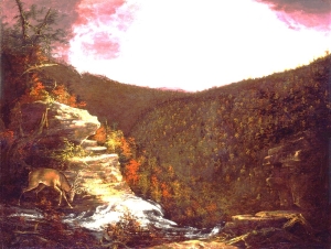
There are many locations along the Hudson Valley Art Trail but one is almost sacred. It is the top of Kaaterskill Falls. The site has been visited for more than two centuries. We have found one inscription carved into the rock there, which dates back to 1810. But the most historic day was likely in the autumn of 1825 when young Thomas Cole first came to visit this site. He was a budding artist, looking to find his way, to establish himself as a painter of landscapes.   Cole must have been most impressed; he painted the view here. See our illustration. It and a few more he did in the area were the making of him – and the making of the Hudson River School of Art.

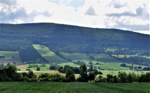
You can see the very same view. From Rte. 23A, take County. Rte. 18 east until you turn right onto Laurel House Road. Park at the end of the road and then walk down the dirt trail another quarter mile to the top of the falls. Walk out only as far as is prudent and look down the canyon below. It is a narrow defile, cut by erosion, mostly during the last few tens of thousands of years. You can stand exactly where Cole stood when he sketched the site.  As we said, it is a sacred location.

We don’t know how many times we have been there. We are drawn to this place. We imagine that all of the artists of the Hudson River School came here as well. Climb up on the great boulder that is perched at the edge of the falls and if you look around, you will find the name Sanford Robinson Gifford cut into the rock. Gifford is one of our favorite Hudson River artists; we were thrilled to see his name here.

All of those artists saw the falls as they are today; the view has not changed. They were most often called to this spot in the autumn when the colors are so good. They must, all of them, have been very pleased to see and then paint what they saw.

But we are different, we are geologists who are drawn to all the same locations with a strong need to see them not as they are, but as they were: specifically, as they were during the Ice Age. Our thesis, in this series, has been that the Hudson River artists painted landscapes that were sculpted by ice age processes. When we go to see these sites, we travel with the mind’s eye to see them as they were. But the mind’s eye must rely on the evidence that feeds it images from the glacial past.  We have gathered that information the hard way, on foot.

Now we have learned enough to return to the top of the ice age falls and see it as it was. We stand at the precise same spot where Thomas Cole too would someday stand. Before us are all the hills that rise above the canyon and the more distant clove. But this is the Ice Age, and all of those hill slopes are bare. Not a single tree is to be seen. We hear sharp cracking sounds, along with loud pops and prolonged groans. We look down. There, below us, is a glacier, a stream of ice. We can’t see it move, but it is a very active lobe of ice. It is being pushed from behind. Farther down below, it is being shoved by more ice, ice ascending from Kaaterskill Clove. Behind that even more ice, a lot more ice, is pushing the clove’s frozen stream. That is the ice of the south moving Hudson Valley glacier.

On this sullen and overcast day the colors are muted, but the image is spectacular. An enormous complex of icy streams is flooding all the valleys around here and sculpting, gouging, and carving a landscape that painters will someday turn into great art.

Contact the authors at randjtitus@prodigy.net. Join their facebook page “The Catskill Geologist.”


A Pretty View 5-5-2025

in Uncategorized by

An image of the past – the Schoharie Creek Valley

The Catskills Geologists; The Mountain Eagle

Robert and Johanna Titus; Nov. 10, 2017


We love to drive around in the Catskills. There is always so much scenery to see. Even at 55 miles per hour you can look and see so much, at least the passenger half of our marriage can. But sometimes – no frequently – we feel the need to stop and get out so that we can stand along the side of the road and just gaze – into the past. Let’s do that in this week’s column.

Our journey will take us to the Schoharie Valley, midway between Middleburgh and Schoharie itself. There we find a special sort of imagery. Take a look at our photo. We are looking east from Rte. 30. In the distance is a hill with the unlikely name of “Rundy Cup Mountain.” In the middle foreground is the valley floor of Schoharie Creek. It’s pretty, don’t you think? That valley floor is remarkably flat and that is important, but first let’s concern ourselves with Rundy Cup Mountain. We want you to look again and notice something you might have missed the first time.

There are sharp boundaries between agricultural fields and forests on the slopes of Rundy Cup Mountain. And those sharp boundaries define a nice curvature to the lower slopes of the mountain. There is not a trained geologist in the whole world who would not immediately see what we saw. We looked, and then turned around and looked west; we saw the same curvature on that side of the valley. That curvature defines what we call a U-shaped valley.

And that is the dead giveaway to the valley’s long ago history. A U-shaped valley, like this one, is always the product of a valley glacier. We looked again and, in our mind’s eyes, we gazed into the past and saw the Schoharie Creek Valley filled, almost to the top, with a glacier. Our mind’s eyes rose up into the sky and we looked down on it. We had returned to an episode of time, late in the Ice Age. We looked south, and we saw that glacier, confined by the valley walls, and moving like a river of ice, south through the valley. The white surface of the ice was fractured by great, dark, curved crevasses. These curvatures betrayed a southward motion to the ice.

We, the mind’s eyes, paused a full thousand feet above the ice. It was a warm day, by ice age standards. Meltwater, in abundance, had accumulated beneath the ice, and it was lubricating that southward motion. We hung in the air and listened; we heard creaks, and groans emanating from the moving ice below us. From time to time, great, explosive, cracking, echoing sounds followed. On this day the brittle ice was advancing at the unheard of pace of 100 feet per day!

It had been a clear ice age mid-June morning, but now it was late afternoon. The sun shined down directly on the ice and a thick ground fog had formed. The fog rose up and enveloped us; we could no longer see the glacier. When the fog finally cleared, it was very late in the day, but it was a very different day. We, the mind’s eyes, had traveled centuries through time – the mind’s eyes can do that. We had arrived at a time, long after that valley glacier had melted away. Now, the entire bottom of the Schoharie Creek was filled with a sizable meltwater lake. Its waters stretched out as far as we could see to the north and to the south. Beneath those waters, sediments of silt and clay were accumulating.

Now we were able to put together the whole story of this part of the valley. Those curved valley slopes had been sculpted by the passing ice; the flat valley floor was younger; it dated back to the level bottom of that post glacial lake.

Contact the authors at randjtitus@prodigy.com. Join their facebook page “The Catskill Geologist.” Read their blogs at “thecatskillgeologist.”


Go to Top