"I will never kick a rock"

Monthly archive

September 2024

A Roadside Outcropping – 9-26-24

in Uncategorized by

An outcrop near Prattsville

The Catskill Geologists; The Mountain Eagle; Nov. 8, 2019

Robert and Johanna Titus


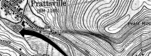
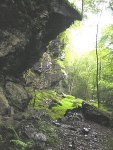
We are guessing that, almost every day, you drive past roadside outcroppings on your routine travels. And we are guessing that you rarely take much notice of them. They are, after all, just rocks. Well, we are in the business of noticing outcrops and sometimes they are quite interesting. We saw one recently on our way home from an event in Prattsville and it was very stimulating. You take Rte. 23 east from Prattsville and turn left where the highway heads toward Windham. Go north about ¾’s of a mile and there it is.

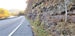
The upper reaches of the strata are fairly run of the mill Catskill sandstones. We didn’t find them all that interesting; it was what we saw below that caught our attention. There, we found about ten feet of poorly stratified, shaley rocks. We are just a little bit uncomfortable in using the word “shaley.” Proper shales are horizontal strata which are also thinly laminated. These were horizontal enough but gently crinkled. Most shales are also usually black or dark gray; these strata were brick red. One of us tugged on his beard; the other furrowed her brow. Both of us were puzzled.

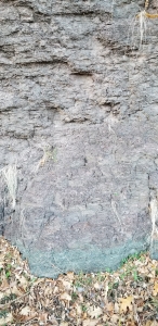
Then it all got worse; at the very bottom of the outcrop the strata were green, not a bright green but a strong enough hue. We could not help but to take special notice of this seemingly out of place color. Green is a rare tint in Catskills strata. But, no matter, red and green it was; there had to be an explanation for these perplexing colors. There was.

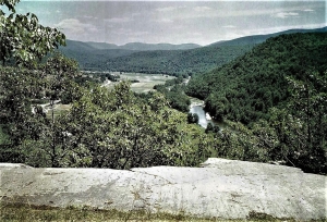
Geologists, all around the world look at red strata and reflexively react by uttering the word “terrestrial.” Brick red is the typical color of terrestrial sediments, especially in tropical landscapes. We knew that all these deposits had formed on something called the Catskill Delta. And we also knew that way back then, during the Devonian time period, that delta had lain about 20 degrees south of the Equator in a definitely tropical setting. This outcrop was a partial cross section of that delta, but could we be a little more specific?

We at first wanted to call these red strata paleosols – that word means fossil soils. But we were uncomfortable with that term, fossil soils are usually a good bit more structured than these were. They often display the kinds of A, B and C horizons of typical soils. Ours didn’t, so what was it? Once again beards were tugged, and brows were furrowed. Our final answer involved just the least bit of waffling; we called all this an overbank deposit, not a soil. These fine-grained strata had been deposited as some sort of floodplain sediments and then only just a few soil forming processes began.

All this led to our final story which took us back to a time of drought on the Devonian Catskill Delta. Those floodplain deposits had dried out, exposing them to a lot of oxygen. That oxygen combined with iron to form an iron oxide mineral called hematite which is brick red. That colored the future rocks. But, even during a bad drought, there would still be some water deep in these soils. The water table had been about eight feet deep and down there, without much oxygen, the soils turned green.

So, we have what scientists call a hypothesis to explain what we see along the road. A hypothesis makes sense and is consistent with the evidence. But we are not absolutely sure that we are right and that is why we can’t yet call it a scientific theory. Hypothesis or theory: there is a difference. We don’t know which but still, it is a nice story.

Contact the authors at randjtitus@prodigy.net. Join their facebook page The Catskill Geologist.”


Pratt Rock – Its glaciers

in Uncategorized by

A glacier at Pratt Rock

The Catskill Geologists

Robert and Johanna Titus

We were happy to read in the Mountain Eagle of plans for the upcoming restoration of Pratt’s Rock. It’s quite an unusual location; it’s been there a long time and does need an upgrade. We look forward to seeing what will happen, and we hope, when things are done, there will be some appreciation for the geological heritage of this fascinating rock.

Had all gone to plan then Zadock Pratt would have had quite the Mausoleum up there, but that did not happen. Nevertheless, Pratt does have an impressive monument. Probably most all of you have visited it. Many of you have climbed up and seen closeup the carvings that are there. There is still a chamber where Pratt planned to be buried. Then there is the poignant image of Pratt’s son George who died at the Civil War’s Second Battle of Bull Run.

None of this would have or could have been if there had not been such a steep slope there to begin within. Take a look at our first illustration; it shows a topographic map of Pratt’s Rock. Can you “read” contour lines? Then you will recognize the steep Pratt Rock slope from the closely spaced contours. It’s nearly a cliff and it faces the valley of Schoharie Creek which flows through Prattsville. Ledges of Catskill sandstone tower above the valley. A ledge is just a ledge, isn’t it? Well, not where we come from; we are geologists, and we know there is a deeper story here

We hike up to the carvings and then continue onwards to a ledge that offers a fine view of the valley. See our second illustration, a photo of that ledge. Notice the smooth surface and the sharp drop-off of the ledge; there is a cliff there. Less obvious, but quite important, are the scratches on that surface. There is a lot of ice age history here. We look and we see what is called the Schoharie Creek glacier passing by. It has flowed south, swelled up to fill the valley and passed across this sandstone. The ice carried a lot of sand with it, mostly concentrated at its dirty bottom. That sand acted as sandpaper and produced the flat surface. There was more, the glacier carried cobbles and boulders along with the sand. They were dragged across this surface and that produced those scratches which geologists call striations. Knowing this, now you can see that they parallel the glacier’s movement down the valley.

What about that cliff? That’s all part of the same story. Glaciers can be sticky. A glacier, when it passes across a mass of rock such as this, forms a tight bond with it. The glacier continues its journey south, it exerts a tug upon that rock. It is quite possible that the tug will break loose a mass of rock and yank it loose. That’s what happened here. There is nothing unusual about this; we geologists see such things frequently. It has a name; we call it glacial plucking. We stand at the top of this cliff, look down the valley and know that somewhere down there is all that missing rock, buried in the floodplain.

Well, the story we have just related, goes a long way to explain how it was that Pratt’s Rock came to be. It started out as an ice age feature. But there is a lot more to this story. Let’s continue next week.

Contact the authors at randjtitus@prodigy.net. Join their facebook page “The Catskill Geologist.”

A Plowed Field -Sep. 12, 2024

in Uncategorized by

Geology of a plowed field?

The Catskill Geologists; The Mountain Eagle – Oct 25, 2019

Robert and Johanna Titus


We are not farmers, so we don’t know why farmers plow their fields at this time of the year. But, as geologists, we do know what to look for when they do. In fact, it is not unusual for us to slow down and take a good look at a newly plowed field; Whatever are we looking for? Well, not surprisingly, we are exercising our trained eyes. And today, we would like to help you do the same.

Recently we were driving south, down Rte. 9G toward Hyde Park, when we saw the freshly plowed field in our first photo. Take a look; what do you see? Or, rather, what do you not see? We always like to say “the hardest thing to see in science is that which is not there. Take another look at our photo: what is not there? You are probably going to kick yourself when you miss this.

The answer is that there are no rocks lying on the ground. Isn’t that just a little strange? What happened the last time you did some digging? You probably hit “two rocks for every dirt,” right? So, what happened to those two rocks? Actually, they were never there. It turns out we had been driving along an old glacial lake. Lake deposits are almost all silt and clay. There are no rocks. That glacial lake has a name; it was Glacial Lake Albany and, back at the end of the Ice Age, it flooded much of the Hudson Valley, including our location along Rte. 9G. Its waters are long gone; they drained away. But the old silts and clays are all still there. One way to identify them is to wait for plowing and watch for that absence of cobbles. We like to pull over, get out and, in our mind’s eyes, gaze at the lake that we and perhaps only we, can envision.

Let’s take you to another location along the highway, Rte. 9, just south of Rhinebeck. Now your newly trained eyes probably won’t have much trouble in seeing what is there: rocks, and lots of them. What happened here? Why is this so different? This is another wide flat landscape, and you might be tempted to interpret it as another old lake bottom. But, don’t forget all those silts and clays of lake bottoms. This flat surface is quite likely a floodplain. Flood plains often are stony like this one. Floodplain deposits are generally deposited by flowing river waters. There are a lot more floodplains on his planet than glacial lakes so there is no surprise here.

So, why are we talking about sediments east of the Hudson; that’s pretty far away. Well. don’t forget we are here to train your eyes. We would like it very much if you began paying attention to flat landscapes, especially when they are plowed fields. There will be a lot of them come next spring, and that likely includes places around where you live.

Contact the authors at randjtitus@prodigy.net.  Join their facebook page “The Catskill Geologist.”

Fun Fest at Cathedral Gorge Sep. 5, 2024

in Uncategorized by

A Family Fun Fest at Cathedral Gorge

The Catskills Geologists; The Mountain Eagle; Oct. 2019.

Robert and Johanna Titus


Our grandchildren are getting older now and they live so far away. We don’t do as many things with them as in the past. It’s been a pleasure to watch them grow up, but we do miss past activities. One of those was going to the Fall Family Fun Fest at the Ashokan Center in the town of Olivebridge, adjacent to the Ashokan Reservoir. The Center is an outdoor education organization run by famed musicians Jay Unger and Molly Mason. You might remember them for the music they composed and played for several of Ken Burns’ programs on PBS. The Center has a 385-acre campus and schedules frequent residential and day programs about the natural sciences along with equally frequent music and dance camps, concerts and art exhibitions. We sometimes find ourselves down there even without grandchildren.

This year’s (2019) Fun Fest will be on Sunday, Oct. 20. Family fun is just exactly that: There will be food, crafts, apple cider making, pumpkin painting, face painting and of course music by Jay and Molly and friends. There will also be nature hikes and that is where the geology comes in. We have known Jay and Molly for years and they, long ago, encouraged us to explore Cathedral Gorge, the scenic centerpiece of the Ashokan Center. Cathedral Gorge is just as scenic as its name implies. It witnesses the flow of the Esopus Creek through a rock walled canyon for quite a downstream distance. And you even have to cross an old covered bridge to get there.

We were invited to come down there last summer and lead their team of outdoor educators through the gorge. They wanted to learn its geological history so they would be able to include that when they lead groups on their own. And that will include Family Fun Fest. You can go for a guided tour down the gorge at 11:00 or at 3:00.

We don’t want to spoil anything but let’s talk just a little about what you are going to see. You won’t go far before you are likely to notice that Cathedral Gorge is called a gorge for a good reason. Esopus Creek, right there, is indeed squeezed into a steep rock walled canyon. It’s so easy to dismiss such a thing as just being a pretty landscape. But our columns have, all along, been aimed at training your geological eyes. When we look at such a landscape, we also look into its past. We know a thing or two about Esopus Creek. That creek has had its moments in time–geologic time.

Once, perhaps about 14,000 years ago, there was a great ice age lake filing most of the Schoharie Creek Valley. The lake rose up so high that it began draining through Stony Clove and down Stony Clove Creek and on into the Esopus Creek. As the glaciers were melting, that flow accelerated to become a huge torrent. Pause on your tour of Cathedral Gorge and look upstream. Imagine how much water was cascading down this canyon at just that moment. It’s quite an image. Powerful flows must have nearly filled the canyon. And it provides us with an explanation of how Cathedral Gorge got to be there. It was eroded by this flow.


Contact the authors at randjtitus@prodigy.net. Join their facebook page “The Catskill Geologist.” Read their blogs at “thecatskillgeologist.com”

Go to Top