A glacial lake at Prattsville
The Catskill Geologists; the Mountain Eagle, June 21, 2019
Robert and Johanna Titus
We are pleased to hear that Pratt’s Rock will be refurbished. A sizable sum of money has been set aside to repair the site in the “same spirit of Zadock Pratt.” Pratt’s Rock, long regarded as the “Mt. Rushmore of the east,” has always drawn thousands of people to the town. They walk up the trail there and explore the sculptures. It is hoped that the numbers of tourists will increase with the restoration.
We have climbed the rock and have always enjoyed visiting but, for us, there is more there than just the carvings. Last week we wrote about the effects that advancing glaciers had on the site during the Ice Age. We saw that the steep slopes of Pratt’s Rock were the products of the ice passing across this hill and plucking masses of rock out of the ground, leaving a near cliff behind. Much of Schoharie Creek displays similar cliffs and they formed in the same manner. But glaciers did not just advance; they also melted back. When they did, they left other ice age features.
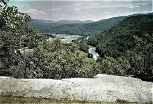
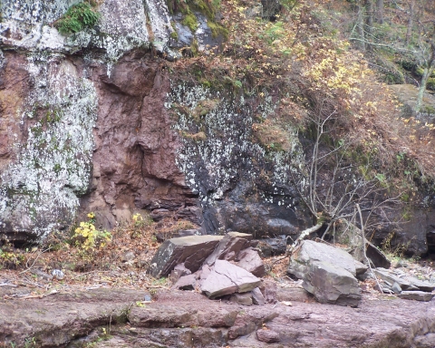
Take a look at our first photo. It shows the top of that plucked cliff. That advancing glacier passed across it and smoothed it into form we see today. A lot of rock was yanked out of the ground, leaving a cliff behind. We talked about all this last week. But look again; in the distance is a flat valley floor. That should simply be a floodplain. Right? Well, wrong; this is the floor of a glacial lake that was once down there. It has a name; it is Glacial Lake Grand Gorge.
Here’s what happened: Something called the Schoharie Creek Valley glacier advanced southward almost to Lexington. It came to a halt there as the climate started warming up. Great masses of earth had been bulldozed toward Lexington and left behind when the ice melted back. This was sediment that served as an earthen dam so that the retreating glacier left lake waters. Lake bottoms accumulate great quantities of silt and clay as lake deposits. Lake bottoms are always flat and that is what we see in the distance from the top of Pratt’s Rock.
If you go down there you can prove this for yourself. Bring a barbeque skewer and try to drive it into the ground. Throughout most of the Catskills skewers won’t go very far into the ground; they will hit rocks or pebbles. But down there, east of Prattsville, those lake deposits are all silt and clay; a skewer will always slide easily into the ground.
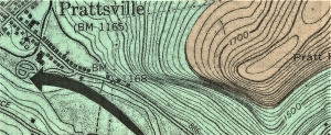
This was a big lake and deep too. Take a look at our second illustration. The lake level is thought to have been about 1,600 feet in elevation. Prattsville is at about 1,165 feet so the lake was more than 400 feet deep. When we stand atop that ledge, we always see the image of Lake Grand Gorge spread out before us; it’s quite the sight.
We hope that, as part of renovations, a path to this ledge will be marked. Perhaps a placard can be placed there with an explanation of this ice age history. It’s an important part of the Pratt Rock heritage.
Contact the authors at randjtitus@prodigy.net. Join their facebook page “The Catskill Geologist.” Read their blogs at “thecatskillgeologist.com.”