"I will never kick a rock"

Monthly archive

May 2018

The Poison Sea May 31, 2018

in Uncategorized by


THE POISON SEA – Or Dog days of the Devonian


THE KAATSKILL GEOLOGIST

Kaatskill Life, Summer 1994

Updated by Robert and Johanna Titus


THE CATSKILLS rarely have a season of “dog days”, the time of hot, humid, heavy, stagnant air. That weather is the lot of more southerly climes. Up here, more often than not, our summers are nearly ideal: warm, dry and pleasant. However, that was not always the case. The rocks contain the record of a very different time in the history of our region, a very long time of perpetually unpleasant summer.

Drive along U.S. Route 20, in the vicinity north of Cherry Valley, and you will see some remarkable strata, the jet-black shales of a unit of rock called the Marcellus Group. All sedimentary rocks represent ancient environments, but it usually takes a while to decipher their


history. The Marcellus communicates its story as soon as it is seen. Its strata are thinly-bedded sedimentary rocks which were once the mud of an ancient ocean’s sea floor.
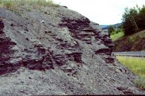
Robert last visited these rocks late in March with his stratigraphy class. At the time, a late winter snow flurry was approaching. In the cold cloudy sky, the Marcellus is an almost sinister looking sequence of rock: dark, forbidding and mysterious. And that’s exactly what it once was because the Marcellus records the history of the “poison sea” which once covered the western Catskill region.
Courtesy of the New York State Museum

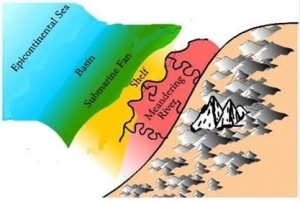
It was the geography of the time that made the poison sea. The Catskill vicinity then lay in tropical latitudes so that the climate was quite warm, and so was the ocean. The ancient Acadian Mountains blocked the weather patterns which otherwise would have approached, riding through on the easterly trade winds. That’s the important part. You see, with the weather patterns blocked, there was relatively little wind blowing across the Catskill Sea and thus few currents to churn up that ocean. West of the Acadian Mountains, the sheltered sea became a hot, stagnant “soup”.

We can visit similar seas today. The Black Sea, though not on the equator, is a good example. Being land-locked, weather patterns do not much affect the Black Sea. The waters of such seas are usually stratified. Although the surface waters are very warm, they do contain a lot of oxygen and sea creatures can and do flourish in these shallow waters. It is different below; there bacteria consume all of the oxygen and the sea water becomes anaerobic, making it poisonous for any creatures who may wander in. They don’t; these waters are lifeless.

Such conditions persist right down to the bottom. As is normally the case with oceans, mud accumulates on the sea floor. The mud of oxygen‑poor seas is always jet black in color and, when it is compressed and hardened into rock, it becomes black shales. That’s how the Marcellus black shales formed.

Meanwhile, at the surface of the Catskill Sea, conditions were different. There was plenty of oxygen and a flourishing community of marine life. Masses of floating algae, with many small animals, thrived in a rich planktonic ecology, an oceanic jungle. Today we often call such a marine community a Sargasso.

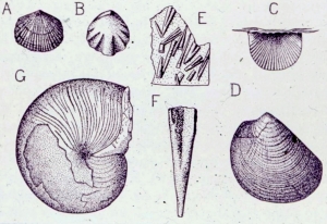
Floating creatures seldom have skeletons and so they are rarely preserved as fossils. Consequently the Marcellus shales display only a few fossils for the careful hunter to find. Back in the 30’s Winifred Goldring, a paleontologist with the New York State Museum, studied the Marcellus and published some fine illustrations (figure three). Among her specimens, three (A, B and C) are tiny shellfish called brachiopods (brachs for short). Brachs will remind you of clams but they aren’t; they are an entirely separate group of shellfish. One specimen (D) is a clam. Notice that brachiopod shells have symmetry and the clam’s shell doesn’t. Pictures E and F are a puzzle. These creatures, called styliolinids, are extinct and we don’t know what they were. That’s a common problem with rocks this old. All of these invertebrates were small and lightweight. They could float in the surface waters of the poison sea, drifting as plankton or attached to floating wood or seaweed. Specimen G is different; it was an active swimmer. We call it a nautiloid and its descendants are still alive. The chambered nautilus, of the south Pacific, is today’s living nautiloid. Closely related to squids and octopods, the nautiloids had tentacles and well-developed eyes. They were active predators, swimming in the surface waters of the poison seas.
You can visit the shales of the poison sea yourself. From Cherry Valley, take county Rt. 166 northeast to Rt.20. Head west on 20 about half a mile and look for the shales on the north side of the road. You can see a better exposure if you head east on Rt. 20 and travel 2.6 miles, where you will reach Chestnut Street. There you will find an outcrop with two units of shale separated by about five feet of gray limestone.

If you patiently pick through the shales, you will certainly find many styliolinids; watch carefully as they are very small. With luck you may find some of the other fossils as well. I have seen some very fine fossil snails below the limestone at the eastern outcrop. That limestone can also be a lot of fun too. This unit represented a temporary break from the poison sea conditions. For a period of time a shallow, oxygenated, tropical sea prevailed here. The limestone has a number of fossils in it, typical of such seas.

The poison seas are misnamed; there were never any active toxins in them, just an absence of oxygen. Nature does that from time to time. The lesson we learn from the poison seas is not that nature creates inhospitable environments, but that she allows life enough time to adapt to her conditions. The planktonic creatures of the Marcellus black shales thrived just a few feet above one of nature’s most inhospitable environments.

*      *      *

Visiting the Marcellus shales is not the same as seeing the poison sea itself. To do that, pick one of those hot, humid but clear summer days and, in the stillness of the early evening, find a vantage point looking down upon the valley of the Mohawk. The Chestnut Street site may do. From here you can still see the entire expanse of the old poison sea, stretching from the eastern to the western horizons. You are a little above the old sea level, and the atmosphere is just as it was back then.

The summer sun is setting in the northwest and, as it approaches the horizon, the valley of the Mohawk darkens and flattens into a land of somber colors. The fields become a brownish, algae green; the forests turn jet black. To the northwest, the horizon becomes the image of a very still sea. Back to the east there is a distant bank of clouds. As this eastern horizon darkens, those clouds sharpen into the clear vision of the peaks of the ancient Acadian Mountains. Distant mountain ranges often masquerade as clouds, and there is always a shock of surprise when one recognizes the illusion. The lower Acadian slopes are a dark blue brown; they are already in the shade. The jagged pinnacles are small brilliant pyramids; they still reflect the sun.

The air is absolutely still and the surface of the poison sea is as flat as water can be. Gauzy clouds of green algae alternate with bottomless pools of black waters. Occasionally, bubbles of fetid gas rise to the surface and oily dots mar the blackness. Only these betray the suffocating gloom in the depths below. Small, delicate wakes encircle the green; unseen predators are hunting unseen prey. Now a few swells pass heading westward, waves reflected off the distant coast. The green patches lazily drift back and forth in these oceanic breezes. Abruptly there is a disturbance, a quick splash and, for a split second, a mass of tentacles, a single eye and then a brown and white striped shell are seen breaking the water.

Quiet quickly returns as the sun sets and the sea darkens. The evening stars now appear and they seem to be reflected on the glassy sea below. But these reflections gradually blur, and they enlarge into luminous patches of light. Phosphorescent plankton are completing their evening ascent. Their dim glow is all that will light the dark of this Paleozoic sea.

In the growing dark, the image of the poison sea dims. The bioluminescent patches shrink and sharpen into yellow pinpoints of light. Far below, the electric lights of the Mohawk Valley are coming on and now it is they which reflect the stars above. The poison sea is gone, long gone, just an image in the eye and mind of the pensive geologist.

   Contact the authors at randjtitus@prodigy.net. Join their facebook page “The Catskill Geologist.”

Sam’s Point in the Shawangunk Mountains May 24, 2018

in Uncategorized by

Visions of a Hudson Valley geological past: Glaciers at Sam’s Point

Watch out for moving ice

Robert and Johanna Titus


The Shawangunk Mountains are certainly among the most scenic locations in our region, and uniquely so. This ridge of resilient quartz sandstone towers above the Hudson Valley. One of its most popular locations is Sam’s Point Preserve, near the south end of the mountains. It’s thousands of acres are perched atop the mountains at elevations well above 2,000 feet. It’s owned by the Open Space Institute and managed by the Nature Conservancy. In the past there were commercial uses of this land. There were abundant blueberries here, and people were hired, every summer, to come and pick them. Then, in addition, there have been several resort hotels.

But we came here to learn about the geology. How had the area’s geological history given rise to this scenic wonder? We headed up the trail. It didn’t take long to figure out why the Shawangunks are even there. All along the trail were massive outcrops of quartz sandstone and conglomerate. Quartz is very resistant to weathering and a mountain made out of such rocks will stand out as all other bedrock around it erodes away.

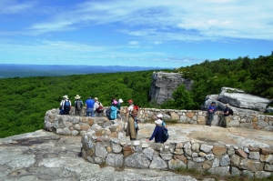
We got up to Sam’s Point itself and soon learned much more about the geological history that went into creating the landscapes we see today. We arrived at the easternmost of two sandstone platforms, each seemingly designed for sight-seeing.  Naturally, we were more interested in looking down at the rocks than gazing at the distant scenic views. There was some special things that caught our eyes.

We saw a polished sheen and faint scratches on the surface of the rock. We quickly recognized these to be common ice age features. Sam’s Point has had a long ice age history, probably going back to the time when glaciers first came down the Hudson Valley. At that time this site had ice passing across it. The ice was dirty, carrying a great deal of sand along with it, mostly concentrated at its base. The sand, probably mixed with a lot of silt and clay, actually polished the bedrock. It sanded it down and planed it off.

There was more. The glaciers carried with them a large number of cobbles and boulders. As these were dragged across the surface, they gouged scratches into the bedrock. Geologists call these glacial striations. We have seen such surfaces many times so it was hardly a great revelation, but it did speak clearly to us of the fact that there had once been a sizable glacier here. Then we saw more.

We looked up and there was Sam’s Point itself. It is another natural platform of quartz sandstone, but this one is bounded by a vertical cliff, a big one. Most people would enjoy it as a fine scenic overlook, but our eyes took us back into the Ice Age. Geologists call features like Sam’s Point scour and pluck topographies. These are common and each is the product of the passage of the ice. The Hudson Valley glacier advanced from the north and, as it crossed Sam’s Point, it scoured and striated that platform at the top of the cliff. That’s the scour part. Then, as the ice continued south, it stuck to the bedrock and then yanked enormous masses of it loose and carried them off. That left gaping scars in the mountaintop and one of them is the cliff of Sam’s Point. That is also the pluck part of this landscape. The cliff faces a compass direction of south-30 degrees-west. That, presumably, was the direction the glacier was traveling. We looked at the striations beneath us, and we had a compass. They had the same orientations.

Now we had a nice, coherent explanation for the topography of Sam’s Point. That’s what scientists call an elegant solution to a scientific problem. We would have been flushed with pride at having made such marvelous discoveries, were it not for the fact that thousands of other geologists had preceded us here, and they had, no doubt, all come to the very same conclusions.

Reach the authors at randjtitus@prodigy.net. Join their facebook page “The Catskill Geologist.”

The Mountain House ledge May 17, 2018

in Uncategorized by

Visions of a Hudson Valley geological past: “The Mountain House Ledge.”

Robert and Johanna Titus


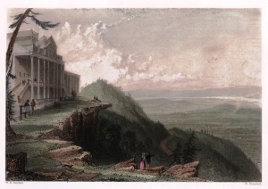
Certainly one of the most historic sites in all the Catskills is the Mountain House ledge at North/South Lake Campground. We are betting that most of you have been there. It’s a grand, broad shelf of sandstone, jutting out 2,000 feet above the floor of the Hudson Valley. It’s claimed that you can view some 70 miles of that valley from this site. It is, of course, the very place chosen for the building of the Catskill Mountain House Hotel, back in the 1820’s. That was the grandest of the grand hotels of the Catskills during our region’s most fashionable era. The hotel attracted a Gilded Age aristocracy; a Who’s Who of the American elite vacationed there. But something spiritual happened here too. America came to love nature at this location. It was here that the Hudson Valley School of art was born, when Thomas Cole spent a summer sketching the scenery. Almost equally distinguished was the poetry and prose that was inspired by this “sublime” wilderness landscape.

There is no way to overestimate the historical heritage of these few acres of land. The whole culture that we equate with the word Catskills had its birth at the Mountain House. And the hotel had its birth on this scenic ledge. It is one of our favorite places. We frequently go there and just sit upon the ledge’s rocks. We touch the sandstone and look around. All that lies above the ground, above those rocks, belongs to history. Here historians such as Roland Van Zandt and Alf Evers prevail. They explored the past at this site and recorded its many influences on our modern culture.

But, we touch those rocks again. Everything below the ground belongs to us! All around is the historical heritage of modern Catskills culture but below is a geological past that reaches back hundreds of millions of years. Nearly four miles of sedimentary rock lies beneath us – right here. And, down there, every stratum of rock has its own history, from its own time.

We touch this ledge and contemplate its petrified sand. It accumulated on the floor of a river channel. That was during the Devonian time period, about 380 million years ago. A river flowed by, right here, and then it disappeared off to the west. We gaze west and then turn around and look, more intently, eastward hoping to see where that stream and its sand came from. But . . . there’s nothing there but the great emptiness of the valley.

Suddenly, we are time travelers; around us it is the Devonian time period. We are just above the waters in the middle of that stream, looking east. To our left and right are the river’s low banks. Rising above them are Devonian trees, at least they must be trees; they are so exotic, so strange in appearance. Frail looking trunks rise 25 feet above the banks. There are no branches, not until the very top is there even any foliage. All this defies all efforts at description. There are no leaves, just things that might be called fronds. But even that term does not suffice. These are among the most primitive “trees” known to science. They represent evolution’s earliest efforts at the very concept of a forest, and Devonian evolution has not yet become very good at that. If these trees defy description, it’s because nothing like them grows today.

We turn and look east. In the distance a mighty mountain range towers above that horizon. We quickly realize that the Taconic and Berkshires of today are but the roots of this ancient mountain range. Their middle slopes are gun metal blue and cut by many enormous ravines. Above the blue is a horizontal white snow line. High above that are the white peaks of this enormous range.

Our journey into the past is a brief one. Soon we sit again upon the Mountain House ledge and see our modern landscape. We have beheld its geological heritage.

Reach the authors at randjtitus@prodigy.com. Join their facebook page “The Catskill Geologist.”


The Greenport Mastodon May 10, 2018

in Uncategorized by

The Greenport Mastodon

Windows Through time

Feb. 28, 2013

Columbia Greene newspapers

Updated by Robert and Johanna Titus


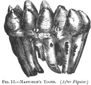
Our topic today will be one of the most notable paleontological discoveries ever made here in our region: the finding of the first mastodon. This was a big find and was made a long time ago: way back in 1705. That’s when a Dutch colonist found a huge tooth in a bank of clay along eastern bank of the Hudson in Greenport. It weighed almost five pounds and our Dutchman must have been most impressed. Not so impressed, however, that he was not willing to sell it for a half gill of rum (two ounces) to a local assemblyman.

The tooth worked its way up the political food chain to Lord Cornbury, then Governor of the New York Colony. He sent it off to the Royal Society of London. Today, that would be like sending it to the Smithsonian Institute. The tooth attracted a lot of attention in London, and from just the right people.  In 1705 not much was known about prehistoric monsters, in fact very little was known about prehistory. The scientists of the time were puzzled.

There were two hypotheses. Some thought that the tooth belonged to a remarkable beast or fish, but they could not imagine what type of creature it had been.  Lord Cornbury and others had another idea; the tooth belonged to a “giant” and they were talking of a biblical giant, referred to in Genesis 6:4. This tooth, they thought, had belonged to a huge human being!

To his credit, Cornbury sent people to search the original site for more skeletal remains and they found parts of a very much decomposed skeleton. They estimated that the beast had been 70 feet long. In fact, they had greatly exaggerated its size, but you can imagine how they reacted to the very notion!

From the beginning there were others who speculated that the remains belonged to an elephant, but what kind of an elephant and how did such an animal get to the Hudson Valley? For the second part of the question, here again, contemporary religious views offered a solution: the beast had been carried here by Noah’s Flood. That would be difficult to prove, but it was an appealing idea.

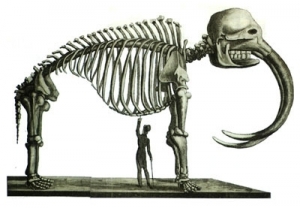
It would take decades to solve the other half of the problem – what kind of elephant had it been – and that came when many more mastodon bones were found in the Ohio River valley, and a complete skeleton was unearthed in New York’s Orange County. Now, at last, scientists could see a whole skeleton with tusks, and clearly its bones were those of an elephant, or at least a distant cousin of today’s elephant. But only a distant cousin; now there was a new scientific problem. The mastodon did not match the Indian or the African elephants; it was a separate and new species.

But nobody had ever seen such a creature in the wild. That was still another problem. At this time the very notion of extinction was a new and very troubling concept. Could mastodons have once lived and then gone extinct? Not many people were comfortable with that thought. Theologians, especially, argued that no such thing could have happened; God would not allow extinction of species he had created. Perhaps but, if so, where were the living mastodons?

That was a serious scientific question in the early 1800’s and President Thomas Jefferson, an accomplished amateur scientist in his own right, thought he could solve it. The Lewis and Clark expedition was soon to head west, and Jefferson specifically asked its members to be on the lookout for mastodons. Certainly the animals were extinct here in the east, but perhaps they still lived somewhere out there beyond the Appalachians.

Well, Lewis and Clark found a lot of things all across America, but they never saw an elephant. The results were clear: mastodons were extinct and, like it or not, extinction was something that really could happen – and really had happened.

All this adds up to some very important early progress in the science of paleontology. Our Greenport mastodon was among the very first prehistoric monsters to be discovered. Later generations would discover the dinosaurs, but these great mastodons are still quite something to contemplate. All this would lead, with time, to a great understanding of the exotic nature of our planet’s paleontological history; this was one of our first glimpses into life’s distant past.

But, equally important was the introduction of the very concept of extinction. We take that for granted today but it was a most remarkable, and disturbing, discovery three centuries ago.

Reach the authors at randjtitus@prodigy.net. Join their facebook page “The Catskill Geologist.” Watch for more articles in Kaatskill Life, the Woodstock times and the Mountain Eagle.


The myth of Spook Rock. May 3. 2018

in Uncategorized by

The Myth of Spook Rock

Stories in Stone

The Columbia County Independent; Nov. 23, 2004

Updated by Robert and Johanna Titus


MAYBE YOU READ the Independent’s recent (2004) review of Pasquale Morrone’s book “Spook Rock.” It’s a work of fiction based on a mythology. That, of course, is not something that usually attracts the attention of a scientist. We don’t devote a lot of time to myths, but in this case we think that we can be forgiven. Morrone’s book is centered on a real rock and we always like a rock with a good story. Spook rock is located south from Rt. 23B on Spook Rock Road where it passes very close to Claverack Creek.

The legend has it that, long ago, an Indian maiden fell in love with the son of a chief of another tribe. Her father, also a chief, predictably, did not approve of this. One thing led to another; the two lovers met in the darkness at Claverack Creek.  Great. A  great boulder was hit by lightning and fell from the cliff above and landed upon them. They ended up crushed to death. The rock is still right where it fell and, presumably, the unfortunate lovers remain beneath it. Stay away on full moon nights!

Naturally, we could not resist going and seeing such an ill-mannered rock. It’s easy to find; it lies near the western bank of the creek, conveniently close to the road and there is very good parking. Unfortunately, we had to wade out to it. Our first scientific discovery was that spook rock has many very sharp corners to it and these are hard on bare feet.

We quickly recognized the rock; it is a piece of what we geologists call the Devonian aged (about 400 million years old) Manlius Limestone. That’s a type of rock that makes up a sizable portion of Becraft Mountain. With this, we had confirmed one important element of the myth. This rock certainly had tumbled down from the Manlius Limestone ridge above.

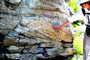
But soon another story began to emerge. We looked at the gray limestone and saw many thin laminations within it. We knew what these were; they are called algal laminates. Geologists have long recognized these laminations as being the fossils and ancient algae. You see, some colonies of very primitive algae grow into sheets on tidal mudflats and coat the surface with their own stickiness. As the winds and the tides rise and fall, grains of silt and clay adhere to the sticky algae and thus the laminates come to form. We looked at this and we were transported through time.

June 10, 400,002,000 BC, high noon. All around us lies a bleak flat landscape. To the west, quite some distance away, we can see an ocean. It is a beautiful aqua color. This is a peaceful sea, with virtually no waves breaking on its distant shore. It’s called the Helderberg Sea; we have been here many times before and knew what to expect.

At this distant time, Columbia County lies very close to the equator, and at this noontime hour an intense tropical sun beats down mercilessly. In short, we have arrived at a bad time. To make things worse, the Devonian age atmosphere has much less ozone in it. Today ozone shields us from ultra-violet radiation which minimizes the threat of sunburn. We feel the difference; we would not be able to stay here long before we were seriously sunburned.

All around us lies a sticky mat of dark olive colored algae. These creatures should, like us, have been baking to death in this awful sun, but they weren’t. They belonged to a breed of algae called the blue-green algae, and by the time of the Devonian they are a very old type of microbes. They have been on earth for three and a half billion years and in that time they have evolved a tolerance for intense sunlight. This noon time will pass and they will be just fine.

A wind begins to blow and soon it picks up. Now billowing clouds of dust are blowing from the highlands to the east. The dust coats the sticky algal mats and they turn white. Another lamination is being added to the countless numbers that lie below. If they are turning white, we are turning red. It is time for us to escape the Devonian and return to Claverack Creek as it is today.

Contact the authors at randjtitus@prodigy.net. Join their facebook page “The Catskill Geologist.” Read their columns in the Mountain Eagle.
 

Go to Top