"I will never kick a rock"

Monthly archive

October 2023

Catskill bluestone Oct 26, 2023

in Uncategorized by

What is Bluestone?

The Catskill Geologists; The Mountain Eagle 10-16-18

Robert and Johanna Titus

It would be hard to find a topic more emblematic of the Catskills than bluestone. It’s a stone that has been quarried hereabouts for nearly two centuries. It has mostly been fashioned into sidewalk slabs, but it has a large number of other uses as well. You can probably easily conjure up images of bluestone sidewalks in your mind’s eyes; there are so many of them still around. Then, you can probably also recognize buildings and churches made of the stuff. But just what is bluestone?

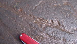
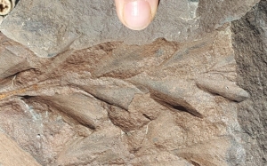
Bluestone is composed of large slabs of sandstone. Those sandstones are horizontally stratified, and, because of that, brawny quarrymen were able to excavate it and, using large sledge hammers and chisels, break it into those slabs. These were then shipped off to locations all over the eastern United States. Bluestone sidewalks last very long amounts of time. Also, they were skid resistant when it rained and, we think, very good looking. No wonder they were so popular. Are bluestones truly blue? We have always had a hard time finding bluestone that actually is “blue.” We understand that whatever blue there is comes from some of the clays that make up small components of these sandstones.

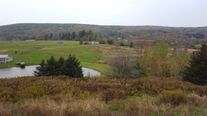
But, we still haven’t answered the question “what are bluestones.” Doing that means that we will have to travel back in time about 380 million years and visit the Catskills region as it was back then. It you have been reading our columns then you know that this was the Devonian time period and, back then, the Catskills region was an enormous delta. Rivers flowed across this, the Catskill Delta, and sands were deposited in their channels.

Flowing water picks up sand and moves it along. Depending on exactly where in the channel those flows are, governs just how fast the currents flow. Typically, one side of the stream sees the fastest flow while the other witnesses the slowest. Strata on the fast-flowing side are recognizably different from those of the slow side. We should talk about those deposits in future articles, but our focus today is on the middle of those petrified streams; that’s where the bluestone formed.

The middle of those Devonian streams accumulated those flat lying strata of sands. It was those that eventually hardened into the flat lying strata that make good bluestone. Some of those streams were a lot bigger than others. It was the largest of those streams that accumulated deposits thick enough to form bluestones that were commercially valuable.

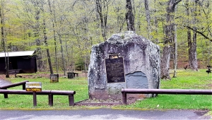
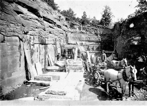
Bluestone quarries were developed all across our mountains, but they were especially common in the Eastern Catskills. Quarrying was most active in the late nineteenth and early twentieth centuries. All the old, abandoned quarries are still there and they provide geologists with wonderful keyholes into our mountains’ Devonian past. We enjoy visiting them and exploring what they have to show us.

There still is an active bluestone industry but is mostly in the western parts of Sullivan County.

==================================================================

Contact the authors at randjtitus@prodigy.net. Join their facebook page “The Catskill Geologist.”

A Delta in Davenport Oct. 19, 2023

in Uncategorized by

The Davenport Delta

The Catskill Geologists; Robert and Johanna Titus

The Mountain Eagle; Mar. 23, 2018


Did you ever take a good earth science course – in high school or college? Well, one of the things that commonly comes up is the structure of a delta. Deltas form when rivers or creeks flow into bodies of still water, oceans and lakes. The flowing water currents almost always carry a fair amount of sediment in them. That’s mostly sand, silt and clay. When those currents enter into a lake or ocean they generally slow down. Slow currents can’t carry as much sediment, so a lot of it gets deposited in the form of a delta.

Large rivers, flowing into oceans, tend to form large deltas. Think of the Mississippi Delta. Small creeks, flowing into your town’s skating pond, create small deltas. Big or little, deltas all have pretty much the same basic structure. The advancing front of the delta displays a steep slope that forms the delta’s outer edge. The sediments of this part of the delta display an inclined stratification. Those strata dip toward the lake bottom. The top of the delta receives sediments that are deposited on a flat plane. Those strata are horizontal.

Those inclined strata are called the foreset beds and, on top of them, are the horizontal strata of the topset. The adjacent lake bottom or sea floor, just beyond the foreset, receives a little more sediment, again deposited in flat stratified horizons. These are the bottomset deposits.

Well, in the end, a delta has a flat topset, a flat bottomset and a relatively steeply sloping foreset in between. Here’s the problem; deltas are underwater so we can’t see any of this. But, what if the lake drains, sometime after deposition of the delta? Then that delta would be left high and dry. We can read your minds right now: how can such a thing happen. Lakes don’t drain away, so the deltas will never be visible. Right?

Maybe – or maybe not.

Take a good look at our photo. It was taken just a short distance east of Davenport Center, looking north along Rte. 23. Close to the center of the photo is a house. Notice that behind it, to the left, is a flat surface. Just to its right is a relatively steep slope. At the bottom of that slope is another flat surface (almost hidden by trees). If you didn’t know better you might think that, arrayed right to left, was the bottomset, the foreset and the topset of a delta. But, of course, that can’t be, can it?

Well, if this is not a delta, then it is one remarkable imitation of one. We have a lot of explaining to do, don’t we? That supposed bottomset deposit, is a flat surface that extends quite some distance off to the east. We have done a little exploring there. Whenever we have climbed down to reach this “bottomset” we bring along a barbeque skewer. A what? Yes, a barbeque skewer; it is a very valuable piece of equipment when we are studying ice age deposits.

We drop down onto what we think is an ice age lake bottom and we try to drive the skewer into the ground. If it slides in easily then we know that there are no cobbles or pebbles in the ground. That is typical of lake bottom sediments. We try again with the skewer, and then again and again. If our skewer keeps sliding in, time after time, then we can assume that our flat surface is indeed the bottom of an ice age lake. That’s always a fun discovery. And, better still, this one was a lake with a delta.

Most of the Charlotte Creek Valley was dammed by melting glaciers at the end of the Ice Age. Lakes formed behind these ice dams and so it was that deltas, from time to time, formed in these lakes. We have discovered one of these old deltas. If you have a chance, go there and take a look; see the landscape there as we do.

Contact the authors at randjtitus@prodigy.net. Join their facebook page “The Catskill Geologist.” Read their blogs at “thecatskillgeologist.com.”

A fossil tree on a trail 10-12-2023

in Uncategorized by

A fossil tree on an ancient trail

The Catskills Geologists; The Mountain Eagle

Robert and Johanna Titus

Dec. 13, 2018


We get a lot of email from our readers and sometimes they send us good leads on potential columns. That happened recently when a reader sent us a photo of a fossil that he found along the trail that leads up to Kaaterskill Falls. Have you been on that trail? It’s been there forever but has been nicely renovated in recent years. It makes a scenic hike. It’s not a difficult one and you are rewarded with a view of Kaaterskill Falls from below. That’s the view that Thomas Cole made famous with one of his first truly successful paintings done in the 1820’s. That view was important in the history of American art itself. If you haven’t been there, then you should.

We have hiked the trail many times and never tire of it. We haven’t had a whole lot of success in finding fossils along it, but they are there. If you have a sharp eye and if your eye is a trained one, then you do find the occasional fossil plant. These are trees from the famed Gilboa Forest. Those are New York Sate’s most important fossils; they make up the world’s oldest known forest ecology, dating back about 380 million years.

We know! We know! December is not a very good time of the year to go fossil hunting, but when the weather warms up, you might give it a try. We, ourselves, have found some fairly decent fossil tree trunks in the massive sandstones of Bastion Falls. That’s right above the highway at the hairpin turn on Rte. 23A. Maybe you can do us one better.

Our reader did just that. He found the branch of a fossil tree, complete with a row of leaves. Take a look at his photo. We immediately recognized the specimen. We had

already seen a very similar specimen in Bearsville. One of our Woodstock Times readers had found it in a quarry above her home. Take a look at our second photo for that one which is a much better–preserved fossil. See how much better the leaves look. We thought that both specimens belonged to a tree named Archaeopteris, but we wanted to be sure. So, we sent both photos off to friend Dr. Charles Ver Straeten at the New York State Museum. Chuck sent them on to two of the most foremost experts on Gilboa trees. They both agreed that these were specimens of Archaeopteris.

Archaeopteris is an important plant in the history of the evolution of trees. It belongs to a group called the progymnosperms.  That is a group of trees just a little more primitive than the gymnosperms themselves. And, as you might know, the gymnosperms include all of the modern evergreens; this is an important group of trees in the history of life.

The trail at Kaaterskill Falls is a scenic one for everyone who enjoys the outdoors, but for the two of us, it takes us back through time to an earlier planet Earth which was witnessing the rapid evolution of trees and of forests themselves.

Do you have good photos of geological wonders? Send them along with descriptions and perhaps we will be able to use them in a future column.

==================================================================

Contact the authors at randjtitus@prodigy.net. Join their facebook page at “The Catskill Geologist.” Read their blogs at “thecatskillgeologist.com.”


Standing Stones 10-5-23

in Uncategorized by

Standing stones – Wisdom of the crowd?

The Mountain Eagle – The Catskill Geologists

Robert and Johanna Titus – Oct 26, 2018


Have you ever seen the Devil’s Tombstone? It’s quite a rock—located at Devil’s Tombstone Campground on Rte. 214 near Stony Clove. It’s right next to the highway and there is good parking, so it is easy to get to. Its peculiar name is easy to explain; the rock looks so much like a very large tombstone. However, we doubt that the Devil is buried there.

Such a rock is often called a monolith. It must be about ten feet tall and a few feet thick. It is composed of typical Catskills bluestone. These strata were once sands at the bottom of a Devonian aged river channel. Now these strata make up a boulder, standing on end. But, what exactly is the Devil’s tombstone? It seems that there should be a story here. Well, actually there are several stories. The first one is the most obvious; it is the notion that humans lifted the rock into its current vertical inclination—perhaps for religious or astronomical reasons.

The monolith notion is what scientists call a hypothesis. A hypothesis is an idea which has been advanced as a possible explanation for a scientific problem. A hypothesis needs to be tested through further observations. As more is learned, a hypothesis begins to look better or, if things go poorly, it can become falsified. After being sufficiently tested, a hypothesis may be elevated in science to the level of scientific theory. In science, the word carries a great deal of worth; a theory is considered the highest level of proof in science; it is viewed with great confidence.

But, in science, it is always thought that many hypotheses are better than just one.  The more, the better. What about the Devil’s Tombstone? Are there other hypotheses or is the human monolith concept the only one? There is at least one other; boulders of this sort can be the products of ice age activities. Advancing glaciers can be easily imagined as picking up and shoving forward boulders of this size. When a glacier reaches its farthest advance, it will halt and, sometime later, begin melting away. A boulder can be left behind, lying in any inclination. Many will lie at angles less than 90 degrees, but a few, logic tells us, should indeed, be at 90 degrees.

So, which is it? Were standing stones all or mostly all put in place by humans or were all or most of them bulldozed and dropped in place by glaciers? Well, before we decide, we have to learn as much as possible about standing stones and that’s where you come in. Do you know of any standing stones? Can you tell us where to go and see them? Do you know of any leaning stones? We need to see these too; in fact, those may be of more importance.

When we know about these boulders, then we can visit them and ascertain their geologic context. If all of them were found with glacial deposits called moraines, then that would be an indication an ice age origin. If most or all, lie outside of glacial deposits then that would be consistent with the human origin hypothesis.

The point is that all of you can find more of them than just the two of us. When we have a lot of them to look at, then we can gather enough evidence to make a good, sound conclusion—a theory.

So, think about it, we need your help.


==================================================================

Contact the authors at randjtitus@prodigy.net. Join their facebook page “The Catskill Geologist.” Read their blogs at “thecatskillgeologist.com.

Go to Top