"I will never kick a rock"

Monthly archive

August 2021

Hurricane Irene in Windham Aug. 26, 2021

in Uncategorized by

Visiting a disaster: Windham

Windows Through Time; The Register Star

Sept. 2011

Updated by Robert  and Johanna Titus


We have all seen the television reports of the enormous disaster that has befallen the Catskills. Hurricane Irene passed straight through the heart of our home mountains and unloaded vast torrents of rainfall upon us. Some of the worst hit areas were in Greene County, especially the towns of Prattsville and Windham. I don’t have rainfall numbers for these locations, but there were about 13 inches of rain in nearby Durham and Hunter, and it was very bad throughout the county. The television coverage was very gripping; it was riveting to see the devastation done to these many towns and the harm done to so many lives.

But it is altogether another thing to go out and visit one of these villages and see for yourself what has happened. My wife, Johanna, and I wanted to go to Prattsville, which was hardest hit than of all, but that was out of the question. Prattsville was too wrecked to let people in. We were able to visit Windham and see what was going on there.

As we approached the town from the east on Rte. 23, we began to see some of what had occurred. Along the side of the highway great ditches had been cut into the ground. Some of them had even scoured into the road itself. I got out and looked at erosion that had, in some places, cut four feet down into the earth, all the way down to bedrock. Now we could see that, at the height of the storm, Rte. 23 was, in effect, converted into a river. That’s common in flood events. The currents had been so powerful that it had turned the ditches into great gullies.

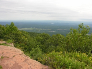
We continued on toward Windham and, to our left, the valley of Batavia Kill opened up. It’s a large valley and, behind it to the east, it stretches into Black Dome Valley. Black Dome Valley reaches eastward and ends in a large bowl-shaped basin which reaches into the high front ranges of the Catskills. The bowl was probably carved by an Alpine glacier towards the end of the Ice Age. Bowl is a good term and accurately portrays what this basin was doing on that Sunday. This bowl began the flood. It was receiving that massive rainfall, collecting it, and passing it on down Batavia Kill – to Windham.

We diverted our trip to visit the village of Maplecrest and there we saw a stunning testimony to the power of the flood that had developed. The bridge at the west end of the village was completely destroyed. In the five miles that the Batavia Kill had flowed west from that bowl, it had already swollen so much that it welled up over its banks and had undercut the bridge, leading to its destruction. Soon that torrent would flow on to Windham. We followed.

????????????????????????????????????

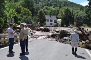
As we entered Windham, we immediately saw the whole effect of the flood. What has to be understood is that, at Windham, the Batavia Kill had not just risen, it had expanded. Most floodplain floods are relatively calm; there are few powerful currents. But what happened at Windham is that the river had become bigger than ever. As its currents had grown more powerful, they had swollen into the town. The Main Street business district was literally located in the middle of a powerful river. And that stream was being fed by the pounding rain in the Black Dome Valley. It was an awful moment.

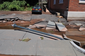
But we got there during the aftermath, the flood had subsided, and people had come out to start dealing with the damage. Folks were not dazed; they were very unhappy, but they had determination on their faces as they set about doing what they could. We saw large hoses emerging from basements, pumping water out of family homes. We saw several cars where they had been lifted up, carried by the flow, and dumped by the flood. Windham had been, and will be again, a pretty town. Part of that is from the bluestone sidewalks, but we saw that the flood had been strong enough to lift up many of those heavy stone slabs and sweep them some distance. Whole stretches of sidewalk had been carried off. We saw lampposts that had literally been bent over by the currents: something frightening just to contemplate.   Storefronts, here and there, had been badly damaged. Many homes had seen their first floors flooded. It was a terrible sight. We were looking at all of Nature’s power.

We asked if we could drive on to Prattsville and were told that no, things were very much worse there. Soon we would start hearing about Martinsburg, Middleburgh, Phoenicia and many others.

Contact the authors at randjtitus@prodigy.net. Join their facebook page “The Catskill Geologist.” Read their blogs at “thecatskillgeologist.com.”


The Mountain House Ledge Aug. 19, 2021

in Uncategorized by

Visions of a distant past, Pt. two –“From the Mountain House Ledge.”

On The Rocks; The Woodstock Times, Dec 23, 2010

Updated by Robert and Johanna Titus


Certainly, one of the very most historical sites and all of the Catskills is the Mountain House Ledge at North/South Lake State Park. We are betting that most of you have been there. It’s a grand, broad ledge of sandstone, jutting out 2,000 feet above the floor of the Hudson Valley. It’s claimed that you can view some 70 miles of that valley from this site. It is, of course, the very place chosen for the building of the Catskill Mountain House in the 1820’s. That was the grandest of the grand hotels of the Catskills during the Catskill’s most fashionable era. Back then a Gilded Age aristocracy visited the site and its hotel. A Who’s Who of the American elite spent time here. But something spiritual happened here too. America came to love nature at this location. It was here that the Hudson Valley school of art was born, when Thomas Cole spent a summer sketching the scenery. Almost equally distinguished was the poetry and prose that was inspired by this “sublime” landscape.

There is no way to overestimate the historical heritage of these few acres of land. The whole culture that we equate with the word Catskills had its birth on the Mountain House Ledge. It is one of our favorite places to visit and we have begun any number of geology field trips and walks right there. But we frequently like to go there by ourselves and sit upon the rocks at the rim of the ledge. We touch the sandstone and look around. All that lies above the ground, above those rocks, belongs to history. Here Roland Van Zandt and Alf Evers prevail. They explored the history of this site and recorded its many influences on our culture.

But we touch those rocks again. Everything from the ground down belongs to us! All around is the historical heritage of culture in the Catskills; below is a geological past that reaches back hundreds of millions of years. More than a mile of sedimentary rock lies beneath us, and every stratum has its own history, from its own time. We touch this ledge and contemplate its petrified sand. It accumulated on the floor of a river channel. That was during the Devonian time period, about 375 million years ago. A river flowed by, right here, and then it disappeared off to the west. We gaze that way and then turn around and look, more intently, eastward hoping to see where that stream and its sand came from. But . . . there’s nothing there but the great emptiness of the valley.

For us, suddenly, it is the Devonian; we sit just above the stream in the middle of the flow, looking east. To our left and right are the low banks of the river. Rising above them are trees, at least they must be trees; they are so exotic, so strange in appearance. Frail looking trunks rise 20 feet above the banks. There are no branches, not until the very top is there even any foliage. And this defies all efforts at description. There are no leaves, just something that might be called fronds. But even that term does not suffice. These are among the most primitive “trees” known to history. They represent evolution’s earliest efforts at the very concept of a tree and evolution is not yet very good at that. Their “foliage” defies description because nothing like it grows green today.

We look again to the east, but we cannot see very far; the scenery blocks our view.  We are the mind’s eye; we can go anywhere and do anything the human imagination can conceive. We rise up into the Devonian air and from a new high perch, we can again look east, this time actually surveying what is there.  Before us, and rising miles into the sky, are the slopes of a great mountain range. These are the Acadian Mountains, and, during the Devonian, they rose as high as the Himalayas of today. Between those mountains and us lies an expanse of green; this is the first and the oldest forest in the history of our planet.

Beyond, the greenery thins out as the lower slopes of the Acadians rise up. Evolution has not yet brought forests to anything but the lowest of elevations. These Acadian foothills are thus bare of trees; only brick red slopes are seen. These are nearly devoid of life. Above, it only gets worse. The middle slopes of the Acadians are gun metal blue. They are cut by deep and jagged canyons and ravines. These speak of moments when intense rainfall has resulted in terrible episodes of unrestrained erosion. Up there, no roots are found to slow the powerful effects of eroding torrents. This is the genesis of all the sediment that composes, in modern times, that mile of sedimentary rock which we call the Catskill Mountains.

We gaze still higher up. These are great mountains, and the distant images of high elevations are not as clear. Those high slopes are gray, and they too seem to be cut by more gulches, gullies, and defiles. Then, abruptly, there is a perfectly horizontal and sudden transition to a pure brilliant white. This is the snow line. These are the tropics, but those elevations are so high that snow lasts throughout the year.  At the top of the Acadians lies an icy and jagged skyline. Pointed peaks gleam white above.

We are the mind’s eye and our journey into the past is a grand experience, but we cannot stay for long. This image of the ancient Acadians is a fleeting one; it blurs and then fades. We stand, once again, looking east across the Hudson Valley. Beneath us is that mile of sedimentary rock; before us is the memory of the mighty mountain range that, long ago, eroded away to make these Catskills.  Only the low Taconics remain.

Mountains, like people, have ancestors.

Reach the authors at randjtitus@prodigy.ney. Join their facebook page at “The Catskill Geologist.”


A deep sea at New Baltimore August 12, 2021

in Uncategorized by

Geology at the New Baltimore Conservancy, Part two: a very deep sea.

Windows Through Time, Dec 12, 2013

Robert and Johanna Titus


We have been exploring the geological history of a property maintained by the New Baltimore Land Conservancy. It is the old Armstrong farm site, just a little south of the Village of New Baltimore along County Rte. 61. We have worked with several similar groups in the past. We developed a geology trail for the Woodstock Land Conservancy at their Sloan Gorge property in Woodstock. We have consulted with the Columbia Conservancy, across the Hudson, and have written a number of articles about their various properties.

We admire the members of these groups, most of them volunteers, and we appreciate their efforts to preserve scenic landscapes and save them for generations to come. But commonly, they do not know much about the geological past of their sites. That is where we come in. We explore these properties and study the geologic evidence. Then we research what is known about them, what professional geologists have learned, and finally we pass on what we have discovered to the people of these groups. Often, we summarize what we have learned in our columns.

Today, we continue our trek down the old farm path at the Armstrong site. Last time, we had lost ourselves into a distant ice age past. This week we will descend far deeper into the past, and far deeper in every other way. Soon we found what was left of an old shallow quarry. There was a hodgepodge of broken boulders and masses of rock. All of it was almost black in color. We quickly recognized that there were two types of rock in the old quarry. One was a type of sandstone called greywacke. That is a very dark sandstone; it is dark because it contains large amounts of silt and clay lying in between the sand grains. We geologists sometimes call this a dirty sandstone and that is good descriptive term for the rock.  The other rock type was black shale, a thinly laminated, very fine-grained petrified mud.

We recognized the rock unit; it is one of the most commonly seen geological formations in this part of the Hudson Valley. It is called the Austin Glen Formation. This mass of rock is quite old, in fact probably about 465 million years old. But such great antiquity is just routine for geologists; that’s not what impressed us. It was the environment of deposition that was so fascinating.

We already knew a good bit about the Austin Glen Formation. We knew that its sediments had accumulated at the bottom of a pretty deep ocean. This oceanic basin has a technical name; it is called a foreland basin. What you need to make a foreland basin is a nearby rising mountain range; it helps a lot if it is a long linear mountain range. The mountains we are talking about were an ancient version of today’s Taconic Mountains.

Well, this foreland basin was a long linear, very deep-water basin that ran adjacent to those mountains. As the mountains were rising, the basin was subsiding. Rising mountains are always weathering and eroding and that produces a lot of sediment. It is this sediment that was the genesis of the Austin Glen Formation. The sediment was carried by steep powerful streams from the mountains into the sinking foreland basin.

We suddenly encountered a very vivid image of the floor of that sea. In that small quarry we found a special type of lithology. Take a look at our photo. It shows a slab of graywacke with some very striking patterns on its surface. These structures are called flute casts. Flute casts are produced by the rapid flow of a sediment rich current across the floor of an ocean. We were looking at a petrified submarine landslide.


????????????????????????????????????

In our mind’s eyes we could imagine a single moment of time long ago. An ancient earthquake had just shaken the old seafloor and threw masses of sediment up into suspension. It slowly began to flow downslope towards the bottom of the basin. It picked up speed and momentum. Those speeds could have reached 30, 40, or 50 miles per hour. This was a powerful, even violent moment on the seafloor. But it was just a moment.

Eventually that landslide got to the bottom of the basin, and it began to slow down. Sediment began to settle onto that seafloor. But first it pressed into the soft sticky muds that had already been down there. As it did, it sculpted those flute cast structures. Our journey into the past was over and we were in that little quarry again. We knew so much more about those rocks and about the Conservancy itself.

Contact the authors at randjtitus@prodigy.net. Join their facebook page “The Catskill Geologist.”


Nanny Goat Hill; Pt. 2 – the Ice Age.

in Uncategorized by

Nanny Goat Hill: The Ice Age

On the Rocks; The Woodstock Times;  Feb 19, 2009

Robert Titus


Last week, we visited Nanny Goat Hill, a site in Saugerties, which is slated to be developed for a new hotel, conference center. We are told that plans call for the hill to be dynamited, and 19,000 cubic yards of rock will be carted off to leave space for a two story parking garage. We were asked by local residents to look over the site and to see if any interesting geology would be destroyed. We did look it over and found an ancient sequence of sedimentary rocks, which formed at the bottom of a very deep ocean. That was last month; today we would like to return to this location once again and see its history from another vantage point.

Our premise is that any location has a very long history and bits of that history can be deduced from the evidence. Last time we looked at the bedrock; this time we will look at the landscape. If you view Nanny Goat Hill from Krause’s Candy Shop, you will see what looks like just any other hill. But a geologist will be attracted by the shape of this hill. There is something special about it, and that something has a story to tell.

If you look carefully, you will see that there are two distinctively different sides of the hill. To the east (right side if photo), Nanny Goat Hill is a long low ramp. To the west (left side), it is an abruptly steep slope of bedrock, nearly a cliff. It’s so easy to not notice such a thing; it’s so easy to dismiss such a landform as having no significance whatsoever. But to the experienced geologist, this form presents us with a journey into the Ice Age.

The morphology, or we should say, the geomorphology, here is a common ice age phenomenon called a “roche moutonnee.” That has commonly been translated as “sheep back” from the French, but we don’t know why; they don’t look like sheep to us. The form recalls the advance of the ice during an episode of glaciation. The gentle slope faces the direction that the glacier advanced from. The ice, as it moved westward into Saugerties, encountered the bedrock knob that is today’s Nanny Goat Hill, and advanced up its slopes.

Back then the hill would have had a very different shape to it; we can’t imagine exactly what it would have looked like, but it was different. The advancing ice scraped its way up the eastern slope and began to grind away into the rock there. The bottom of any glacier has enormous amounts of sand and gravel and these materials act like the sand of sandpaper. Over a period of time the grinding ice planed off that eastern slope and shaped it into the low, smooth feature we see today.

When the glacier reached the other side of the hill, its behavior changed. Instead of having a grinding effect, the ice did something very different. The ice formed a bond with the bedrock. There is usually some water at the bottom of a glacier. It soaks into cracks below and then freezes and forms that bond. That bond was a very strong one. Now a great tension had been created. The ice was moving to the west, but it was stuck to the bedrock. Something had to give; either the ice would shatter, or chunks of bedrock would fracture and break loose. Probably both occurred, but our interest is in when the bedrock broke. The sticky ice would have adhered to those boulders and plucked them loose and carried them away.

The result of this plucking, over time, was the creation of the steep cliff-like slope on the western side of Nanny Goat Hill. We geologists call this side of the roche moutonnee’ the “plucked side” and we call the smoother slope the “ramp.” A roche moutonnee is often referred to as “ramp and pluck topography.” These sorts of hills are usually very common, but this, so far, is the only one that we have seen in the Hudson Valley. It is a nice ice age feature, and we were very glad to have found it.

This feature did give us a nice journey back into our ice age past. But it also confirmed our thesis about time and places. Once again, as we have seen so many times, a location presented us with the evidence of its own deep past. We were privileged to make two journeys into two of these pasts and we are equally privileged to describe those journeys to you. We hope, when you get a chance, you will visit this site and appreciate Saugerties’ geologic heritage.

Contact the authors at randjtitus@prodigy.net. Join their page “The Catskill Geologist.”


Go to Top