"I will never kick a rock"

The View from Sunset Rock.

in Uncategorized by

The view from Sunset rock

Robert and Johanna Titus; The Catskill Geologists.

The Mountain Eagle; Mar. 22, 2019


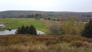
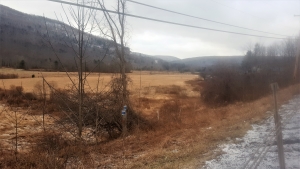
Winter is ending; it won’t be long before we are all outside again, enjoying our Catskills. Perhaps you will find yourselves at North Lake sometime this summer. Our absolutely favorite view, east of the Rockies, is from a location called Sunset Rock. It’s actually only one “Sunset Rock.” We really don’t know how many of them there are, but this is the one that overlooks North and South Lakes, along with the old Catskill Mountain House site. See our illustration (courtesy Wikimedia Commons).


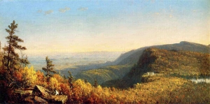
During the 19th Century Sunset Rock attracted almost all of those artists who belonged to the famed Hudson Valley School of landscape art. Many of them painted the vista that is seen there. Some very fine paintings date back to this time. You would think it to be hard for us to pick our favorite, but it is not. Ours was painted by Sanford Robinson Gifford in 1862. Gifford’s view looks to the south and includes the old hotel, at that time the most famed mountain resort in all of North America.

Like so many of his colleagues, Gifford cheated just a little bit. Why let reality get in the way of a fine painting? He created a broad landscape U, stretching out between his foreground and the hotel. We are glad he did that; that U suits our needs when we look at the painting. We saw it ourselves two years ago at Cedar Grove, the Thomas Cole Historical Site. It was quite the experience, you see, the two of us see this painted scene and the real landscape differently from most people. Whenever we look at this view, we are transported back into the Ice Age.

We stand atop the Sunset Rock ledge, always about 16,000 years ago. It is early in the history of one of the greatest chapters of the most recent Ice Age. This is called the Grand Gorge advance of the ice. We look left, to the east, and we see the Hudson Valley filling with ice. A great glacier has been descending this valley and it is on its way south toward the New York City vicinity.

We watch as the valley fills to the top. Then some of the ice passes through Gifford’s broad U. It continues westward. That ice is grinding into the bedrock below it and carving the basin that will eventually make North Lake. Next, we see another glacier rising from the vicinity of Kaaterskill Falls. It too carves the bedrock beneath it; that will become the basin of South Lake.

The two glaciers collide with each other, but the advance of the ice does not halt. We are still standing upon the Sunset Rock Ledge and we watch as the ice continues to rise before us. Far to the north, in what is today Labrador, it has been snowing heavily for centuries. Snow, up there, is piling up and hardening into ice. That ice has formed into an enormous ice sheet. A good bit of that ice has crossed the Adirondacks and then some of it has been funneled into the Hudson Valley. As the Hudson Valley ice has thickened, a lot of it has been flooding into the North Lake region and continuing onward. It will, eventually submerge much of the Catskills in ice.

That’s what we see at Sunset Rock; you will likely enjoy the view almost, but perhaps not quite as much.

The authors are just about ready to publish a new book “The Hudson River Schools of Art and Their Ice Age Origins.” Contact them at randjtitus@prodigy.net. Join their facebook page “The Catskill Geologist.”


A Catskills fossil Monster Feb. 1. 2024

in Uncategorized by

A Catskills fossil monster

The Catskill Geologists; The Mountain Eagle; April 2018

Robert and Johanna Titus


In our earlier lives, the two of us were very fond of Japanese sci-fi movie monsters. You probably remember Godzilla and Rodan, don’t you? And so it was a pleasant surprise for us to find out that the Catskills have their own monster. It’s not alive today; it dates back to the Devonian time period. Our Catskills monster has never been in a movie, not even a Japanese one. One of its cousins did achieve fame as the New York State fossil. It has, however, found a place for itself in the scientific literature. And it has received prominent placement in at least one museum. Scientifically, it is of some importance as a fossil.

Our ancient monster, in life, would have reminded you of a scorpion. That is, except for one thing; our monster was at least 40 inches long. Well, perhaps that does not make it a true monster, but it was a pretty big scorpion. The animal belongs to a group of invertebrate animals called the eurypterids. They are indeed distant cousins of scorpions. The common name for a eurypterid is the sea scorpion. That’s a bit of a misnomer as many, if not most of them, lived in freshwater habitats. Our Catskills monster has a proper scientific name; it is Hallipterus excelsior. 

    This monster was discovered in the western Catskills in the 1880’s. It was found in an old quarry in the village of Andes. The only part of it that was found was the head. But that alone, was ten inches long. The rest of the creature in our picture is a reconstruction by an artist named Nobu Tamura. That reconstruction is based on the study of a number of other, better-preserved eurypterids.

We can speculate that our monster lived in one of the many streams that crisscrossed the Devonian Catskill Delta, perhaps 385 million years ago. If you have been reading our columns then you know that the Catskill Mountains are a large petrified delta, comparable, in size, to the Ganges River Delta of Bangladesh. If you get out a good map of the Ganges Delta, you will find it has many fairly sizable rivers flowing across it. If we could drop living eurypterids into any of these rivers then they would quite possibly do well as invasive species.

Cousins of Hallipterus have long, well-developed claws. Those may well have been predators. Hallipterus, itself, does not have such claws. We can guess that it might have been a scavenger. Eurypterids are quite likely to have competed for dominance in their streams with our own ancestors – the fish. Fish lived in the rivers of the Catskill Delta too. Some of them would soon evolve into primitive amphibians, founders of a lineage that would eventually lead to the mammals – and us. Had evolution been a little kinder to the eurypterids, then it might have been their descendants that, today, would be reading the Mountain Eagle.

One of us, Robert, went to school with the Andes monster. That fossil was obtained by a Rutgers student, soon after its discovery. He gave the specimen to the museum at the Rutgers geology building. When Robert took introductory geology, the class was in the museum and he found himself seated next to the monster.

Contact the authors at randjtitus@prodigy.net. Join their facebook page “The Catskill Geologist.” Read their blog at “the catskillgeologist.com.”

A Meandering Stream 1-25-24

in Uncategorized by

A wandering stream in Winter

The Catskill Geologists; The Mountain Eagle; 4/6/18

Robert and Johanna Titus


   We frequently find ourselves driving up Rte. 145 on our way to Oneonta. We enter Rte. I-88 and head west. It does not take long before we have climbed a prominent hill and are heading downhill beyond it. We are always alert for signs of the Ice Age and we are very frequently rewarded. One thing we see on this part of Rte. I-88, is that the valley starts to display a flat bottom. Take a look at our photo.


That flat surface begins right below the highway and extends across the valley, all the way to the other side. If you have been reading our articles long enough, then you will (we hope) immediately recognize this feature as the bottom of an old glacial lake.
We are in the upper reaches of Schenevus Creek and that valley, during the closing phases of the Ice Age, had an active valley glacier within it. Glaciers of that sort typically find ways to dam such a valley and this particular dam must be located just a short distance west. We haven’t found it yet, but it must be what created the old lake. You might guess that this had been just a small pond, but you would probably be wrong. Where deposits of this sort are drilled, it is not unusual for those lake sediments to be hundreds of feet thick; the lake might well have been that deep.

It is not unusual for us to pull over, get out and just contemplate such a lake. We look down to its bottom and then across the valley to its other side. Its waters are dark with its great depths. Sometimes we see it covered in ice; sometimes the ice is only found along its shores. We would like to see it with mastodons walking along its shores, but we have not seen any of those elephants here – yet. Still, it is such an experience to travel back into time and see Schenevus Creek as it once was. It’s what we frequently call a privilege of being a geologist.

That’s the past but there is the present as well. Being lost is time does not allow you to ignore the present. We look again and we see, flowing back and forth across the old lake bottom, a modern stream. And it is not just any stream; it is a special type. This small creek, possibly the uppermost reach of Schenevus Creek, is something called a meandering stream.

Meandering streams are called meandering streams because meandering streams: meander. Take another look at our photo. In the foreground, the stream flows toward us, then it rounds a bend and flows away from us. Soon it bends again and – well— and so on. The stream wanders off into the distance, winding back and forth across the old lake bottom.

Meandering streams, like this one, are characteristic of flat landscapes and this lake bottom is the perfect flat landscape. Meandering streams are dynamic; over the courses of long lengths of time, they will erode the stream bank on the outside of each curve. Meanwhile they will deposit sediments on the inside of each curve.

Over long periods of time these wriggles will keep moving – much as when a snake moves along. If you could push a button and dash a century ahead in time, then this small creek, with all of its meanders, would be in a new and different location on the old lake bottom.

Contact the authors at randjtitus@prodigy.net. Join their facebook page “The Catskill Geologist.”

The Davenport Delta Jan. 18, 2024

in Uncategorized by

The Davenport Delta

The Catskill Geologists; The Mountain Eagle

Robert and Johanna Titus

Mar. 23, 2018


Did you ever take a good earth science course – in high school or college? Well, one of the things that commonly comes up is the structure of a delta. Deltas form when rivers or creeks flow into bodies of still water, oceans and lakes. The flowing water currents almost always carry a fair amount of sediment in them. That’s mostly sand, silt and clay. When those currents enter into a lake or ocean they generally slow down. Slow currents can’t carry as much sediment, so a lot of it gets deposited in the form of a delta.

Large rivers, flowing into oceans, tend to form large deltas. Think of the Mississippi Delta. Small creeks, flowing into your town’s skating pond, create small deltas. Big or little, deltas all have pretty much the same basic structure. The advancing front of the delta displays a steep slope that forms the delta’s outer edge. The sediments of this part of the delta display an inclined stratification. Those strata dip toward the lake bottom. The top of the delta receives sediments that are deposited on a flat plane. Those strata are horizontal.

Those inclined strata are called the foreset beds and, on top of them, are the horizontal strata of the topset. The adjacent lake bottom or sea floor, just beyond the foreset, receives a little more sediment, again deposited in flat stratified horizons. These are the bottomset deposits.

Well, in the end, a delta has a flat topset, a flat bottomset and a relatively steeply sloping foreset in between. Here’s the problem; deltas are underwater so we can’t see any of this. But, what if the lake drains, sometime after deposition of the delta? Then that delta would be left high and dry. We can read your minds right now: how can such a thing happen. Lakes don’t drain away, so the deltas will never be visible. Right?

Maybe – or maybe not.

Take a good look at our photo. It was taken just a short distance east of Davenport Center, looking north along Rte. 23. Close to the center of the photo is a house. Notice that behind it, to the left, is a flat surface. Just to its right is a relatively steep slope. At the bottom of that slope is another flat surface (almost hidden by trees). If you didn’t know better you might think that, arrayed right to left, was the bottomset, the foreset and the topset of a delta. But, of course, that can’t be, can it?

Well, if this is not a delta, then it is one remarkable imitation of one. We have a lot of explaining to do, don’t we? That supposed bottomset deposit, is a flat surface that extends quite some distance off to the east. We have done a little exploring there. Whenever we have climbed down to reach this “bottomset” we bring along a barbeque skewer. A what? Yes, a barbeque skewer; it is a very valuable piece of equipment when we are studying ice age deposits.

We drop down onto what we think is an ice age lake bottom and we try to drive the skewer into the ground. If it slides in easily then we know that there are no cobbles or pebbles in the ground. That is typical of lake bottom sediments. We try again with the skewer, and then again and again. If our skewer keeps sliding in, time after time, then we can assume that our flat surface is indeed the bottom of an ice age lake. That’s always a fun discovery. And, better still, this one was a lake with a delta.

Most of the Charlotte Creek Valley was dammed by melting glaciers at the end of the Ice Age. Lakes formed behind these ice dams and so it was that deltas, from time to time, formed in these lakes. We have discovered one of these old deltas. If you have a chance, go there and take a look; see the landscape there as we do.

Contact the authors at randjtitus@prodigy.net. Join their facebook page “The Catskill Geologist.”

A Milestone in Geology – Jan. 11, 2024

in Uncategorized by

A milestone in Geology

The Catskill Geologists

The Mountain Eagle; Mar 26, 2019

Robert and Johanna Titus


It probably won’t surprise you to hear that we spend a lot of time on the highways of the Catskills. After all, we have to get out there if we want to find things to write about. We are most fond of the region’s oldest roads. These were the old turnpikes. They were the earliest “superhighways” of the Catskills. There are two of them that still exist as modern public highways, and we find ourselves driving along them all the time. The most important one was the Susquehanna Turnpike which stretched out from Catskill all the way to Unadilla. We think that it connected with boats there. It’s often called the Catskill Turnpike; especially when you are going east. The other one was the Schoharie Turnpike which connected the port of Athens with the town of Schoharie. It likely continued off to the north. People traveled on both of these, but their main functions were the transport of goods. Farm produce would be brought east to the ports at Catskill and Athens. In return consumer goods would be transported west to the people who lived on the farms and villages out there.

Originally these were not public roads; they had been privately constructed and maintained. Tolls were, of course, charged. They were charged by the mile, so to help determine what was owed it was only natural to put up milestones along the way. And that is what gets us to the real topic of today’s column.

We are quite enthused about milestones. They are, after all, made out of . . . stone. And, as it happens, our home lies upon the Schoharie Turnpike. That helps us in our enthusiasm. Only something less than half of the old milestones can still be found, but there are still a number of them to be seen. When we spot one, we take note of our odometer and watch as another mile is ticked off. Sometimes that brings us to another milestone and sometimes not. We hope that you start to look for and take note of them. They are, after all, real history.

Recently, we noticed one on the old Schoharie Turnpike. It was on today’s Arnold Ave.  Head west from Greenville on Rte. 81. Turn right (north) onto Arnold and drive about a third of a mile and there it is, on the right. It’s almost hidden in the brush, but it is there. We got out and took a look. It was just what we expected, a fine piece of Catskill Bluestone. See our photo. Bluestone is good sturdy stuff; it has hardly weathered at all since it was installed. It’s a sandstone that formed on the floor of an ancient river. The carving on it was still clear; this one said “Catskill 24 miles.” It should have said something about Athens and that puzzled us. But it was about two centuries too late to ask anyone about that.

Are you interested? We recommend a book written by our old friend Dorothy Kubik and published by Purple Mountain Press. It’s called “The Story of the Susquehanna Turnpike” and it will fill you in on this important history of our region.

Contact the authors at randjtitus@prodigy.net. Join their facebook page “The Catskill Geologist.”

More About Bluestone Jan. 4, 2024

in Uncategorized by

More about bluestone

The Catskill Geologists; Mar. 8, 2019

Robert and Johanna Titus


Recognition, they say, is the first step towards learning–and liking something. Can you walk down the beach and put names on all the shells you see? Well, then your interest in mollusks will surely blossom into a love. It’s the same for trees, flowers and birds as you walk through the woods. And it’s very much the same with our science of geology. As you learn to identify fossils, minerals and rock types, you just naturally develop an affection for them. Soon you join a rock and mineral club and then it all gets better.


We play upon this in our columns; the more you learn to recognize geological features, the more fascination you will likely develop for them. Our job is only to introduce you to these features; you do the rest. In recent columns we have been walking down bluestone sidewalks and learning to recognize features upon them. They are widely seen throughout the Catskills and the two of us have become rather fond of them. We have walked down so many of them and learned to recognize the secrets that they can reveal to the trained geologist’s eye. Today, let’s introduce you to yet another.

Take a look at our photo; it shows a bluestone sidewalk slab displaying features called current lineations. They are also commonly known as parting lineations. We have also heard them called flow lineations. Whatever the name, these are very low ridges of sandstone, lying on the surfaces of bluestone slabs. They are composed of very thin horizons of sand, with the ridges often rising just a few grains above adjacent lower horizons.  Once you train your eyes to see these, you will find them to be common and easily spotted. But—what on earth are they?

Notice how strikingly parallel they are. They all pass left to right in our photo. That is a big clue. These are the products of river currents that long ago passed across the floor of, we guess, an ancient stream bottom. Geologists have calculated that these were strong currents, traveling at two to four feet per second. Some geologists even claim they can tell which way the current had been going. In our photo that might have been left-to-right or right-to-left. But we have never been able to convince ourselves that we can do that. Ours, here in the Catskills, formed on the bottoms of the Devonian age streams that flowed across the ancient Catskill Delta. That delta was a heap of sediment that formed at the bottom and west of the Acadian Mountains that once towered above today’s northern New England. The Catskill Delta hardened into what are called the Catskill Mountains. And, with that petrifaction witnessed many stream deposits turned into rock.

At the time of deposition these sedimentary structures would have been nearly invisible. It was only when the bluestone slabs were split by quarrymen that they sprang to life, becoming something the eye could take notice of. The process of splitting brought the lineations to light—quite literally.

So, now you have learned something you likely didn’t know before. Now, your walks down our bluestone sidewalks will take you into the Devonian and onto the floors of those ancient streams. Perhaps you should bring your children along—or, like us, bring your grandchildren.

Contact the authors at randjtitus@prodigy.net. Join their facebook page “The Catskill Geologist.”

Ripple Marks – 12-28-23

in Uncategorized by

Ripple marks

The Catskill Geologists

Robert and Johanna Titus


A few weeks ago, we ran a column about bluestone sidewalks. Those are sidewalks composed of Catskill sandstones, quarried, cut and split to make slabs that make very fine sidewalks — at least they used to. When cheap, good quality cement came along the bluestone industry  began a long slow decline. That’s too bad; bluestone is the stuff of good stories in geology.

We are going to talk some more about these things this week. We are going to talk about bluestone slabs and bluestone sidewalks – again. But this week, let’s pursue a different angle. There are bluestones and then there are bluestones. Some are just a lot more interesting than others; some tell some pretty interesting stories.

Take a look at our photo. It is a bluestone sidewalk slab from East Main Street in the village of Earlville, located a bit northwest of the Catskills and a bit southwest of Utica. This is not your typical bluestone slab; it is covered by some very striking features. They are called ripple marks. Ripple marks are identified when the surface of the bluestone is — well –rippled. Ripples are very low ridges on the surface of the rock. They are all parallel to each other. But there is more. Notice that the slopes of these “ridges” are asymmetric. The left sides display gentle slopes while the right sides are steep. Those are scientific clues, important clues about how they formed. That asymmetry tells us that the petrified sand which makes up the ripples, was deposited under the influence of currents.

These are called current ripples. They take us back to the Devonian time period, perhaps some 380 million years ago. Our region was, back then, part of something called the Catskill Delta. That was an enormous delta spread out below a great range of mountains that was located in what is today northern New England. Like any great delta, this one was crisscrossed by numerous streams, big and small. Each stream had currents, flowing downstream within them.

That gets us back to those ripples. The currents of those streams picked up sand and carried it downstream. Typically, much of that sand was moving across the stream bottom. It was also being sculpted by the currents into asymmetric ripples. The steep slopes faced downstream. In the case of our ripples from Earlville, downstream was to the right of the photo.

Now, don’t you see, our bluestone slab has become so much more interesting. It transports us to the bottom of a Devonian age stream, flowing across an ancient delta. The currents are not especially powerful, but they do move along at a clip strong enough to carry a lot of sand. Most bluestone slabs formed this way but, with this particular slab, the evidence is so much more convincing.

This slab was not alone; there were a number of them on that Earlville sidewalk. That allows us to read the mind of the man who built this. He must have had an inkling of what ripple marks were, and when he selected the slabs he wanted for his sidewalk, he had a strong preference for rippled ones. This is a work of art.

And that is how we would like you to start seeing these sidewalks. There aren’t all That many of them left. You should start becoming aware of them, especially the rippled ones.

Contact the authors at randjtitus@prodigy.net. Let them know where you have seen rippled sidewalks. Join their facebook page, “The Catskill Geologist.”


Floodplains? Part One

in Uncategorized by

Floodplains? Part One

The Catskill Geologists

Robert and Johanna Titus


We are guessing that you have a pretty good idea of what a floodplain is. That’s the flat surface which stretches from one side of the valley to the other. Right? Well, maybe, and then maybe not. These next two weeks we are going to visit a pair of “floodplains” and find out something very different. Let’s begin.

Our first so-called floodplain lies in the valley of the Batavia Kill, next to Rte. 23, just a little west of the town of Windham. Take a look at our photo taken along the highway. You see the very emblem of a floodplain, or so it would seem. This flat surface stretches down the valley almost to Prattsville. And, it is just as flat all the way. If you get a chance, take this drive and see what you think.

So, why is this not a floodplain? We weren’t fooled for even a minute. When we got a chance, we climbed down off the road with a barbeque skewer. That’s a bit of equipment we always carry in the back of the car. We use it when we see valley floors that look like this. We take the skewer out onto the supposed floodplain and drive it into the ground. If it goes in smoothly and all way, we try again, and then even one more time. With repeated successes we become confident that there are no cobbles or even bits of gravel in the ground. The eliminates the floodplain hypothesis. You see, the typical floodplain is composed of sediments carried along by a stream and then deposited during flood events. Fast flowing streams have no trouble carrying gravel and cobbles. Flood events have no trouble depositing them and making a new floodplain composed of course-grained sediment.

But what happened is that the barbeque skewers slid into the ground smoothly. There are no cobbles and no gravel to get in the way. What is there is a combination of sands and silts. Those are the deposits of lakes. Batavia Kill is a long and old lake bottom.  We find this all the time and all through the Catskills and Hudson Valley. That’s because there are likely to be lake deposits in all these vicinities. How come?

The answer is that these are glacial lakes that date back to the Ice Age. And, again, how come? We kept driving west along Rte. 23 and we approached the vicinity of Red Falls. Have you seen Red Falls? It’s a pretty cataract composed largely of red sandstones, lying a bit east of Prattsville. It’s worth the trip come warmer weather. Just east of those falls the valley is altogether different. There is nothing that even resembles a floodplain. Instead, great heaps of earth crowd the streambanks. This landscape is called a glacial moraine. That is something with its own story.

We have, once again, gone back to the Ice Age. We look east and we see that the Batavia Kill Valley is filled with ice. One glacier advances from the east while another approaches from the west. On the day that we make our time-travel visit, they are colliding. An enormous pile of earth lies compressed between the two. It’s a heap of earth called a glacial moraine. Our time travel continues, and we watch as the climate warms and the ice begins to melt. Soon a lot of it melts back and the glacier retreats toward Windham. Now that Red Falls moraine is left behind as an earthen dam. And behind that dam lies a growing lake. Let’s call it Glacial Lake Batavia.

Over time, the lake will accumulate a lot of sediment. When it drains that sediment will be left behind as a flat surface, that looks like a floodplain – but isn’t.  Let’s do something like this again next week.

Take this drive sometime soon and see how your understanding of the valley has changed.

Contact the authors at randjtitus@prodigy.net. Join their facebook page “The Catskill Geologist.”

Christmas Rocks Dec. 14, 2023

in Uncategorized by

Christmas rocks? in January?

The Catskill Geologists

Robert and Johanna Titus

Jan. 25, 2019


Have you joined our facebook page yet? We have been running it for several years now. It’s called, logically enough, “The Catskill Geologist.” We post notices of all our newest articles in it. Also, when Robert has a working memory, we post schedules of our upcoming speaking events, hikes and whatever else is keeping us busy. The page gives you a chance to be more engaged with what all we are up to. We have nearly three thousand members, so we hope you will join too. Soon.

All our members are able to actively participate in our facebook page and many do. We have had any number of people post pictures of geological phenomena that they have found. Often, they really do not know what it is that they are posting, but we can typically identify it or find someone who can. If all this sounds like something you would enjoy, then do join us.

Recently a member sent in a photo of a rock that he found in the upper Esopus Creek Valley. It was one of those catches-our-attention kinds of rocks. Take a look at his photo. You will quickly see what interested him. It’s a Christmas sort of rock, isn’t it? See the bright red color mixed with the green. Well, we recognized it right away. This sort of rock is referred to as being “mottled.” That’s a rock that displays a mixture of colors. They aren’t always reds and greens, but this one is so let’s talk about it.

But, first things first. We always like to say that the hardest thing to see in science is something that is not there. That’s the case here. This rock came from the Catskills, so it should be a stratified sedimentary rock; that is, it should be layered. But it is not stratified and that will turn out to be important.

The colors are the most important things. The red is typical of soils that form in tropical or subtropical settings. Have you ever heard of Georgia red clays? They are red soils found in Georgia. They formed during the last big interglacial time when the climate down there was a lot warmer and more humid than it is today. This sort of soil can be thus be called a tropical soil. Such soils today, commonly form within rain forests. There is always a lot of iron in any soil and the red color means that it is oxidized; it combined with oxygen. That occurs most often in the upper soil horizons where a good amount of air (with oxygen) is likely to be found.

So, what does the green mean? Green colors in this sort of soil occur farther down where it is likely to have been soaked in groundwater. That’s below the water table. Here there is much less oxygen for the iron to combine with and we say that the soil in not oxidized but reduced. Well our facebook member has found a rock that formed near the top of the water table where both oxidized and reduced soils can be found.

In either event we are looking at a soil forming processes, so this is a petrified soil, although not an especially good one. Soils are not typically stratified so that is consistent with what we have seen. It takes us back to the middle Devonian time period, about 380 million years ago, when the Catskills were not mountains, but a great tropical delta with red soils forming on it.

———————————————————————————————————————

   Contact the authors at randjtitus@prodigy.net. Read their blogs at “thecatskillgeologist.com” And please do join their facebook page “The Catskill Geologist.”

Big Yellow Taxi – 12-7-2023

in Uncategorized by

Bluestone sidewalks

The Catskill geologists; Jan. 2019

Robert and Johanna Titus


Do you remember the words from Joanie Mitchell’s old song “Big Yellow Taxi?” “You don’t know what you’ve got ‘til it’s gone.” We certainly learned that when Hurricane Irene destroyed the old covered bridge at Blenheim. It was one of the last few such bridges in our region. Once there were many of them, but now they are all nearly gone. Long ago, people would have just taken each of them for granted. Then they were, one after another, taken down and replaced by far more modern bridges. That was chalked up to “progress.” Then they were nearly gone, and we came to know what we had, but only after it was nearly gone.

How many times have you seen “We buy old barns” signs along the highways? Old barns can be torn down and their wood commands a premium price. Do you take much notice when you pass an old barn? Perhaps you won’t notice any of them until they are nearly gone. We fear that may well happen. It’s a sad thought.

Why are we talking about these things in what is supposed to be a geology column? Well, for a very good reason. Our region was once densely dotted with bluestone sidewalks. There had been a very large bluestone industry throughout the Catskills and much of that industry was devoted to making stone slabs for those sidewalks.

We have written about bluestone a number of times in this column. It’s a form of sandstone that was deposited in river channels that crisscrossed the Devonian aged Catskill Delta that once covered the Catskills region. That was back about 375 million years ago. Bluestone made a very good sidewalk material; it was tough stuff and held up very well under long periods of heavy use. It did not get slippery when wet, so people didn’t much have to worry about falling. And it was good looking, adding to our region’s rustic beauty. But then bluestone sidewalks began to disappear. And then a lot of them followed.

Good quality cements came along, and they could be turned onto fine sidewalk slabs. When an old bluestone sidewalk wore out, it was only sensible to replace it with cement. Progress had struck again. These modern cement sidewalks work just fine, and they are less expensive. But they just aren’t the same. Walk a cement sidewalk and see if you can feel the absence that the two of us feel. There is little beauty in cement, there is none of bluestone’s rusticity and nothing that can be called heritage. There is just a palpable absence in cement. And the more you think about it, the more you notice it.

Don’t get us wrong; we are realists. We know the era of bluestone is over. It will not likely return. Our efforts here are simply to call your attention to these old sidewalks. You cannot likely pass a covered bridge without noticing it, but it is easy to miss a bluestone sidewalk. We would like it if you looked around and watched for bluestone in your neck of the woods. We are fortunate to have a good one in our hometown of Freehold. See our photo. Perhaps you can find one near your home. We hope so; let us know if you do.

Contact the authors at randjtitus@prodigy.net. Join their facebook page “The Catskill Geologist.” Read their blogs at “thecatskillgeologist.com.”


Go to Top