"I will never kick a rock"

Catskill furniture Feb. 18, 2021

in Uncategorized by

On the Rocks – Literally!

On the Rocks – The Woodstock Times

June 22, 1999

Updated by Robert and Johanna Titus


Rustic Adirondack furniture has been popular for generations. People find austere looking bent trees and fashion all sorts of pieces from it. The style is perfect for the interiors of mountain cabins and for exteriors anywhere. You don’t actually have to be in the Adirondacks, the style can be seen all over the east, including the Catskills.

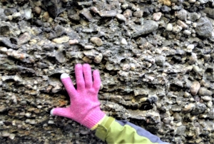
You will see Adirondack furniture hereabouts, called that even though it’s made from local wood. But there is also something that, we think, should be called “Catskill furniture.” You won’t see it inside or even outside of homes, however. You will have to go hiking if you want to see it at all. It’s made from local materials but not wood. Catskill furniture is made of bluestone and can only be seen in old quarries.

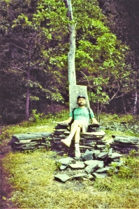
All the old bluestone quarries have enormous piles of waste rock. These are the irregular slabs of sandstone that were not suitable for sidewalks or any other use. Quarrymen just left them in heaps. Hikers, apparently, have not been able to resist taking these slabs and piling them up into “furniture.” If you spend much time on the mountain trails you will see many of these bits of folk art. The most popular are the thrones, great seats of stone. Sometimes there are just single thrones, perhaps for a bachelor king. Then there are paired seats and even thrones for three.

But there are more than just thrones for the mountain kings. There are tables and obelisk-like columns. There are walled rooms and, sometimes when there is water in the quarry, spring houses. We have seen whole complexes of rooms with tables and chairs and all manner of comforts. Naturally one gets hungry building all that furniture and of course there are barbecues. We expect that hikers camp out in these complexes and have made them quite comfortable. All this reminds us of some of the complex cliff dweller Indian sites of the American southwest.

One question we have is “how old are they?” It’s not obvious from just looking at them. After all a throne of stone could have been stacked up last week or a century ago, how can you tell? The stone doesn’t develop the patina of age that we see in wood. But, we are guessing that few of them are all that antique. We have not seen much in the way of lichen growth on these stones. If a rock is left exposed for a long enough period of time it will develop an encrustation of lichens. The longer it lays there, the better the growth. Our stone villages apparently have not been there long enough to grow many lichens.

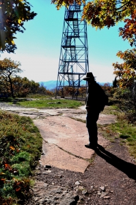
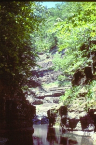
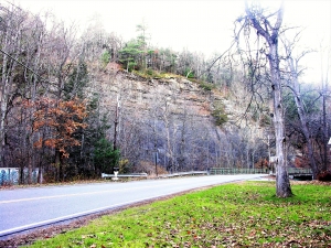
Where can you go and see some of these? The Overlook Mountain trail will take you north to Plattekill Mountain where there are quite a few old bluestone quarries. You can explore these and find a number of the neo-neolithic sites. The very best we have seen so far are on the lower slopes of Sugarloaf Mountain. Take the blue trail toward Pecoy Notch and you will pass through a heavily quarried section. There we saw some very fine Catskill furniture, including what amounted to a small village.

There are some obvious problems with Catskill furniture. None of it is very comfortable. It’s hard to rearrange the furniture and impossible to order some for delivery. But so what; all of this is just for fun. It’s a rough sort of folk art, but it does reflect a basic human characteristic. We all seem to like to leave monuments behind, be we ancient Druids or modern Catskill hikers. So, hail to the mountain kings, and enjoy a fine hike in the Catskills.

Contact the authors at randjitus@prodigy.net. Join their facebook page “The Catskill Geologist.”

Beautiful brachiopods Feb. 11, 2021

in Uncategorized by

Coming out of a shell

On the Rocks – The Woodstock Times

Nov. 19, 1999

Updated by Robert and Johanna Titus


Beauty is in the eye of the beholder and who can exactly define such a thing as that? Do female porcupines look beautiful to males? The same for female Aardvarks or Armadillos. We hope so, but none of them look beautiful to us. Even if it should be wholly subjective matter, we think that there just are some creatures that are beautiful while others are ugly. The swan would be on most people’s list of beautiful. So too the thoroughbred horse. We think that most people would regard the Walrus as ugly. There’s no offence intended here, after all, animals cannot be offended, or complimented for that matter; they don’t care. In the struggle for existence, it doesn’t often matter how pretty a creature is. And, in Nature, the struggle for existence is what counts.

Nevertheless, we would like to talk of beauty in the animal kingdom today. And we are not thinking of soft furry animals. The invertebrates include more than their share of ugly animals, creepy crawlers that repel us. But there is also beauty among these cold-blooded, dim-witted creatures, and that can be the case even hundreds of millions of years after death.

We are thinking about a fossil shellfish named Mucrospirifer, a member of a group called the brachiopods. A brachiopod, like a clam, has two shells, or valves. But brachiopods are not clams; their anatomy does not even place them among the mollusks. Their shells are entirely different. Among the clams, symmetry planes pass between the valves, in the brachiopods, symmetry is down the middle of each one. In lifestyles however, the clams and brachiopods do have much in common. Both lie on the sea floor and draw sea water into their interiors. Both filter the water and find microscopic bits and pieces of food in it. But both have complex and differing filtering mechanisms. All this is important, it tells us that the two groups evolved separately.

Having different evolutionary histories, it is not odd how different their geological histories have been. Brachiopods were among the dominant seafloor dwellers up until the end of the Permian time period, about a quarter of a billion years ago. They nearly disappeared in the great worldwide extinction that occurred at the end of the Permian. Clams had been around as long as the brachiopods, but they have flourished since that awful extinction. The brachiopods have survived but are just barely limping along.

The brachiopods were at their peak during the middle Devonian when Woodstock was at the bottom of something called the Hamilton Sea. And Mucrospirifer was one of the most abundant inhabitants of Woodstock at that time. Mucrospirifer is a genus name and there were many species within this genus. All are attractive but some were of a truly beautiful form. The ones we are illustrating are among our personnel favorites. They have long delicate and graceful left and right points and fine sculpturing. This morphology adapted them for life on a quiet and muddy-bottomed sea floor. Their lives were simple; they just opened their valves when they were hungry and filtered sea water. When not hungry, or if they were disturbed, they would close their shells and remain protected within them. Not very exciting but that doesn’t matter. Believe us, brachiopods are never bored. we doubt that they even know that they are alive.

Mucrospirifer was a big success during the Devonian and for that long time it flourished in abundance. Eventually its success faded and it numbers diminished. Sometime and somewhere, there was a last Mucrospirifer. We don’t know where or when. When it died the group was extinct. It’s sad, but that is the fate of all species including, someday, our own.

But even in extinction, they are still beautiful creatures, and they deserve to be remembered. We always enjoy finding a good specimen. You can look for them in some of the fine-grained sandstones and shales of the Hudson Valley. Try the strata along John Carle Road which is off of the eastern end of the Glasco Pike. Better still, journey up to the Greenville vicinity. The stone walls west of that town yield many of them. If you do go hunting, please limit yourself to just one good specimen and leave the rest for others to see. After all, the form has already gone extinct once.

Contact the authors at randjtitus@prodigy.net. Join their facebook page “The Catskill Geologist.”

The Hudson River School of Rocks. Feb. 4, 2021

in Uncategorized by

The Hudson River School of Rocks

On the Rocks – The Woodstock Times

Dec. 2, 1999

Updated by Robert and Johanna Titus


Some years ago, Robert attended the national meeting of the Geological Society of America and was surprised to see an agenda with three papers that were devoted to the Hudson River School of Art. Getting papers accepted at the national meeting is a very competitive process so he was surprised that the meeting’s organizers would devote so much time to art. What did not surprise him was that it was this particular sort of art. But we bet that this is a bit of a surprise in an artistic community such as Woodstock so let us try to explain.

Thomas Cole, one of the founders of the Hudson Valley School, got his start here in the Catskills. It was 1825 and he was probably the first painter to get up to the newly opened Catskill Mountain House Hotel. Before him, up there, lay nearly all of the Hudson Valley and behind him were all of the Catskills. It was the Catskill landscape that attracted him the most. This great landscape was still largely wilderness and the young artist would be the first to explore its scenic opportunities.

Our mountains would bring Cole quick success, but he did have one problem: back then the great traditions of landscape art came from Europe, and it was the custom of European artists to use the ruins of Classical cultures as emblems of antiquity. They liked to stick in the remnants of a Roman temple or two in order to communicate that their landscapes were truly old. Obviously, Cole could not do this, after all very few Romans ever got to North America during Classical times.

Then again, and this is where we geologists come in, Cole was working at a time when geologists were revolutionizing the very concept of time itself. In 18th or early 19th Century Europe, a Classical ruin was seen as dating back to near the beginning of time, especially if you accepted a biblical age of 6,000 years for the age of the Earth. But by the 1820’s geologists had come to understand that the Earth was probably many millions of years old and, indeed, very likely much more than that (billions, in fact). A two-thousand-year-old ruin didn’t look very old given the new framework of time!

Without ancient monuments, Cole struggled to find native emblems of antiquity. He tried the figure of an Indian in his famous painting of Kaaterskill Falls, and that sort of worked. Cole used the tangled chaos of the American wilderness as another approach. Our wilds had a venerable, tangled and mossy look to them when compared to the tamed, park-like landscapes of Europe. But it wasn’t until the 1830’s that Cole found another solution: the very rocks themselves.

It’s in his “Course of Empire” that we find Cole using this solution. Course of Empire is his famous series of five landscapes each showing a stage in the history of a mythological Classical empire. The first painting showed that culture’s roots in a primitive tribal culture. Later (second painting), it passed into a stone-monolith- building second stage, and from there blossomed into a Rome-like empire (third painting). Sadly, Cole’s Empire disintegrated in war (fourth painting) and fell into ruin in the last scene. Throughout the five canvases a great somber mountaintop of rock loomed above the community. And throughout the long history that mountaintop never changed one bit, it was permanent while all below eventually disintegrated. In this way Cole turned the tables on European painters: Classical cultures were recent and ephemeral while the rocks beneath were the true emblems of time.

That was a pretty heady theme in the 1830’s and 40’s, when Cole was most active. And that same heady theme was central to the geological community of the very same age. We geologists were looking at rocks exactly the same way as Cole and his colleagues; for a moment of time Art and Geology explored the same literal and intellectual landscapes.

Art is ever-changing, and of course, it has moved on. But the notion of great antiquity remains fundamental to geology and geologists integrate it into all of our thinking. Thus, it really is no surprise at all that we geologists still venerate the great Hudson Valley School of Art. Those paintings speak to us in a very personal way.

Contact the authors at randjtitus@prodigy.net. Join their facebook page “The Catskill Geologist.”

Fire and Ice at Overlook Mountain 1-28-21

in Uncategorized by

Fire and Ice at Overlook

On the Rocks/Robert Titus

The Woodstock Times

Oct. 14, 1999


The fire tower atop Overlook Mountain is now open to the public, and this is the first autumn that you can legally and safely climb to its top. Sadly, we know that many of you have never even been to the top of Overlook, let alone enjoyed the view from the top of the tower. It’s about time.

The climb to the top is a moderately long one, but it is not all that difficult. There are no cliffs to climb, just a long steady incline. Even if you are not in good shape, you can make the ascent. You will know you have almost gotten there when you see the ruins of the old Overlook Hotel. They’re worth the trip by themselves. Past the hotel, bear right and walk along the edge of the escarpment, the view is grand. Farther along, you reach a substantial topographic shelf right on the mountain edge. This location is favored by campers and is especially busy on nights of the full moon.

Eventually you will want to complete the ascent and go to the fire tower. The tower sits upon a bare, windblown knob of bedrock. The tan sandstones have a venerable history. They were the deposits of the Catskill Delta. We are not entirely sure of the exact origin of these rocks, but many geologists argue that they were the sediments of meandering streams, flowing across the old Catskill Delta. That’s what may have been here. Or maybe not; one is never sure with rocks that are nearly 400 million years old. They are not my real story today, anyway.

The story that we are sure of is about the glaciers that were once here. Right on the trail, just as you make your absolutely final approach to the fire tower, is a very fine example of a glacially polished bedrock surface. The passing ice sanded the rock into its smooth form. Upon that surface are some very fine examples of glacial striations. Striations are long straight scratches that were gouged into the rock as passing glaciers dragged rocks and boulders across the bedrock. Along with the striations are some chatter marks. These crescent-shaped gouges are the products of boulders that sort of skipped across the bedrock as they were being shoved by the moving ice. It must have taken the pressure of a very thick glacier to perform all this damage. A very thick glacier indeed, and that’s where the story gets interesting.

The Overlook striations have a compass direction of south 30 degrees west. We are very familiar with that orientation. We find it at the top of many of the Catskill peaks. This marks the path of the great Wisconsin ice sheet as it passed across the Catskills and advanced toward Long Island, New Jersey and Pennsylvania. This was an enormous sheet of ice, comparable and maybe bigger than the ice sheet of Antarctica itself. If you climb the fire tower, spend a moment contemplating what was once here. The entire landscape all around you was submerged in ice. It is an incredible image, one we never can quite fathom ourselves, even after decades of studying such things.

Just how deep was the ice? Remember those striations, it took the weight of a lot of ice to make them. How thick was it? Well, late at night in geology bars, we argue and debate such things, but we never do come to any final conclusions. Many geologists believe that all of the Catskills were under the ice, others argue that the highest peaks escaped the reach of the glaciers. One thing is for certain however, at least a thousand feet of ice lay above the top of the Overlook fire tower. Look around at the adjacent peaks and then gaze upwards those thousand feet or so and think about all that for a moment. Up there, there once was a great arctic plain, a vast, flat, white waste. Temperatures must have averaged many degrees below zero and winds must have blown snow about constantly. Next, look down to the floor of the Hudson Valley nearly 3,000 feet below. Fill in all this space with ice and then extend it south to Long Island and north to beyond the pole. If you can imagine such a thing, then you are beginning to appreciate just what an event the great ice age was. And it may have happened more than once. We found a second set of striations at a compass direction of west 20 south. It seems glaciers overtopped Overlook at least two times.

Today you would have to go to the south pole to encounter such a landscape. But, if you make yourself a geologist, even just for a day, you can travel to such a landscape today. It’s up there at the top of Overlook and they throw in a fine autumn landscape for free. Many people worked long and hard to open up that tower, go and enjoy it.

Contact the authors at randjtitus@prodigy.net. Join their facebook page “The Catskill Geologist.”

A Grotto in Kaaterskill Clove 1-21-21

in Uncategorized by

A Reckless Youth Spent at the Artist’s Grotto

On the Rocks – The Woodstock Times

Aug. 26, 1999

Updated by Robert and Johanna Titus


Late summer is a hard and stressful time of the year for many of the plants and animals out there. That’s the time when the streams run dry. It’s hot in August and the evaporation rate is high, but also the trees are thirsty, and they have been drawing a very large amount of water out of the ground. The results are predictable, first the soils dry up and then the streams follow. We understand the hardships that a lack of water places on the ecosystems around us, but that’s Nature’s way and Nature is cruel. Fortunately, all creatures have evolved in this setting and they are adapted to all this; they will suffer but they will survive.

It is, however, not such a bad time to be a geologist. We are able to go and see many things that are normally under water. It’s easy, for example, for us to hop around on the dry boulders and work our way up a stream. The channel deposits and the bedrock along the banks of the streams are all well exposed, and that is a real treat for a geologist, and we always try to take advantage of it.

Lot’s of other people too. You will currently see large weekend crowds in some of the bigger Catskill creeks. The people are taking advantage of the remaining swimming holes and they are also simply enjoying the easy hiking. And so it is that this is a very good time of the year to go and visit the lower stretches of Kaaterskill Clove, a location called “Artists Grotto.” We are talking about that part of the stream that lies just between the two Rte. 23A bridges that cross the river just above Palenville and just below Fawn’s Leap. Kaaterskill Clove is a spectacular canyon cut into the Catskill Front, but this part is in many ways the best. The river has literally sliced into the mountains here and cut a deep slash, a canyon within a canyon, and it is so nice to visit now.

The geological story of this canyon started right after the last glaciation. Back then a great heap of sediment was carried out of the mountains and dumped in this lower stretch of the clove. If you look at that bit of canyon just downstream from the upper bridge, you will see what is left of that sediment. It’s a heap of course grained, very red sediment. There are lots of boulders, cobbles, and gravel mixed in with plenty of red sand. After this material had been deposited, Kaaterskill Creek went to work eroding it away. The river sliced quickly and easily into this soft stuff and began the carving of our pretty little canyon. As the river cut through this sediment, it found that the bedrock beneath was not much harder. These are mostly soft red shales, and they don’t put up much of a fight against any erosive river.

That’s what made the best of our little ravine. The shale is just hard enough to create perfectly vertical cliffs as the river cuts through it. But it is also soft enough to allow for a rapid down cutting erosion. That’s why this part of the canyon is very narrow and very vertical. There are also a few thick sandstones along this stretch, and they affect the landscape very differently. Sandstone is sturdy stuff, and it holds up well against the erosion of the stream waters. The sandstones form big and little waterfalls. Typically, there are good swimming holes associated with the sandstones and so people love these sites. They swim in the pools and then climb on the rocks to bask in the sun.

All this is typical of a stream which has not been around all that long a time and that is the case with Kaaterskill Creek. It’s sometimes referred to as a “youthful stream.” It began to carve its way into the mountain only during the ice age and that is not very long ago maybe only 120,000 years old or so. That makes it a baby among rivers. The Hudson, for example, goes back many tens of millions of years. Unlike Kaaterskill Creek, the old Hudson has outgrown its wild youth. You will find no deep, vertical canyons in the Hudson. There are no waterfalls or even rapids along the older river, it is too mature for such feckless activities.

The two streams provide us with different sorts of natural beauties: Kaaterskill Creek provides us with a special wild and powerful sort of nature, one which the old Hudson River School artists called “sublime.” The Hudson gives a quiet and serene landscape, the old artists might have called it “picturesque.”

Either way, the artists won.

Contact the authors at randjtitus@prodigy.net. Join their facebook page “The Catskill Geologist.”

Regression to a Mean 1-14-21

in Uncategorized by

Regression to the Mean

On the Rocks –

The Woodstock Times, June 17, 1999

Updated by Robert and Johanna Titus 


We live in a world where we are used to the idea of rising sea levels. During hurricane seasons, we expect to see the rising of the ocean’s waters and the flooding of coastal landscapes. We may not be comfortable with the idea of coastal erosion, but we do see it as the “norm.”

Few of us would recognize it, but this is a bias. We are comfortable with the notion of rising sea levels not because that actually is the norm but because we live in a world where the climate has been warming up ever since the end of the ice age. As the climate has warmed glaciers have melted, and meltwater has poured into the seas raising their levels worldwide.

There is, however, nothing actually inevitable about rising sea levels; it could be the other way around. Suppose that the climate was cooling down. Then ice would be forming, water would be withdrawn from the sea to make the ice and the sea levels of the world would be dropping. Throughout the length of Earth history, it must be that there have been as many times of dropping sea level as there were risings. Neither is favored over the long term.

A rising sea level is often called a transgression while a falling sea level is called a regression. Transgressing seas do leave coastal regions susceptible to storm flooding and damage. Such coasts are prone to erosion and, in fact, do erode away.

Regressive coasts are quite different; as the sea levels drop rivers bring sand and mud into the seas and pile them up. The coasts advance seaward. We call that progradation.

You and I are not likely to ever see a good regression, not unless there is a dramatic shift in the climate. So, we will never see a whole coastline prograding. But we can go back in time to eras when the seas were retreating and see the results in the rocks. From Woodstock, travel east on the Glasco Pike to Mt. Marion. There, where Plattekill Creek crosses the road, you will see a towering outcrop. It is mostly black shale. The rock was once black mud deposited in relatively deep waters of the Devonian seas, a little less than 400 million years ago.

The black shale is a fine-grained deposit of mud. Mud accumulates in very thin sheets at the bottom of a quiet sea. The sea was quiet because of the great depths. There were no currents, or tides or waves in the deep water. But look upwards; at the top of the exposure, you will see a number of thick-bedded strata. If you could get up there you would find that these are sandstones. Overall, the outcrop grades from shale to sandstone, from mud to sand. That’s the regressive sequence.

What was happening? At this time the Acadian Mountains, located where the Berkshires are today, were actively rising in a dramatic and important mountain building event called the Acadian Orogeny. As these mountains uplifted, they began to weather and erode. Large masses of rock were converted into even larger volumes of mud, sand and gravel. That’s the fate of weathering rock. Mountain streams transported all of this material as sediment into the adjacent sea. That’s us right here, Woodstock and the whole Hudson Valley region were under water. Marine currents sorted out all of the fine-grained muds and carried them far out to sea where they settled to the bottom as the black muds that hardened into our black shales.

But as mountain building continued gluts of coarse-grained sediment overwhelmed the muds and layers of sand began to pile up Thus, when this sediment hardened, we ended up with the shale to sandstone sequence. That’s a regression.

Go back westward on the Glasco Pike. You will soon encounter other outcrops. These are mostly more sandstones. At the top of the hill, you will even see the cross section of an old river channel. The regression had succeeded, it had transformed a sea into a land area. There should be one of those New York State historical markers up there. It should say “Here the Woodstock area rose out of the sea.” After all, that was an historical event.

Contact the authors at randjtitus@prodigy.net. Join their facebook page “The Catskill Geologist.”

Glaciers of Echo Lake

in Uncategorized by

A visit to Echo Lake

On the Rocks – The Woodstock Times

June 10, 1999

Updated by Robert and Johanna Titus


The Catskills are rightfully known for their wonderful scenery. Our mountains abound in hidden green cloves with brown and red ledges towering above. Our hiking trails bring us into these secluded natural settings. They have an air of primeval mystery and our park system keeps them that way. Elsewhere around the globe, there are many very different types of mountain landscapes. About as different as you can get are the Alps: there is nothing hidden or secluded about those great peaks. They stand right in the center of Europe with their white mountaintops soaring above the surrounding lands with an in-your-face dominance of the horizons. No one would ever get the Alps mixed up with the Catskills; no one, that is, except a geologist.

Our image of the Catskills of 14,000 years ago has a great deal in common with what we see in the Alps of today. The emblem of today’s Swiss landscape is the Alpine glacier, often called a niche glacier or commonly as a cirque glacier. These form in bowl-shaped mountain depressions, called niches, where snow accumulates, piling up to great depths and hardening into the ice that then begins its flow downhill as a frozen stream. During times of cold climate Alpine glaciers advance into the valleys below; during warmer times they melt back and sometimes even disappear. Not surprisingly, they are very erosive phenomena and have done a lot to shape the Swiss terrains. In fact, we have a word for these special landscapes; we call them “Alpine” landscapes. Similarly, the local glaciers of our ice age did a great deal to form the Catskills as we know them today. If you want to truly understand your Catskill landscapes, you must know something of the Alps!

And that includes, right here in the Woodstock vicinity. Take the red trail almost to the top of Overlook Mountain and then turn north on the blue trail. In about another mile take the yellow trail off to the west. You will soon find yourself descending into one of those mysterious hidden Catskill cloves. At the bottom is a beautiful little pond called Echo Lake. That’s not one of those silly romantic sounding names picked by a housing developer, the lake is very aptly named. Clap your hands or shout abruptly and you will find out why.


Look around you and you will see that Echo Lake is nestled at the bottom of a grand natural amphitheater. Steep slopes rise above on three sides. The only gap is to the southwest, there the lake waters make their escape and flow into the upper Saw Kill. This type of amphitheater is known to geologists as an Alpine niche, a place where once a glacier got organized. We also call such a feature a cirque and it was within the Echo Lake cirque that the Saw Kill glacier accumulated and then began its slow downhill flow. Beyond Echo Lake the Saw Kill glacier flowed at least as far as Cooper Lake and probably much farther.

Cirques are common Alpine landscape features. The steep walls behind the ice are called the headwalls; They were eroded by the ice that was once present. As the ice began its downhill motion, it plucked blocks of rock loose and thus shaped the steep walls. Similarly, the passing ice scoured out the basins of the lakes; in Switzerland such basins are called tarn lakes. Echo Lake is perfectly typical of an Alpine cirque and that is what makes it such a remarkably attractive Alpine landscape feature.

Cirques are common phenomena throughout the Catskills, but we don’t know of any others as well developed as this one. How many others are here and where are they located? That has been a heatedly debated issue ever since the early part of the 20th Century when they were first recognized. Some geologists have argued that there are very many of them, perhaps scores. Others have argued that there are only a handful and that all the other supposed cirques are nothing more that stream erosion in the upper reaches of our mountains. We think that the Echo Lake cirque is a safe bet. It’s at the top of the Saw Kill glacier which is one of the best known and most widely recognized Alpine glaciers of the Catskills.

It’s a wonderful time of the year to visit Echo Lake, and when you go there please do enjoy our summer scenery. But also pause for a moment and try to imagine the snowy high peaks of Switzerland, for that is exactly what you are seeing here.

   Contact the authors at randjtitus@prodigy.net. Join their facebook page “The Catskill Geologist.”

Puddingstone at North Lake 12-31-20

in Uncategorized by

Rock Pudding

On the Rocks – The Woodstock Timed

Aug 12, 1999

Updated by Robert and Johanna Titus 


As geologists we are, of course, very fond of rocks. We find the study of bedrock always interesting, often fascinating and occasionally even engrossing. But there are limits; they are, after all, just rocks, and rock is pretty commonplace stuff. But, occasionally, you will round a bend in the trail and be startled by some remarkable bedrock exposure. There are a couple of these on either side of Kaaterskill Clove. When we visit with groups of people, there is almost always someone who cries “whoa” in complete surprise. This remarkable rock is locally called puddingstone.

Go to North Lake State Park and take the blue trail north. That’s the escarpment trail and it is always worth the hike. As you head up the trail you will pass over the ledge at Artist Rock and then cut uphill and away from the escarpment for a bit. Eventually, you will pass left of, and then under a knob of rock called Sunset Rock. It is right there that you first encounter the puddingstone. The puddingstone ledge is up to 20 feet thick. It rises vertically above the trail, so it is quite imposing. But it is the composition of the rock that generates the excitement.

Puddingstone is known, formally, to geologists as conglomerate. That’s a rock composed almost entirely of pebbles. The pebbles are all cemented together, and the effect is to produce a visually stunning lithology. In this case there are a great number of cobbles mixed in with the pebbles so that enhances the visual impact.

But what exactly is a conglomerate? That is, how did this peculiar rock come into existence? The answer to those questions comes slowly with a close examination of the rock. First, notice that most all of these pebbles are nicely rounded. We say that they have been stream washed and rounded by abrasion during a time when they were carried down a river. But where did the stream come from?


Look carefully at the pebbles and cobbles and you will find that they are of all sorts of different types. The largest number are white pebbles of quartz. As you look carefully, you will find a number of other lithologies. Let’s skip a detailed analysis, but it is safe to say that the pebbles are heterogeneous, and they must have come from a place where the bedrock was equally heterogeneous. That was an old mountain range.

The unit of rock is called the Twilight Park Conglomerate. It’s named for a community, across Kaaterskill Clove, where some more nice exposures can be seen. The Twilight Park Conglomerate is part of the Catskill sequence. That’s sediment which washed out of the ancient Acadian Mountains during the Devonian time period. To the east those mountains once towered, perhaps as high as the Andes of today. Like all mountains, they suffered from weathering and erosion and slowly crumbled. During their destruction there were times when unusually large amounts of very coarse-grained material washed out of the mountains, traveling down steep mountain streams, and washing out onto the flat lands below. That’s what happened here.

Look east from Sunset Rock. Imagine blue and purple mountains rising before you. They are white at their peaks. Enormous heaps of brick red coarse sediment lap up onto the flanks of those mountains. Great pounding, roaring, white water mountain streams are cascading out of the mountains and their raging flows continue across those red sediments. The streams flow out onto a large flat delta plain and they slow down as they lose their slopes. It’s then that they lose their ability to transport gravel and they deposit the thick layers of pebbles. These streams wash back and forth and spread the gravel out in thick deposits. Tens of millions of years pass by and the gravels are slowly buried by a thick sequence of more sediment, mostly sand. It all gradually hardens into today’s Catskill sequence.

Those old mountains eroded away entirely, hundreds of millions of years ago. These puddingstones and their pebbles are part of what is left. That, we think, is fascinating.

Contact the authors at randjtitus@prodigy.net Join their facebook page “The Catskill Geologist.

Monsters in the Closet Dec. 24, 2020

in Uncategorized by

Monsters in the Closet

Stories in Stone -The Columbia County Independent

Feb. 2004

Updated by Robert and Johanna Titus


We don’t know what it is about this time of the year, but we seem to start finding silverfish around the house, especially in our closets. What attracts them? We don’t know; they are just bugs, who can explain them.

Well, in fact, they are not just bugs. If you have a problem with silverfish do what we did. Stop for a moment and take a good look at them. They are, in fact, something quite special. If you can, get one to slow down long enough to look at carefully, you will see something very interesting. That’s a tough thing to do as they love to scurry around very quickly and don’t like to stop to be looked at. We recommend some bug spray, after all, it is the interest of science (and a bug-free home). Anyway, once you get one to stop moving you will quickly see that they are not like other insects. They do have six legs as all good insects should, but that is about it. Silverfish do not have wings and most insects do have wings. That’s a very primitive trait among insects.

Once you get one to stop moving you can see what they look like. They might remind you of little scorpions, but that is superficial. They have a series of silver-colored scales running the length of their backs, hence the name silverfish. There are two bristly antennae up front and what looks like three more behind. That’s why they are sometimes called bristletails. They do have six legs as do all proper insects., but that’s about it. All in all, you don’t have to know much invertebrate zoology to tell that silverfish are very primitive insects, they just look it, and that’s why they are so special.

You see, silverfish belong to a very ancient and primitive group of insects. Most insects have wings, four of them in fact, but the silverfish have none at all. Nor do any of their ancestors; the lineage extends back to before insects evolved wings. And when we say extends back, we mean a long, long time. Silverfish date back to the Devonian time period. Around here that’s important as all of our local bedrock is Devonian in age. As luck would have it, most of our sedimentary rocks were deposited in a terrestrial setting, one where insects abounded. This was the Gilboa Forest of the Catskill Delta complex.

The land of Gilboa was, like any great delta, a morass of forests, lakes, ponds, swamps and rivers. It was tropical in climate and it must have been a lush environment, perfect for insects. And it is rich in fossils, including insects, not terribly different from silverfish.

Creatures like silverfish have a special place in the hearts of paleontologists. We call them “living fossils” and that’s a good term. They have evolved so slowly and so very little that they remain virtually unchanged from their ancient ancestors of nearly 400 million years ago.

Living fossils are like keyholes into the past. We can look at them and see creatures as existed in the ancient past. In this case silverfish speak to us of the early ancestry of insects. These are the insects that first lived on the lands of the distant past, long before they evolved an ability to fly, chirp, sting, ruin picnics, and all the other things that modern insects do. We paleontologists love to see living fossils; they give us a firsthand look at the past.

Some people are proud to be able to trace their ancestry back to the Mayflower. That gives their families a 400-year history in America. We guess that is nothing to sneer at, but silverfish can trace their American ancestry back 400 million years. It may be humbling to see in these bugs, and primitive bugs at that, such a blue-blooded heritage.

So why are these monsters of the past so common in our closets. Well, it happens to be that they love eating the starch that is found in paper. We took another look back into our closets and found old copies of the Independent. It would seem that our newspaper is not just food for the mind.

Contact the authors at randjtitus@prodigy.net. Join their facebook page “The Catskill Geologist.”

1 15 16 17 18 19 41
Go to Top