"I will never kick a rock"

Opus 40 Bedrock Geology

in Uncategorized by

A time park? A Devonian park?

On the Rocks, The Woodstock Times; May 5, 2011

Updated by Robert and Johanna Titus


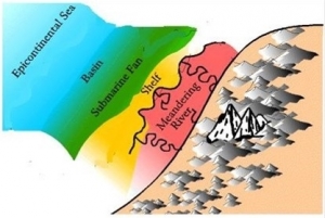
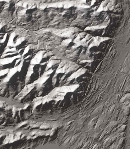
Opus 40, that exotic sculpture executed by Harvey Fite, started out as a piece of art; it may end up being a Saugerties town park. If so, it might be regarded as a “time park” where visitors can travel into the past: 380 million years back to the Devonian age. The original quarry here was cut into a massive Devonian sandstone and that means it cut into a petrified river channel. That’s typical in the Catskills; wherever you see thick sandstones, you can pretty much count on them being the deposits of an ancient river. Such ancient rivers flowed across the world-famous Catskill Delta, the great river delta that deposited all of the sediment that came to be petrified to now make up our mountains.

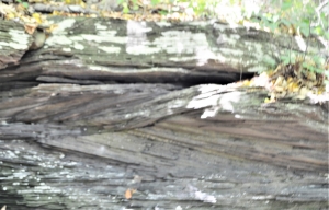
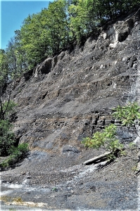
We visited Opus 40 to explore this ancient time. We found 14 feet of fairly continuous river sandstones. It occurred to us that this must have once been a very big river. It had to have been more than 14 feet deep in order to accommodate all that sand. That’s a lot of river! We were getting interested. This river certainly deserved a name and so we decided to call it the “Opus River.”


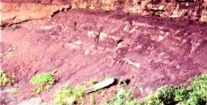
The first four feet of Opus River sediments were made up of flat-lying strata. That is typical of sands deposited well out in the middle of a river’s channel. It suggests a moderate and steady current. We could envision the clear water currents speeding along with a fair amount of sand dancing down the bottom of the channel.

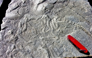
There had once been living creatures in the Opus River. Along the edge of one of Harvey Fite’s walls we found a fascinating fossil. It is not a body fossil, not a bone or shell. Instead, it is something called a trace fossil. This one is a burrow of the animal. We don’t know what kind of animal it was, but worm is a good guess. We found ourselves gazing at the trail of this animal. We were sharing a few minutes in the life of an ancient worm!


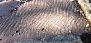
There were few other recognizable fossils; We think that the river currents were simply just a little too powerful for most animals. The strength of those currents became manifest when we found more evidence. There were several horizons of what are called ripple marks. These little ripples were the product of river currents passing across the bottom and sculpting the sand. All in all, a lot of evidence of current activity was turning up in the beds of the Opus River. It had certainly been a busy place.

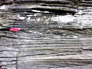
So, by now we knew we were looking at a big and powerful river. That was pretty good, but it would soon get a lot better. Those first four feet of flat-lying strata graded upwards into what is called planar cross bedding. These were strata that displayed a recognizable slope to their strata. That’s unusual; most sedimentary beds are horizontal. These formed as what you might think of as river-bottom dunes. Imagine large masses of sand being swept along by a very powerful flow. The steady current carried the sand along and deposited it on the sloping front of the “dune,” That’s what we were looking at. We are used to seeing planar cross bedding, but we were surprised to see the scale of these deposits; they were big and thick bedded. Once again, we sensed that we were looking at a very deep and powerful river.


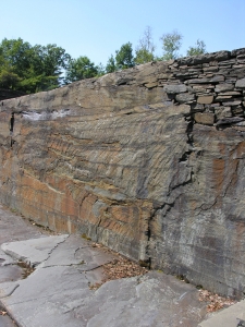
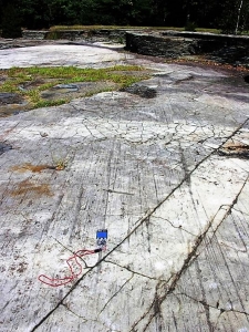
Great rivers are subject to great flood events, and we would find evidence for one of those. We found, on the back wall of the quarry, an erosional surface. This, we suspect, represented moments of the onset of a very big flood. As waters swelled up the banks of the Opus River, the current picked up. Currents cut into the older sediments below and scoured the river bottom. The flood then crested and later its flow abated. As the flood subsided, new deposits of sand filled in the scour surface, hence the feature we were looking at.

This must have been a very substantial flood; we could imagine the raging flow of the river at the peak. We imagined The Woodstock Times with banner headlines screaming about the damage and destruction. But this had been the Devonian time period; there had been no newspapers then. Nobody had recorded these awful floods, and nobody had recalled them until we came along. Geologist read newspapers of stone.

They say that a good sculptor can look into a large stone and see the statue within. We are not sculptors, but we had done exactly that. We had not chiseled an image; we had looked into the rock and seen Nature’s sculpture, already there.

Perhaps it would be better to compare the Opus River to Pompeii, a city frozen in time. Harvey Kite’s river is a petrified stream and, quite precisely like Pompeii, it is frozen in time. Its currents were flowing along and then they stopped in their “tracks” and “froze” into rock. Its ripple marks stopped moving downstream and they have remained in place for 380 million years. Sand grains bounced down the fronts of the river’s dunes, then halted and never moved again, frozen solidly in time. Like citizens of Pompeii, its burrowing animals were caught forever as images in stone. Everything here is frozen in time. That is what sculpture is all about.

Reach the authors at randjtitus@prodigy.net. Join their facebook page at “The Catskill geologist.”

Opus 40 in the Ice Age 7-1-21

in Uncategorized by

An Ice Age Opus?

On the Rocks, The Woodstock Times; April 11, 2011

Updated by Robert and Johanna Titus


Opus 40 is one of the strangest and most truly unique sculptures to be seen anywhere. It was the concept and, perhaps, obsession of Harvey Fite who worked on it from 1939 to 1976 when he died with his boots on, still at work on his creation. The site had been, originally, just another abandoned bluestone quarry in an area with very many of them. If you spend enough time exploring, you can find them all over the place. They lie off in the woods, almost buried in the forests. They are landscape scars, slowly healing from the commercial wounds of a onetime important bluestone industry.

Almost all the others have been left to become overgrown. But Fite had something else in mind. He spent decades moving rocks and boulders around to create his sculpture. Had he been doing this as an inmate at some prison, it would have been a scandalous example of the abuse of “hard labor.” Perhaps Fite might have been among those who protested such an injustice, but he was the one who inflicted this hard labor upon himself. Sadly, he did not live to see his hard labor completed and, in many ways, it remains a “work in progress.” Was this a mission, an obsession, or just what it was supposed to be: a work of art? Who knows, but it’s quite the place to visit.

The current owners (2011) of Opus 40 are interested in selling the property. One proposal floating around is for the town of Saugerties to buy it and turn the place into a park. It’s a controversial notion, especially in these economically depressed times. It’s not any of our business what the people of Saugerties choose to do or not to do, but it is our business to speak of the geology there.

And, in fact, we always like to poke our nose into local affairs – when there is a geological angle, so this was just too good to pass by. We went and visited the site. Our interest wasn’t art; it was the geology. The Opus 40 quarry displays a cross section of all Catskills geological, right there in one spot. It’s one stop shopping for a Catskill geologist.

It’s more than just bedrock; there is a fine glaciated surface that surrounds the quarry. You can circumnavigate the quarry and find yourself walking on a smooth, flat platform of rock. Here we see a wonderful example of what we have sometimes called a “dance floor.” That’s rock surface that was sanded and polished by the passage of the ice back during the Ice Age. Harvey Fite was not the first sculptor to work here. The Hudson Valley glacier got there more than 20,000 years earlier. As the glacier passed across this surface, it dragged along tons of cobble-rich sand and gravel. These materials beveled off the native rock; then the sand ground down the surface and even polished it.

The gravel and cobbles scratched striations onto the polished surface. The striations have a compass direction – south, 20 degrees west – and that speaks to us of the path the glacier took as it headed across the site. We like to stand in such a place and look in the direction that the striations indicate. In our mind’s eyes we can see a barren landscape all around. We stand in a “forest” of bare tree trunks. All of them rise above the ground for 20 feet or more, but none of them have any foliage. These tree trunks are dead; they rise to splintered tops; all have been decapitated by fierce Ice Age gales.

At such a moment we have traveled back to the Ice Age, at least the early stages of that chapter in our history. The climate has suffered from the onset of very cold times. All the trees, and for that matter, all of the rest of the plants have died. There is nothing alive at all, not a mammal, reptile or bird. This is a forest of the dead.

We are the mind’s eyes, the human imagination, and we can do anything we wish. We rise up into the sky a thousand feet and gaze off north, 20 degrees east. There, not all that far away, is the advancing Hudson Valley glacier. It spreads across the landscape and the front of the ice looms tall above the dead forest. This is a dry glacier; it is not melting; it is too cold for that.

But it is moving, slowly, the way a glacier should. And it is advancing toward what will someday be Woodstock. We listen intently and we hear sporadic cracking sounds, slow low-toned grinding noises and loud pops. The brittle ice, shoved from behind by hundreds of miles of more ice, is lurching forward – towards us. Soon, it will help shape the Woodstock that you know today.

Then, suddenly, we return to the present day. We stand at the edge of Harvey Fite’s life’s work and gaze all around. That platform is the focus of our attention. We understand it all so much the better now. It’s a fine dance floor and maybe worth the visit all by itself, but there is more, there is the bedrock. We will visit that in the next article.

Contact the authors at randjtitus@prodigy.net. Join their facebook page “The Catskill Geologist.”

The Marcellus gas

in Uncategorized by

A superpool of gas.

On the Rocks, The Woodstock Times July 8, 2008

Updated by Robert and Johanna Titus


Perhaps you have heard the term “Marcellus Shale” and perhaps you have not, but you will likely be hearing about it many times in the upcoming years. New York State geologists have long known the term, and many have visited outcroppings of the dark shale and sandstone that we call the Marcellus. We have written about it occasionally in Woodstock Times columns over the years. The unit of rock has recently become very important.

Late last year (2007), it was announced by several researchers that the Marcellus might well yield an enormous, absolutely gargantuan, amount of natural gas. Estimates are always just estimates, but people are talking about a two-year supply of natural gas being recoverable from the Marcellus. That’s a lot and, given the circumstances, even the greenest of you will appreciate the pressure to exploit this resource.

What can rightfully be called a “gas rush” has been triggered, and all over the northeast quarter of America the search is on. This is bound to be controversial so, before we go too far, let’s get something straight. We are geologist, and one thing we do is to work to keep you from freezing to death in a cave. So, we are not necessarily opposed to all this, but let’s talk about the science of the Marcellus. There is no possible harm in you coming to understanding the geological story that lies beneath your feet.

It all started nearly 400 million years ago when something you might be tempted to call Europe collided with what eventually became North America. You probably, somewhere along the line, learned about plate tectonics. If you remember some of that, then you will understand the following: The plate collision initiated a crustal uplift which, given time, would produce a great mountain range called the Acadians. Our focus is on the early stages of that collision. There were mountains, but they were not yet very tall. Critically, there was also developing a nearby deep oceanic basin. At its maximum it might have been thousands of feet deep. It covered what now makes up much of the northeastern United States.

Humans have visited modern versions of such environments. In recent decades we have developed the deep-sea equipment to do so. What was once a great mystery is relatively well known today. It is not the least bit unusual for such a marine basin to be very stagnant. There are few, if any, currents that far down. The rising mountains, nearby to ours, were still so small that they supplied very little sediment to the deep. That’s important.

Raining down from above were bits and pieces of dead organisms and this biological material came to make up a very sizable portion of the Marcellus basin sediment. The abyss was so stagnant that whatever oxygen that might have been there was consumed by microbes. Over long periods of time, the resulting stagnant, anoxic seafloor accumulated, thick sequences of organic rich, fine grained sediment. A lot of the biologic matter became the gas methane and that formed the bulk of the natural gas that would be coveted by humans hundreds of millions of years later.

And that is why there is so much interest in the Marcellus. Perhaps you would like to see the unit; it’s not far away. Take Rte. 31 south from Woodstock until you reach the intersection with Rte. 209. Go another 3/4’s mile south and there you will see an enormous outcropping of black shale. This is the Mt. Marion Formation which is an eastern equivalent of the main Marcellus. We found a fair number of fossil shellfish. This does not seem to represent the great stagnant abyss where natural gas would accumulate. So, our guess is that the Mt. Marion will not yield much natural gas, at least not around here.

Farther down the road, near the south end of the outcrop, we found a more finely bedded sequence of black shale. It is made up of very thinly laminated seams of black shale and it displays no fossils. This, we think, is a deeper part of the old basin and it might be that these strata are richer in gas.

If you visit this site, it can be quite an experience, however, to stand along the side of a highway, listen to the traffic, and to realize that this was once the deepest part of the sea. All around you it was once a dark, quiet and cold seafloor. we will have more to say about the Marcellus in future columns; it may be very important geology.

Reach the authors at randjitius@prodigy.net. Join their facebook page “thecatskillgeologist.”

Draining Glacial Lake Woodstock – June 17, 2021

in Uncategorized by

Draining Lake Woodstock

On the Rocks; The Woodstock Times 

Jan. 9, 2009

Updated by Robert and Johanna Titus


We closed last week’s column with a remarkable image. We took you, the readers, west on Tinker Street and then we looked up into the air and saw 280 feet of ice water above us. This was the water of Glacial Lake Woodstock, probably the most important ice age feature in the Woodstock vicinity. We found ourselves at the bottom of this lake with all that ice water above us. That is an astonishing claim.

We left ourselves with the responsibility of proving this notion and today is the day. We would like to not only prove our assertion, but also give you a good example of how we geologists see the landscape as we travel about.  We have a habit of seeing things and noticing things that other people don’t.

Mind you, we usually have to do a lot of exploring before we see these things. Let’s start out west of Bearsville which is also west of Lake Woodstock. On the map there is an interesting pass which hugs the north side of Acorn Hill. You can get there by driving up County Rte. 45, AKA the Wittenberg Road. At the top of the hill is a very inconspicuous bridge.

Bridges are supposed to cross rivers or at least creeks and there is a problem here. There is no water beneath the bridge. This is certainly a bit of a curiosity. But the problems get worse quickly. There is a bit of a valley here, a dry one. You can recognize where stream erosion has cut into bedrock and cut a small canyon. Canyon might be overstating it but there definitely used to be a good flow of water here. All this needs explanation!

We are at the far western end of Glacial Lake Woodstock. Our canyon is dry today, but back at the end of the Ice Age there was a powerful flow here. Lake Woodstock was dammed to the east by a great wall of ice, the Hudson Valley Glacier. It was a time when the climate was warming, and the glacier was melting. The waters of Lake Woodstock had to go somewhere, and it was through this canyon that they flowed. Back then these flows entered into the drainage of today’s Little Beaver Kill.

There must have been a very powerful flow of water. Imagine, all of the glaciers in the region ere melting and much of that meltwater was flowing down Little Beaver Kill. It could not have been all that “little” back then!

When we visited the site, we looked and, in our mind’s eye, we saw the ice age torrent. Today, there is no water at all; we climbed down and walked a few yards along the floor of the old stream. We felt the raging whitewater flow passing beneath us. Back then it would have been certain death to jump into this current. But, as geologists, we are lucky; we can experience the best of both worlds and both times.

Now the point of all this is that this dry canyon lies at 880 feet above sea level. The floor of the Saw Kill Valley is at just about 600 feet. The difference, 280 feet is the depth of the old lake. It was a very deep lake.

The great physicists and mathematicians of the world are often still in their 20’s. Geology is different; it is an experiential science. Its best practitioners are not young hot shots, just out of graduate school. They are, like us, the seasoned veterans who have put in decades of work and are able to recognize features in the landscapes around them. You spend a lifetime absorbing your science and then you see it all around. Believe us, we see the world differently than most.

If you get a chance, please travel up Rte. 45 and see the inconspicuous little bridge. Your mind’s eye is just as good as ours. This is your chance to go back and see the Ice Age.

Contact the authors at randjtitus@prodigy.net. Join their facebook page “The Catskill Geologist.”

Glacial Lake Woodstock – June 10, 2021

in Uncategorized by

A cold bath for Woodstock

The Woodstock Times; On the Rocks; Dec 11, 2008

Updated by Robert and Johanna Titus


We have, off and on, over the past year or so (2008-2009), been journeying through Woodstock’s ice age history. In this column we would like to slow down a little and try to focus on one of the more interesting aspects of this saga: the story of Glacial Lake Woodstock.

Lake Woodstock was first discovered during the middle 1980’s. It was described, briefly, in a State Museum report, but not much work has been done on it. To date, it has only been recognized as a relatively small lake, mostly just to the east of today’s town. It was, we think, much bigger than that. we have been poking around the area and we are now convinced that the lake stretched all the way to Bearsville. It deserves a lot more investigation than it has gotten. Let’s do some of that today.

We have, in an earlier column, claimed that most of the area west of Woodstock formed on the bottom of the lake, and if you travel west down Tinker Street and look to your left and right, you will see the old lake floor as an extensive flat landscape. But there is more, much more. In fact, this all gets to be very interesting to a geologist.

Our descriptions so far, have been of the first Lake Woodstock. There was a second one and that is where we want to take you today. That first Lake Woodstock formed when a glacier, lying just to the east of town, was damming the Saw Kill Valley. The ice dam blocked the flow of the Saw Kill and that created the lake: the first time.

The climate warmed and the glacier retreated back to the northeast and there is a good chance that the first Lake Woodstock drained off to the south. But the Ice Age was a very complex time; its climate was constantly shifting. Under such circumstances a warm period with melting can be replaced by another cold period with a re-advance of the ice. That is what happened. Take a look at the satellite shot. If you view it carefully you will see that the landscape has a streamlined look to it. That streamlining was sculpted by the re-advancing ice. You can actually “read’ the movement of the ice.  It advanced out of the Hudson Valley, from the upper right-hand side of the photo, and pushed on westward. we are not sure how far it got, but we can see streamlining at least as far as west of Bearsville. That means that much of the Saw Kill Valley was, once again, filled up with ice. In fact, when we look at this image, we can convince ourselves that the hills, south of Woodstock are smoothed off and streamlined, more than is the case for the taller Overlook Mountain, to the north. We are guessing that the ice actually overran those southern hills. It seems to have been a major advance of the ice.

We wonder how long such an event takes, but we will never know. And we wonder how long the ice remained, clogging the Saw Kill Valley. we will never know that either. But, given enough time, the climate warmed and the ice retreated from the Saw Kill, one final time. Once again, the remaining ice formed a dam, and that dam blocked the Saw Kill and created the second Glacial Lake Woodstock.

Take another good look at that satellite shot and you will see the flat landscape in the Bearsville area and again, just south of Woodstock. There is still more flat landscape in the area east of Plochman Road. All these landscapes are the floor of Glacial Lake Woodstock. It was pretty big.

One logical question is how deep was it? we alluded to that in a column earlier in the year. we believe, that in the Bearsville vicinity, this lake was at least 280 feet deep. If you are reading this somewhere near Tinker Street, we would like you to look out the window and up those 280 feet and “see” the ice water here. Once again geology has a way of rearranging your sense of reality.  Carl Sagan had something to say about notions such as this. He said that “extraordinary claims require extraordinary evidence.” Providing the evidence for the 280-foot claim will be our responsibility in the next column.

Contact the authors at randjtitusr@prodigy.net. Join their facebook page “The Catskill Geologist.”


I heard that crack – June 3, 2021

in Uncategorized by

“I heard that crack!”

On the Rocks – The Woodstock Times – June 18, 2021

Updated by Robert and Johanna Titus


Being a scientist means that you are going to end up knowing a lot of smart people and I no exceptions to that rule. But we have only ever known a handful of geniuses. One of those is our friend, photographer Vincent Bilotta, who lives in Palenville and works throughout the Catskills. It is hard to define real genius, but you know it when you encounter it. Take a look at some of his photos and you will see.

We had, for years, been trying to take a picture of a geological feature that lies beneath the stone bridge at the top of Plattekill Clove. That’s at a gorge called Devil’s Kitchen, which is one of the most scenic parts of this very scenic clove. It’s dark down there, underneath the bridge, and we just never could get a good picture. Vincent, the genius, not only took a good photo but he produced a great one. He has kindly let me use his image to illustrate today’s column.

The feature we are speaking of is seen left of center in the photo. Take a look and see the structure that looks like a gigantic, petrified bird feather. It’s three or four feet across so don’t worry, no bird produced this. It is what structural geologists, logically enough, call a “plumose structure” and it has quite a story behind it.

The rock it is seen upon is Devonian in age; it is about 380 million years old. It is sandstone and probably its sand was deposited in the channel of a Devonian river. It hardened into rock and subsequently it became involved in one of the great mountain building events in Earth history. That would be the Acadian Orogeny, an event that produced an early version of the Appalachians, called the Acadian Mountains. The rocks we see here were involved in the uplift. They once lay deep within the bowels of those ancient mountains. There were subjected, back then, to truly intense pressures. The rocks you are looking at were, for a long time, buried under a mile or more of bedrock. Imagine the pressure that produced!

Our rocks were squeezed by all that pressure. It is difficult to imagine rocks being compressed but that really can happen. Typically, rocks have a good deal of “give” to them and they can absorb the stress, pretty well. It is much later that they encounter trouble.

The mountain building event we are talking about involved a great landmass, called Avalonia, colliding with North America. That is where the compression came from. It only got worse, later on, when also Africa collided with North America. Mountain building collisions, however, only last so long. Eventually, what happened is that the collision ended, and, in fact, a breakup of the land masses occurred. Africa drifted back to the east toward where it is today. That released all the pressure that had compressed our rocks.

In this new relaxed state of affairs these rocks began to expand back to their original state. That’s when they became brittle, and that’s when the fracturing occurred. You see, a plumose structure is a special type of crack. Essentially, the fracturing begins at the base of the “feather” and expands away from that point. As the fissuring “ripples” through the rock it creates the plumose pattern. Take a good look at the photo, or better yet, go to the bridge at Devil’s Kitchen and see the real thing. You can easily imagine the fracturing passing through the rock.

This was an exciting moment; things happened fast. Some geologists think that the fracturing occurs at something that approaches the speed of sound! And it must have made a lot of noise too; we would imagine a very loud pop or snap. The surface that the plumose structure is on is a flat, nearly vertical plane. That is another aspect of the fracturing. We call such a fracture plane a joint; it is a special type of crack.

All this amounts to another of those most remarkable features, so often found in the rocks. This was not just a little bit of deformation; this must have been a real earth thumping event. For all practical purposes this is a petrified earthquake. Think about that for a moment. You can actually preserve the evidence of an ancient earthquake in the rocks!

And photograph it.

Contact the authors at randjtitus@prodigy.net. Join their facebook page The Catskill Geologist.”


A superpool of natural gas 5-7-21

in Uncategorized by

A superpool of gas.

On the Rocks, The Woodstock Times July 8, 2008

Updated by Robert and Johanna Titus


Perhaps you have heard the term “Marcellus Shale” and perhaps you have not, but you will likely be hearing about it many times in the upcoming years. New York State geologists have long known the term, and many have visited outcroppings of the dark shale and sandstone that we call the Marcellus.


We have written about it occasionally in Woodstock Times columns over the years. The unit of rock has recently become very important.


Late last year (2007), it was announced by several researchers that the Marcellus might well yield an enormous, absolutely gargantuan, amount of natural gas. Estimates are always just estimates, but people are talking about a two-year supply of natural gas being recoverable from the Marcellus. That’s a lot and, given the circumstances, even the greenest of you will appreciate the pressure to exploit this resource.

What can rightfully be called a “gas rush” has been triggered, and all over the northeast quarter of America the search is on. This is bound to be controversial so, before we go too far, let’s get something straight. We are geologist, and one thing we do is to work to keep you from freezing to death in a cave. So, we are not necessarily opposed to all this, but let’s talk about the science of the Marcellus. There is no possible harm in you coming to understanding the geological story that lies beneath your feet.

It all started nearly 400 million years ago when something you might be tempted to call Europe collided with what eventually became North America. You probably, somewhere along the line, learned about plate tectonics. If you remember some of that, then you will understand the following: The plate collision initiated a crustal uplift which, given time, would produce a great mountain range called the Acadians. Our focus is on the early stages of that collision. There were mountains, but they were not yet very tall. Critically, there was also developing a nearby deep oceanic basin. At its maximum it might have been thousands of feet deep. It covered what now makes up much of the northeastern United States.

Humans have visited modern versions of such environments. In recent decades we have developed the deep-sea equipment to do so. What was once a great mystery is relatively well known today. It is not the least bit unusual for such a marine basin to be very stagnant. There are few, if any, currents that far down. The rising mountains, nearby to ours, were still so small that they supplied very little sediment to the deep. That’s important.

Raining down from above were bits and pieces of dead organisms and this biological material came to make up a very sizable portion of the Marcellus basin sediment. The abyss was so stagnant that whatever oxygen that might have been there was consumed by microbes. Over long periods of time, the resulting stagnant, anoxic seafloor accumulated, thick sequences of organic rich, fine grained sediment. A lot of the biologic matter became the gas methane and that formed the bulk of the natural gas that would be coveted by humans hundreds of millions of years later.

And that is why there is so much interest in the Marcellus. Perhaps you would like to see the unit; it’s not far away. Take Rte. 31 south from Woodstock until you reach the intersection with Rte. 209. Go another 3/4’s mile south and there you will see an enormous outcropping of black shale. This is the Mt. Marion Formation which is an eastern equivalent of the main Marcellus. We found a fair number of fossil shellfish. This does not seem to represent the great stagnant abyss where natural gas would accumulate. So, our guess is that the Mt. Marion will not yield much natural gas, at least not around here.

Farther down the road, near the south end of the outcrop, we found a more finely bedded sequence of black shale. It is made up of very thinly laminated seams of black shale and it displays no fossils. This, we think, is a deeper part of the old basin and it might be that these strata are richer in gas.

If you visit this site, it can be quite an experience, however, to stand along the side of a highway, listen to the traffic, and to realize that this was once the deepest part of the sea. All around you it was once a dark, quiet and cold seafloor. we will have more to say about the Marcellus in future columns; it may be very important geology.

Reach the authors ay randjitius@prodigy.net. Join their facebook page “thecatskillgeologist.”

Visions at Boulder Rock, May 20, 2021

in Uncategorized by

Visions of a distant past: The ledge at Boulder Rock

On the Rocks, The Woodstock Times

Robert Titus


Boulder rock has always been one of the most popular destinations for hikers at North/South Lake State Park. You find your way to the Catskill Mountain House site and then take the Blue Trail south and uphill into the forest. It’s a nice, not very difficult climb, and it brings you to near the top of South Mountain. Along the way there are several fine views that can be obtained from sizable bedrock ledges. At a left fork in the trail you hike downhill again and, after a short walk, there it is: Boulder Rock.

There should be a word for a bigger than usual boulder. This one is larger than even the word boulder implies; it must be ten feet tall and maybe 15 feet across. This enormous rock was brought here by an advancing glacier, quite possibly at the peak of the Ice Age. The ice advanced down the Hudson Valley, coming from the north. It had no trouble shoving forward a rock of this size. Glaciers are very powerful; they are used to pushing things around.

If we are wearing the right shoes, we can climb to the top of Boulder Rock and get a much better view. Looking south, we can see Kaaterskill Clove; looking southeast we see the southern Hudson Valley; looking east we see the Taconic Mountains and, finally; looking north we can see much more of the Hudson, stretching almost to Albany.

But it is not today’s scenery that captivates us; it is an image from the distant past. We geologists are like that. When we are standing atop Boulder Rock, we can transport ourselves into the past of some 14,000 years ago. we stand upon the boulder again, but now in a different moment of time, and before us lies the Hudson Valley as it was during the latter stages of the Ice Age. We have arrived here just a few minutes before dawn on a cloudy day. The cloud cover is thin and so a lot of defused sunlight manages to penetrate it. This Ice Age Hudson Valley is cloudy but well lit.

The climate has, in recent times, warmed considerably and the glacier has begun vacating the valley. But there is still a lot of ice out there. An enormous glacier had once been advancing down the Hudson and, at its peak, it had risen up well above the Boulder Rock ledge. In fact, it had overridden all of South Mountain, and North Point too. But recent centuries have seen it melting away.

Still, the valley remains almost filled with ice. The glacier is almost 2,000 feet thick out there, just a short distance to the east. And, stretching beyond that, the ice reaches all the way to the Taconic Mountains on the other side of the valley, a distance of many miles. Those mountains rise above the glacier. They lack much in the way of color. They can only muster a darker shade of gray, enough to contrast with the glacier. The ice is also gray, but mostly a lighter tint of that dull “color.” As it has melted away, soot has been brought to the surface to discolor it.

The surface of the glacier is irregular; here and there we can see shallow pools of water. These never get very big; they always find a way to drain down into the ice below. The bottom of the glacier cannot be seen, but it is very wet down there. The glacier is broken by great fissures; these originally formed as crevasses, back when the ice was still advancing to the south. The brittle ice could not stand the strain of movement and it gave way and fractured. But that was long ago; now the old cracks have lost their once sharp edges. These have gradually melted away. Warming climates have taken a toll. The glacier has an aged look to it.

Time passes and the rising sun has broken through the thin cloud cover and now sunshine radiates across the entire vista. As the sun continues its ascent, the ledge all around basks in its warmth. Even in these cold times the sun can warm things up. Some of that radiation is reflected downwards. That is probably why there is a great gap between the boulder rock ledge and the ice below it. Sunshine has melted away the nearby ice to open up this yawning chasm. The hours pass by and soon it is midday. Now it can be seen that the sunlight is shining directly into the gap and its walls of ice have become shiny with fresh meltwater.

But this day will last no longer than any other; the sun continues its inevitable traverse off to the west. Near the end of the afternoon, it disappears into another bank of clouds, much thicker this time. Now the weather changes quickly; it grows windy and cold. Soon a heavy snowfall begins. By early evening, a thin bank of snow has drifted up against the western side of Boulder Rock.

Past midnight the skies clear, the winds die down, and it grows truly frigid. The stars are bright, even in this night’s full moon. For long hours before the next day’s dawn, the Hudson Valley is illuminated in the moon’s spooky silvery light. Cold, silent and dead, it is a wondrous sight to behold.

Contact the authors at randjtitus@prodigy.net. Join their facebook page The Catskill Geologist.”.


Stream Piracy in Kaaterskill Clove

in Uncategorized by

Piracy in the Catskills

On the Rocks – The Woodstock Times

Updated by Robert and Johanna Titus


Kaaterskill Clove attracts thousands of people every year just to enjoy the scenery. They hike and climb along the clove trails. They visit the waterfalls. They walk up the canyon. On it goes, there are so many recreational things to do here. The clove is well known regionally, and you might not expect this location to be known internationally, but it is. But when we say internationally, we should be a little bit careful about what we imply. You see, the clove’s international fame is within the world’s geological community. Kaaterskill Clove became geologically famous about a century ago when something special was discovered about its landscape. This, it turns out, is just about the best place anywhere to go and see something called stream piracy.

Stream piracy must sound like a most unlikely term. Try to imagine a river with an eye patch, a sword, a parrot on its shoulder and a Jolly Roger flag; it doesn’t work. If you prefer, we can mention other terms we use, like beheaded stream or barbed drainage, but neither of them does much good in explaining itself. Clearly, we need some definition here. Take a good look at a map of the drainage in the Kaaterskill Clove vicinity. There is something most peculiar. Gooseberry Creek, which flows west from the clove area, is not part of the clove. Instead, it begins in Haines Falls and flows into Schoharie Creek. Lake Creek, which does form the head of Kaaterskill Creek has a peculiar pattern. It begins at South Lake and flows westward, as if to join the Schoharie Creek system. But instead, it makes a very sharp turn, tumbles off of Kaaterskill Falls and then enters the clove drainage.

All this is very strange looking on a map. Lake Creek and its tributary, Spruce Creek look like they should be part of the Schoharie drainage, indeed they should be the head of that river system, but they are not. They have been diverted eastward and flow into Kaaterskill Creek. (see heavy black line) Thus, it makes sense to say that the Schoharie system has been “beheaded.” The confluence of Lake and Kaaterskill Creeks is at a very sharp angle: That is called “barbed drainage” and that term does make sense. But why and how did all this happen? That’s where the term stream piracy is needed.

Stream piracy was described here about a century ago by N.H. Darton. He noticed that Kaaterskill Creek flowed down a very steep slope. With all of the momentum that the water developed, it was no surprise that the creek was highly erosive. Its erosion has created the rugged and picturesque landscape that we see here and enjoy so much. That’s a beauty that the members of the old Hudson Valley school of art referred to as “sublime.” But the Schoharie Creek system, including Gooseberry Creek, is not on a steep slope, and it is not very rapid or erosive. Its valley is nice to look at, but it isn’t very rugged, and it is not “sublime.”

The stream piracy, we see here, began at the end of the ice age. Kaaterskill Creek began attacking the steep slopes of the eastern Catskills that had been left by the erosion of the Hudson Valley glacier. As it gouged its canyon into the Catskills, it encountered the upper reaches of the Schoharie Creek drainage. Kaaterskill Creek cut right into that system and has diverted some of the drainage and turned old Schoharie tributaries eastward into its own canyon. The diversions are seen at the sharp turns in the streams, the barbs in the drainage. This is stream piracy, and it will continue. In the future more of the upper Schoharie will be lost to a greedy and expanding Kaaterskill Creek.

The process will continue on into the future until our steep Catskill Front is eroded back into a gentle slope. It will lose most of its majesty in the process but there is little cause for alarm. This will not happen for many millions of years.

   Contact the authors at randjtitus@prodigy.net/ Join their facebook page “The Catskill Geologist.”

The old mountain turnpike Ar. 29, 2021

in Uncategorized by

The Old Mountain Turnpike

On the Rocks – The Woodstock Times

Updated by Robert and Johanna Titus


One of our region’s most historic roads is also one of its least known. It’s the Old Mountain Turnpike. Long ago, the road was the gateway to the Catskills. As far back as the 1820’s guests of the famed Catskill Mountain House Hotel took carriages up the pike to get to the hotel. As the hotel prospered, so did the turnpike. When the hotel got even more successful, it built the Otis Elevated Railway right up the Catskill Front, and the old dirt road slowly fell into disuse. Today the once great turnpike is just a horse and hiking trail, but it still has much of its 19th Century atmosphere. It makes a nice walk in the woods and, of course, along the way there are many rocks.

To get to the Old Mountain Turnpike take Rte. 23A into Palenville. Turn onto Bogart Road and head north to Mountain Turnpike Road where you turn left, the trailhead is at the western end of the road. You can hike all the way up to North Lake State Park if you like, or any part of the way. You don’t have to go far however before you are in the thick of the geology. The road climbs, makes a bend, and then a fine outcropping of reddish rocks appears. This is great Catskill Delta of the Devonian age. Such red strata are old floodplain deposits, silts and clays left by ancient floods and hardened into red shales. The darker deposits are the muds of delta backswamps. Away from the river channels, swamps formed in low-lying areas and those dark muds accumulated. Watch for fossil plant fragments in all of this.

As you continue up the road you will encounter, at frequent intervals, a number of sandstone ledges. They are Devonian river channel deposits, composed mostly of sandy strata that dip one way or another. These are called cross beds and they are the products of ancient river currents. The river currents drove masses of sand into large “dunes” which migrated downstream. Most of those cross beds dip to the northwest as that was the direction that the old rivers flowed. In between the sandstone ledges the road tends to be pink or red. These are hidden floodplain deposits. The pattern is clear: river sands are followed by red floodplain shales and then more river sands and so on. The Catskill Front is like a great building, it’s made up of sandstone and shale “stories.” When we make such a hike, we almost always count those stories.

The second story had some prominent ripple marks in a layer of red shale that crossed the road. The ripples record breezes that blew across a shallow delta pond and generated currents that, in turn, created the ripples. Incredibly those ripples are the record of breezes of nearly 400 million years ago.

At the fourth story we found a vertical ledge of sandstone that had been scoured and striated by a passing glacier. This event occurred a mere 20,000 years ago. A twinkling of time compared to the age of the rocks themselves.


The 14th story was a massive sandstone. This must have been a very large river. Such rivers were what are called delta distributaries. In a large delta complex the trunk stream splits up into many such distributaries. Each one meanders back and forth across the delta plain. A river that is here today, may be gone tomorrow, replaced by a floodplain. That’s why these river sandstones alternate with red floodplain shales. Look at a map of the Mississippi Delta and you will see good examples of such distributaries. Then look at a map of the Ganges River Delta of Bangladesh and you will see even better examples.


The road ascended into a place called Sleepy Hollow and then made a sharp left bend. Here had once stood the Rip Van Winkle House; it had been the halfway stop for carriages headed up to the hotel. The hollow was naturally air conditioned with cool mountain breezed descending through it. It must have been a nice place to stop. But what impressed us most was just above, one of the largest, thickest stories of the hike. We thought that this must have been one of the greatest rivers of the Catskill Delta.

The 24th story brought us to a great overlook. The trees have been cleared away here and a picnic table set up. We ended our journey and sat and gazed out at the Hudson Valley. We had seen enough history for one day. We had watched as 24 Devonian rivers and one glacier had crossed this location. History is complex.


Contact the authors at randjtitus@prodigy.net. Join their facebook page “The Catskill


Geologist.”

1 13 14 15 16 17 41
Go to Top