"I will never kick a rock"

Category archive

Uncategorized - page 5

Some fossils from a reader July 14, 2023

in Uncategorized by

Our reader’s Rocks: Mt. Tremper fossils

The Catskill Geologists

Robert and Johanna Titus


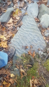
Robert and Johanna: Attached are some photos of fossils I found at Mt. Tremper. I would love to know more about them Linda Senft


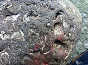
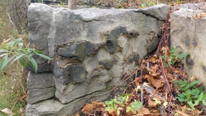
   Linda: Thanks for your photos. We enjoy getting things like this in our email. We too, have spent time exploring the Mt. Tremper vicinity. We described the stone used in building the Zen Mountain Monastery there in one of our recent Kaatskill Life articles. In many ways your fossils seem unremarkable. These are just commonplace fossils, found throughout our region. And, as is also common, none of them are especially well preserved, most of them are just broken fragments. But, we don’t want to do an injustice to these ancient animals; there is so much more.

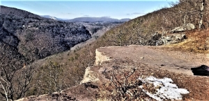
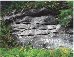
The gray rock in which they are petrified is, without any doubt, limestone. That, all by itself, conjures up quite some fine images. Limestone almost always forms on the floor of a shallow, tropical sea. The best examples that we know of, are found in the Bahamas, or off the western coast of Florida. Have you been? If so, then you can conjure up images of shallow, sparkling, aqua-colored seas. If you look around Mt. Tremper, you will quickly see that things have changed!

The fossils that we can identify are the ones with ridged surfaces. These are animals, shellfish that are called brachiopods. We described and illustrated them earlier this year, in our June 16th article. Brachiopods are a group of shellfish that you should acquaint yourselves with; they are enormously common in Devonian marine sedimentary rocks. Wikipedia can help you a lot.

Brachiopods are still alive, but there are only a few hundred species still found.
There are tens of thousands of species in the fossil record. The Devonian time period was a very good stretch of time for these invertebrate animals. We find thousands and thousands of them here in the Catskills so, you can see why we urge you to become knowledgeable of them.

During the Devonian, brachiopods littered the floor of the Catskill Sea. They lived simple lives; they drew water into themselves and filtered bits and pieces of nourishing biological materials out of that water. That was their food. They are called filter feeders. It wasn’t exciting but they got by just fine.

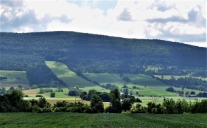
In many ways, what makes your fossils even more interesting is where you found them. Mt. Tremper is composed and sandstones and shales that accumulated on the Devonian Catskill Delta. We have written about that from time to time. We promise you, these brachiopods did not live on the dry lands of the Catskill Delta.

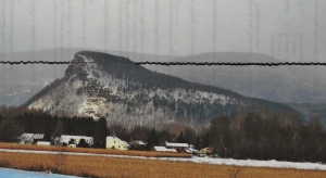
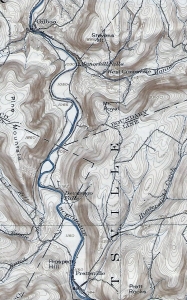
Those limestones, your fossils were found in, were also not formed on a delta; they formed in that shallow sea. These limestones belong to a unit of rock called the Helderberg Limestone. It is found up and down the Hudson Valley and also along the southern flank of the Mohawk Valley. It is found in Mt. Tremper, but it is buried under a few miles of sandstones and shales. These limestones did not work their ways to the surface; they were brought to Mt. Tremper by glaciers.

If you look at a map you can soon trace the likely path they took to get to Mt. Tremper. We know that glaciers came down the Hudson Valley. Along the way, the ice scooped up these rocks from exposed Helderberg limestone outcrops. We know some of the ice turned west and rose up the valley of Esopus Creek. These limestones were dragged to Mt. Tremper and that is where the Ice Age ran out of steam. The climate warmed, the glaciers melted, and these rocks were left behind as part of the debris of a major glaciation.

Well, at first glance, we found these fossils to be “unremarkable” but after thinking a little while, we believe they tell us a wonderful story, a story about an ancient tropical sea and a not quite so ancient ice age glacier.

Linda, now you know more about your fossils.

Contact the authors at randjtitus@prodigy.net. Join their facebook age “The Catskill
Geologist.” Read their blogs at “thecatskillgeologist.com.” You can find them in Kaatskill Life magazine and sometimes in the Woodstock Times. They are just about everywhere!

A landslide across the river July 13, 2023

in Uncategorized by

Landslide hazards?
The Catskill Geologists                                                                                         Robert and Johanna Titus                                                                                          The Mountain Eagle; Dec. 8, 2017


Did you hear the news of the recent landslide, across the Hudson in the town of Greenport? It occurred at the Sons and Daughters of Italy Club on Bridge Street, right along the banks of the Claverack Creek. Several hundred yards of earth slid into the creek. This was something called a rotational slump. A large mass of earth becomes unstable. Then a sizable curved fracture opens up and the whole overlying mass slides downhill. The slide follows the fracture in a rotational fashion, hence the name. When all is done, a nearly vertical cliff is left behind at the “head” of the slide. See our photo. The bottom, or “toe” of the slide, is a chaotic mass of earth that might very well dam any stream that lies below it. That happened at Greenport and a lot of engineering had to be done on the fly in order to keep Claverack Creek from flooding its own valley.

What surprised us was that the same stretch of the Creek had seen a very similar slide only 11 years ago. We covered the story for another newspaper that we wrote for back then. The surprise wasn’t so much where and when the slide happened but in other things.

Back in 2006, just before the first slide, there had been a long period of heavy rainfall.
We had been watching this, and we saw problems developing. We reasoned that the heavy rainfall would soak into the ground and destabilize all the lake deposits along river banks such as on the Claverack. You see, that river flows across the deposits of a large glacial lake. At the close of the Ice Age, the lower Hudson Valley had been flooded by the waters of something called Glacial Lake Albany. The lake basin accumulated thick sequences of silt and clay. If you visit the Greenport vicinity, watch for all the flat landscape. Those lands formed on the floor of the lake.

Rivers, such as the Claverack, have an easy time cutting through such deposits.
They can cut steep banks into the lake deposits and that’s part of the problem. The difficulties really begin when rainfall picks up. Water soaks into the lake deposits and they start to weigh too much. The water makes them too heavy and it also makes them somewhat fluid. Those fractures form and then, abruptly, the slide occurs. We suspect that the slides are very quick, but we have never heard an eyewitness report so we don’t know for sure.

Our greatest surprise with this slide is that it did not occur during a particularly wet season. It just has not been raining all that much in the year of 2017. Those lake deposits could not have weighed all that much, and they would not have been very fluid. So, why did the slide occur? We don’t know and that alarms us.

Contact the authors at randjtitus@prodigy.net. Join their facebook page “The Catskill Geologist.” Read their blogs at “thecatskillgeologist.com.”


Landslide hazard? 7-6-2023

in Uncategorized by

Landslide hazards?
The Catskill Geologists                                                                                         Robert and Johanna Titus                                                                                          The Mountain Eagle; Dec. 8, 2017


Did you hear the news of the recent landslide, across the Hudson in the town of Greenport? It occurred at the Sons and Daughters of Italy Club on Bridge Street, right along the banks of the Claverack Creek. Several hundred yards of earth slid into the creek. This was something called a rotational slump. A large mass of earth becomes unstable. Then a sizable curved fracture opens up and the whole overlying mass slides downhill. The slide follows the fracture in a rotational fashion, hence the name. When all is done, a nearly vertical cliff is left behind at the “head” of the slide. See our photo. The bottom, or “toe” of the slide, is a chaotic mass of earth that might very well dam any stream that lies below it. That happened at Greenport and a lot of engineering had to be done on the fly in order to keep Claverack Creek from flooding its own valley.

What surprised us was that the same stretch of the Creek had seen a very similar slide only 11 years ago. We covered the story for another newspaper that we wrote for back then. The surprise wasn’t so much where and when the slide happened but in other ways.

Back in 2006, just before the first slide, there had been a long period of heavy rainfall.
We had been watching this, and we saw problems developing. We reasoned that the heavy rainfall would soak into the ground and destabilize all the lake deposits along river banks such as on the Claverack. You see, that river flows across the deposits of a large glacial lake. At the close of the Ice Age, the lower Hudson Valley had been flooded by the waters of something called Glacial Lake Albany. The lake basin accumulated thick sequences of silt and clay. If you visit the Greenport vicinity, watch for all the flat landscape. Those lands formed on the floor of the lake.

Rivers, such as the Claverack, have an easy time cutting through such deposits.
They can cut steep banks into the lake deposits and that’s part of the problem. The difficulties really begin when rainfall picks up. Water soaks into the lake deposits and they start to weigh too much. The water makes them too heavy and it also makes them somewhat fluid. Those fractures form and then, abruptly, the slide occurs. We suspect that the slides are very quick, but we have never heard an eyewitness report so we don’t know for sure.

Our greatest surprise with this slide is that it did not occur during a particularly wet season. It just has not been raining all that much in the year of 2017. Those lake deposits could not have weighed all that much, and they would not have been very fluid. So, why did the slide occur? We don’t know and that alarms us.

Contact the authors at randjtitus@prodigy.net. Join their facebook page “The Catskill Geologist.” Read their blogs at “thecatskillgeologist.com.”

Manorkill Falls – June 29, 2023

in Uncategorized by

The Depths (?) of a sea,

The Catskill geologists,

The Mountain Eagle, Dec. 1, 2017

Robert and Johanna Titus


Have you ever been to Manor Kill Falls? You take Rte. 30 to where it intersects Rte. 990-V and then you head north a few miles and then watch for the signs. They have a fine parking lot and then you have a choice of trails. The upper trail heads for the top of the falls, but we want you to take the lower trail. That one takes you down to the bottom of the falls where you get a fine scenic look at it. That’s where the best geology is too.

You stand at a good location and look up at the falls. If you have an eye for rock types then you will recognize a sequence composed mostly of thinly bedded black shales. These strata are interrupted with the occasional dark sandstone. That’s a good start but now you need to get a better look at these rocks. You can do that by looking down; the ground is littered with rocks. A thin “shingle” of black shale will reveal a very fine-grained sedimentary rock; it is composed of silt and clay. None of those grains are large enough to be seen. It is black from all the organic matter in it – the stuff of ancient life.

It is natural for a geologist to begin looking for fossils. Those provide the clues for figuring out exactly what kind of environment is represented here. The hunting was disappointing at first but, after a short while, the fossils of some shellfish were turned up. These were creatures called brachiopods. Like clams, they have two shells, and like clams, they spent all of their lives lying on the seafloor. But they are not clams; they have a very different anatomy, so different that they are not even distant cousins of clams.

Nevertheless, these brachiopods are marine animals, and they tell us that all the strata we are looking at were formed, about 390 million years ago, at the bottom of something that is often called the Catskill Sea. Stand back at look up again. Each horizon of stratified rock once took its turn being the floor of that ocean.

Well, now we know something important; The Manor Kill Falls location was once the bottom of a large ocean. The next question that comes to mind, to a geologist anyway, is “just how deep was this ocean?’ We can’t throw a plumb bob overboard so just how do we determine this important bit of information. The answer is that we don’t, we can’t. But we can make some approximations.

Here’s how we do that? We have already looked those lithologies over and we have found that most of the bedrock here is fine grained black shale. That’s a type of rock that forms in relatively deep waters. The black color speaks to us of a relative scarceness of oxygen on that sea floor. That black biologic material would have decayed away if there had been oxygen. We did not find many fossils so not too many shellfish lived down there.

We thought we were building a case for a very deep-sea environment, but then we found something else. That something else was downstream. There we saw a slab of rock covered with what are called ripple marks. Take a look at our photo. These are slightly asymmetrical ripples and that indicates that these were sculpted by currents passing across that sea floor. What does that mean? Ripples are rare in very deep waters. It means that this seafloor was not all that deep.

We stood on that slab; we were literally standing on the bottom of an ancient sea. We looked up and, in our mind’s eyes, we could see the dimness of just a little sunlight that had reached down to this seafloor. It just wasn’t that deep.

Contact the authors at randjtitus@prodigy.net. Join their facebook page “The Catskill Geologist.” Read their blogs at “thecatskillgeologist.com.”


A View Back Through Time, June 22, 2023

in Uncategorized by


An image of the past – the Schoharie Creek Valley

The Catskills Geologists. Mountain Eagle, 2017

Robert and Johanna Titus.


We love to drive around in the Catskills. There is always so much scenery to see.
Even at 55 miles per hour you can look and see so much, at least the passenger half of our marriage can. But sometimes – no frequently – we feel the need to stop and get out so that we can stand along the side of the road and just gaze – into the past. Let’s do that in this week’s column.

Our journey will take us to the Schoharie Valley, midway between Middleburgh and Schoharie itself. There we find a special sort of imagery. Take a look at our photo. We are looking east from Rte. 30. In the distance is a hill with the unlikely name of “Rundy Cup Mountain.” In the middle foreground is the valley floor of Schoharie Creek. It’s pretty, don’t you think? That valley floor is remarkably flat and that is important, but first let’s concern ourselves with Rundy Mountain. We want you to look again and notice something you might have missed the first time.

There are sharp boundaries between agricultural fields and forests on the slopes of
Rundy Cup Mountain. And those sharp boundaries define a nice curvature to the lower slopes of the mountain. There is not a trained geologist in the whole world who would not immediately see what we saw. We looked, and then turned around and looked west; we saw the same curvature on that side of the valley. That curvature defines what we call a U-shaped valley.

And that is the dead giveaway to the valley’s long ago history. A U-shaped valley, like this one, is always the product of a valley glacier. We looked again and, in our mind’s eyes, we gazed into the past and saw the Schoharie Creek Valley filled, almost to the top, with a glacier. Our mind’s eyes rose up into the sky and we looked down on it. We had returned to an episode of time, late in the Ice Age. We looked south, and we saw that glacier, confined by the valley walls, and moving like a river of ice, south through the valley. The white surface of the ice was fractured by great, dark, curved crevasses. These curvatures betrayed a southward motion to the ice.

We, the mind’s eyes, paused a full thousand feet above the ice. It was a warm day, by ice age standards. Meltwater, in abundance, had accumulated beneath the ice, and it was lubricating that southward motion. We hung in the air and listened; we heard creaks, and groans emanating from the moving ice below us. From time to time, great, explosive, cracking, echoing sounds followed. On this day the brittle ice was advancing at the almost unheard of pace of 100 feet per day!

It had been a clear ice age mid-June morning, but now it was late afternoon. The sun shined down directly on the ice and a thick ground fog had formed. The fog rose up and enveloped us; we could no longer see the glacier.

When the fog finally cleared, it was very late in the day, but it was a very different day. We, the mind’s eyes, had traveled centuries forward through time – the mind’s eyes can do that. We had arrived at a time, long after that valley glacier had melted away. Now, the entire bottom of the Schoharie Creek was filled with a sizable meltwater lake. Its waters stretched out as far as we could see to the north and to the south. Beneath those waters, sediments of silt and clay were accumulating.

Now we were able to put together the whole story of this part of the valley. Those curved valley slopes had been sculpted by the passing ice; the flat valley floor was younger; it dated back to the level bottom of that post glacial lake.

Contact the authors at randjtitus@prodigy.com. Join their facebook page “The Catskill Geologist.” Read their blogs at “thecatskillgeologist.”

Time and Stratigraphy at Kaaterskill Clove. 6-15-23

in Uncategorized by

A Journey through time in Kaaterskill Clove

The Catskill Geologists; Nov. 2017

Robert and Johanna Titus


Have you ever hiked the north rim trail at Kaaterskill Clove? It’s one of those many great experiences that anyone living in the Catskills should have done – perhaps, like us, many times. Better still, it’s something you should take visitors to see. When we go there, we stop at Sunset Rock and look down about a thousand feet or so, and gaze into the distant past. Way down there, about 15,000 years ago, was a raging, foaming, pounding, thundering, whitewater torrent. Those were the waters of the melting glaciers of those late ice age times. That flow did most of the work of carving Kaaterskill Clove. That’s what makes this truly a geological wonder.

But there is still an older time, represented down there. Down in the very depths of the canyon, there are stratified sandstones and shales. The canyon is about a thousand feet deep here, so there must be an equal amount of stratified rock. Those rocks are middle and late Devonian age, which makes them about 385 to 375 million years old – that’s in very round numbers. It’s natural for geologists to ponder such vast numbers. We are pros; we are professional scientists, and we are not supposed to wax poetic about such things, but – we just can’t help it.

The two of us began to wonder just how many years had passed by from when the oldest strata, at the bottom of the Clove were deposited, to when those at Sunset Rock came to be. We got out some publications from the New York State Museum and began to make some “guesstimates.” We are only going to make some gross approximations today; so don’t hold us to any of our numbers. We just want to give you a notion of when all the stratigraphy at Kaaterskill Clove came into being, and how long it took to be deposited. If somebody thinks they can come up with better numbers, we welcome them.

We think the strata at the bottom of the canyon belong to a unit of rock called the Plattekill Formation. The Plattekill is a unit of gray and brown sandstone. The New York State Museum places the middle Plattekill at about 385 million years in age. We think the top of Kaaterskill Clove corresponds with the top of the Oneonta Formation, a largely red sandstone, and that makes it about 381 million years in age. The math is pretty easy; we get about 4 million years of time represented from the bottom to the top of the clove’s stratigraphy. Remember those 1,000 feet that the canyon encompasses? Well, we divide through and we get about 4,000 years per foot of stratified rock.

Now, none of this is great science, and none of it is great math. A foot of river sandstone might have been deposited in a few hours. A foot of red shale may have taken many, many thousands of years to form. There must have been sediments from vast expanses of time that were eroded away and lost forever. Other great lengths of time just never saw any deposition at all. But, we think we have come up with some reasonable approximations and that is all we are aiming at.

Again, stand atop Sunset Rock and look down those thousand feet. See 4,000 years of time for every foot below you.

Contact the authors at randjtitus@prodigy.net. Join their facebook page “The Catskill                Geologist.” Read their blogs at “thecatskillgeologist.com.”


Some flint nodules 6-8-23

in Uncategorized by

Our reader’s rocks: the origins of flint.

The Catskill Geologists

Robert and Johanna Titus


Dear Bob and Johanna: My husband and I were out exploring north of Rte. 145 (near intersection of County Rtes. 443 and 156) in Berne when we found an interesting outcrop. One of the rock strata had peculiar black masses within it. I am sending a photo. Can you tell me what this is? Debra Teator, Freehold.

Thank you Mrs. Teator. You did the right thing sending us a photo. They can be very helpful. We can’t always identify geologic features from a photo, but this time we can. The gray rock surrounding those black masses belongs to something called the Helderberg Limestone. We expect to be writing a lot about the Helderberg as it is a very important local unit of rock. Its most important aspect is that it takes us back about 400 million years to a time when almost all of our region lay beneath the waters of a shallow tropical sea. If we could transport you to that Helderberg Sea, you would look around and swear that you were in the Bahamas.

The Helderberg Limestone is very well exposed at John Boyd Thacher Park, and we did not know of your outcrop in Berne. The Helderberg is composed of several subunits called formations, and this one is the Kalkberg Formation. Its sediments were deposited well offshore, in waters that were certainly not deep but might be best described as subtidal. If you were at the bottom of the Kalkberg Sea during the daytime, then you could look up and probably see a lot of sunlight.

Now, what is chert and how did it form? Chert is described as being microcrystalline quartz. That makes one of nature’s most common types of minerals: quartz. But, unlike normal quartz, its crystals are extremely small. That’s the easy part; what is harder is figuring out exactly how it formed. Late at night, in geology bars, this has always been the subject of debate. We will tell you our best understanding.

The first thing that happened is that the sediment that makes limestone was deposited. This stuff consisted of very small grains of calcium carbonate (CaCO3). Most of those grains had previously been parts of the shells of shellfish. Clams, snails and other shell-bearing organisms had died and their skeletons had broken up into grains of sand, silt and clay.

After this sediment had been deposited but before it hardened into rock, it was affected by chemical processes. If we understand it properly, water rich in dissolved silica (SiO2), was being squeezed out of the soft, wet sediments. When the dissolved silica reached layers of sediment that had a low pH, which is also known as a high acidity, then the microcrystalline quartz crystalized as chert. The chert formed into globs which are commonly called chert nodules. If the nodules grew large enough and were abundant, then they would grow into each other and form strata of chert. That is what is seen in the photo.

So, today’s journey into the past has taken us into 400 million year old sediments and allowed us to watch the formation of chert. This material is better known to most people as flint. That’s the stuff that Stone Age cultures learned to fashion into stone tools, such as arrowheads. It also functioned in flintlock rifles.

Contact the authors at randjtitus@prodigy.net. Join their facebook page at “The Catskill Geologist.” Read their blogs at “thecatskillgeologist.com.”

   Have you found some geology we might want to write about? Send us a pho

A Devonian Stream at North Lake 6-1-23

in Uncategorized by

An ancient river channel

The Catskill Geologists

The Mountain Eagle Oct. 20, 2017

Robert and Johanna Titus


Every so often, in our columns, we refer to a sizable ledge of sandstone as being the cross section of a Devonian age stream channel. The Devonian part is easy; all of the bedrock in the Catskills is Devonian in age (419 to 359 million years ago). But what about the stream channel part? How, exactly, is it that we know that?

It’s a fair question and we think we should take a crack at answering it. Let’s do that this week. Recently we were over at North Lake, on the Catskill Front. Our primary interests on that day was the ice age history of the land that lies between North and South Lakes. But, we came across a massive ledge of light colored sandstone and it caught our eyes. We took a good look and a good photo. We had seen some interesting structures within the sandstone.

Well, what we had seen were a number of erosion surfaces. We printed up our picture and then inked in those erosions. Take a look at our photo. This had been a sizable river. Its sandstones must be twelve feet or so in thickness. You need a river pretty much that deep just to accumulate all that sand.

This river lay at the bottom of the steep slopes of a mountain range. These were called the Acadian Mountains and they towered above what is now western New England. Streams, that descended their slopes, would have flowed out onto what we call the Catskill Delta. They carried a lot of sediment, most of it sand. These sands came to be deposited where North Lake is today.

These were likely large and powerful streams. They would have been occasionally subject to great flooding events. It is only logical to think that, from time to time, it rained a lot up in the Acadians. Those storms generated powerful flows of water, carrying large amounts of sand. When the streams flowed far enough out onto the delta then their flows slowed down and the sand came to be deposited.

If all that is true, then we should see the evidence in outcroppings, such as the one in our photo. We think that the evidence is there – in the inked lines. Each flood event must have reached a peak, when the flows were at their maximum levels. Those flows, it only seems logical, would have eroded into the sediments of the stream channel. When we inked in those erosional surfaces, we thought we had identified such events. The bottoms of these surfaces are concave and they, each one of them, look like features that had been eroded.

There are at least four of these erosional surfaces in our outcrop, or about one every three feet. We think that each of these surfaces records the peak of a major flood event. During that peak, the flood currents would have picked up large amounts of sand and swept it away. As the flood passed its peak, currents slowed down and most of that sand would have come to rest as a new deposit. Most of the sand in between these erosion surfaces seems to have been deposited at the end of its flood or during quiet times that followed.

How often did these floods occur? We can come up with a very approximate estimate. There are about 4,000 feet of sedimentary rock found in this Devonian sequence and it took about 11 million years to deposit them. That averages out to about 2,700 years per foot of sedimentary rock. If there were three feet per flood and if all the above is true, that means that these floods occurred every 75,000 years or so! That’s a lot of time.

But, most importantly, all this is consistent with the notion that such sandstone ledges were once stream channels.

Contact the authors at randjtitus@prodigy.net. Join their facebook page “The Catskill Geologist.” Read their blogs at “thecatskillgeologist.com”

Vroman’s Island 2-25-23

in Uncategorized by

Vroman’s Island

The Catskill Geologists Sept. 2017

Robert and Johanna Titus


We do a lot of poking around, here in the Catskills, and we wind up learning the darndest things about the area’s geology. Let’s do one of those in this week’s column. Let’s start by taking you to Middleburgh. Some time ago we described the fact that the bottom of the Schoharie Creek valley, south of town, is underlain by the silts and clays of an old ice age lake.

About 14,000 years ago, the whole valley here lay beneath the waters of that deep lake. It has been, logically enough, called “Glacial Lake Schoharie.” The flat valley floor, hereabouts, is the bottom of that lake. Most of the time, the waters of a typical lake have a drain which takes them on a journey toward the nearest ocean. Geologists have discovered that the Lake Schoharie drain passed down the Catskill Creek Valley on its way to the Hudson drainage basin. Today Rte.145 follows this path. If you get a chance to drive down this valley, we would like you to imagine the powerful whitewater torrents that once filled up all of its lower parts. Those waters had been in Lake Schoharie, but they had poured into today’s Catskill Creek.

The top of the Catskill Creek Valley lies at an elevation of 1,180 feet at the Village of Franklinton. That level formed a dam for the waters of Lake Schoharie. When Geologists look at the Schoharie Creek Valley, in their mind’s eyes they fill it up to the 1,180 foot level. The floor of the valley lies at an elevation of about 640 feet so, if you do the math. Okay, we will do it; the lake was 540 feet deep! That’s a lot of lake; the next time you are driving south from Middleburgh, look up and imagine all that ice water rising above you.

Well, we had figured all this out and that was when we got to that “darndest” thing. We were looking at our Middleburgh topographic map over, and we noticed that Vroman’s Nose rose to an elevation of about 1,250 feet. Have you ever hiked to the top of the Nose? We hope so, Vroman’s Nose is a hill that is found a short distance southwest of Middleburgh. It looms above the valley floor. It is a very distinctive landscape feature with a towering cliff facing the south. If you have been up there, then you have seen the absolutely wonderful view from that top.

But we had made that darndest discovery. The top of Vroman’s Nose rises about 70 feet above the old lake level. That means .that way back then, this was not Vroman’s Nose; it had been Vroman’s Island.

We hope you will get a chance to visit Vroman’s Nose sometime soon. It’s a town park now and open to the public. You can take one of their trails to the cliff that lies near the top, Today, you can enjoy a wonderful view of the valley spread out in front of you. But we hope you will summon up your mind’s eye, and see the vastness of a very sizable lake out there.

Contact the authors at randjtitus@prodigy.net. Join their facebook page “The Catskill
geologist.” Read their blog “thecatskillgeologist.com.”


Why Gilboa was damned. 5-19-2023

in Uncategorized by

Why Gilboa?

Robert and Johanna Titus

The Catskill Geologists

Sept. 15, 2017


   Gilboa was, a century ago, a sizable town in the center of the Catskills. We have been told it was once as big as Cobleskill. But fate struck; New York City reached out and took the land the town was built on, and used that for a reservoir. A dam was constructed just a little west of the old town. The village was razed and, when the dam was filled with water, it disappeared altogether. What little is left, is at the bottom of the reservoir

It was a sad fate, and one which is still deeply resented. But, why did it happen? What was it about Gilboa that led to its demise? We decided to see if we could answer that question. We could not go back through time and travel to the offices where New York City engineers were making their decisions. We could not talk to them, or read their minds. And, much of the geological evidence is now hidden from sight, at the bottom of the reservoir. But, there are other sources of evidence. Perhaps we could read those minds!

We have one of the maps that those long-ago engineers must have used. It’s what’s called a 15-minute quadrangle map of the Gilboa area, published by the New York State Department of Public Works. Ours is the 1903 edition, so it is the very one that those engineers were likely eyeballing as they searched for likely locations for New York City reservoirs. We could look at this map and think as they must have.

We have selected that part of the map that shows the Schoharie Creek Valley where it stretches from Prattsville, north to the onetime site of Gilboa. That’s where the reservoir went. Take a good careful look. Do you see all those narrow lines? Those are contour lines. They define different elevations. The bottom of the valley was at about 1,050 feet in elevation. If you look carefully, you can see the 1,050 foot contour line, just to the right (east) of the creek.
The bottom of the creek was valley floor flatland. It must have been good farming. Notice the absence of contour lines down there. Flat land has very few, or no contours. But the valley walls are different; there contour lines are closely spaced. A person who, back then, climbed up those slopes would have frequently crossed contours.

Experienced geologists can “read” such maps and learn so much from them. Well, we studied the map and began to see the Gilboa area as it had been, before the reservoir and its dam. We saw that most of the valley floor, all the way south to Prattsville, had been wide and flat. We know that this had been the bottom of something called Glacial Lake Schoharie, and those flatlands must have been lake-bottom silts. Easy to plow, these acres must have been wonderful farmland.

But look where Gilboa was; there the contour lines crowd the valley floor. That’s where the Schoharie Valley had been surprisingly narrow. Those long ago engineers must have seen the potential. Gilboa was located right where the valley was narrow and easily dammed. Behind that planned dam, was a wide valley with a flat floor.

The Gilboa site was ideal for damming; the lands behind that dam would be perfect for a reservoir. Gilboa’s fate was sealed; the town was doomed; the town was damned!

Contact the authors at randjtitus@prodigy.net. Join their facebook page “The Catskill Geologist.” Read their blog at “thecatkillgeologist.com.”

1 3 4 5 6 7 41
Go to Top