"I will never kick a rock"

Author

Robert Titus - page 6

Robert Titus has 406 articles published.

Glacial Lake Windham, Part Two, May 5, 2023

in Uncategorized by

A visit to Glacial Lake Windham

The Catskill Geologists

Robert and Johanna Titus

The Mountain Eagle – Sept. 8, 2017


Last week we visited Windham, actually the Windham Path, just east of town. We wanted to show you something about the ice age origins of the town. Most of the Windham Path lies upon the floor of what’s called a glacial lake. That lake had come into being when a glacier deposited heaps of sediment in something called a moraine. The moraine can be seen just east of the Path. Most of the land from east Windham to here is rolling elevated moraine landscape. That’s the land lying just east of Mitchell Hollow Road.

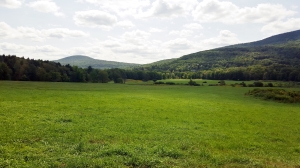
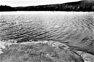
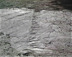
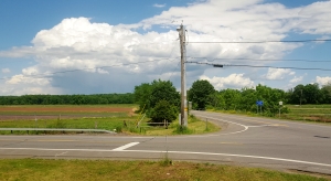
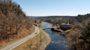
Let’s learn some more this week. We would like you to drive west from Windham on Rte. 23. You may have done this before, perhaps many times. But, as always, we want you to be paying more attention to the landscape that you are passing. We, especially, want you to take heed of the flat landscapes down at the bottom of the valley. It would be easy to dismiss this as a floodplain, after all valley floors are supposed to display floodplains. But, you would be wrong; this flat landscape is the floor of an ice age lake. Lake deposits are almost always spread out as flat sheets. That’s what we see here.

These lake bottom landscapes continue at least as far west as Ashland. They speak to us of a glacial lake. It was a big one, extending at least five miles from the Windham moraine to a bit west of Ashland. Rte. 23 lies on a platform that runs parallel to the old lake. That platform also has an ice age origin. It is composed of sediments that were dropped down the northern valley wall and deposited as a lakeshore deposit called a glacial terrace. That terrace was irresistible to highway engineers when they were making Rte. 23. It lifted the highway up onto a well-drained surface.

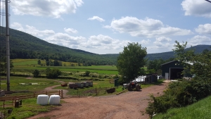
The top of the terraces was deposited at just about the old lake level. Our topographic map tells us that that level was at about 1,500 feet in elevation. The map also tells us that the lake bottom lay at about 1,450 feet. We can thus calculate that the lake was about 50 feet deep. It got a good bit deeper toward Ashland. Turn south (left) at Jewett Heights Road and, when you get down to the river, stop and get out. You are now standing on the floor of a deep lake! Have you ever done that before?

You might do a little exploring. Look for a vantage point, somewhere above the 1,500 foot level. Now you can look down and, in your mind’s eye, you can survey Glacial Lake Windham as it once was. We picked a day, very late in the Ice Age. The climate had been warming up considerably and the ice had melted off most of the lake’s surface. There was, however, still a narrow shelf of gray ice all around the lake’s shore.

We were hoping to see some animals. Perhaps a mastodon or two might have been walking the shores of the lake. But, we were disappointed. It was not that late in the Ice Age, it was still too cold in Windham.

Contact the authors at randjtitus@prodigy.net. Join their facebook page “The Catskill Geologist.” Read their blog “thecatskillgeologist.com.”

Glacial Lake Windham – Apr. 27, 2023

in Uncategorized by


The Ice Age at Windham – Part one, an introduction

The Catskill Geologists; The Mountain Eagle; Sept. 1, 2017

Robert and Johanna Titus


We understand that we have a number of new readers in the town of Windham, and we are glad about that (Sept. 2017). Let’s begin today a series of articles about the ice age history of that town. We can start at the relatively new Windham Path, located in the Batavia Kill Valley about a half mile east of town. It was opened about four years ago and offers some pleasant and easy walking.

Take a look at our photo. Most people see an inviting place for recreation; naturally we see geological history. Our photo was taken from the path’s parking lot. If you go there we would like you to look straight ahead into the distance. Notice the broad flat surface on the distant right of our photo. Now take a look to the left. Our picture shows a low tree-covered hillock spread out east of those flats.

Most people just see landscape; let’s learn what the two of us see. That hillock on the left is what geologists call a moraine. That’s a heap of earth that was brought to where you find it by an advancing glacier. We look at it and, in our mind’s eyes, we see a glacier advancing from the right. It was advancing because the climate had been getting colder – cold is good for glaciers, right? But by the time our glacier reached the left side of this view, climate change had begun; it started warming up and the glacier began melting away – retreating to the right.

During its advance, that glacier had been bulldozing large amounts of earth, all of it piled up at the front of the ice. But, when the glacier was melting away, all that earth came to be left behind. That’s a moraine; this heap of earth speaks to the two of us of an important chapter in the ice age history of Windham.

What happened next? The retreating glacier was backing down the Batavia Kill Valley. It acted as a dam and that formed a glacial lake, lying between the retreating ice and the moraine. It’s the sediments of that lake that make up that flat lying surface in the distant right.

You might go there and do what we do. We always keep a barbeque skewer in the back of the car. We bring it down to flat surfaces like this one, and try to drive it into the ground. If, as we expect, we have found a lake deposit then the skewer will easily slide into the ground. If it doesn’t, it has hit a rock and it is not a lake deposit. Lake sediments are all silt and clay and don’t have rocks in them.

Well, we have seen the Windham Path as most people don’t. We gaze at it and we see an ice age landscape; we form visions of what it was like here at the close of the Ice Age. It can be an exhilarating experience.

But it is important to take this information and use it to form a broader picture of ice age history in the Batavia Kill Valley. Let’s get back in our car and head west on Rte. 23. We notice, right away, that we are crossing an elevated landscape with rolling and sinuous hillocks. This landscape continues until just past Mitchell Hollow road at the eastern end of the Windham business district. We have found another moraine and this one is a bigger one. Like the one at the Windham Path it speaks to us of a glacier advancing east through the Batavia Kill of long ago.

We have learned a lot about Windham, but we have a lot more ahead of us.

Contact the authors at randjtitus@prodigy.net. Join their facebook page “The Catskill Geologist” and read their blog at thecatskillgeologist.com.

Geology at Windham Pt One

in Uncategorized by

The Ice Age at Windham – Part one, an introduction

The Catskill Geologists; The Mountain Eagle; Sep. 8, 2017

Robert and Johanna Titus


We understand that we have a number of new readers in the town of Windham and we are glad about that. Let’s begin today a series of articles about the ice age history of that town. We can start at the relatively new Windham Path, located in the Batavia Kill Valley about a half mile east of town. It was opened about four years ago and offers some pleasant and easy walking.

Take a look at our photo. Most people see an inviting place for recreation; naturally we see geological history. Our photo was taken from the path’s parking lot. If you go there we would like you to look straight ahead into the distance. Notice the broad flat surface on the distant right of our photo. Now take a look to the left. Our picture shows a low tree-covered hillock spread out east of those flats.

Most people just see landscape; let’s learn what the two of us see. That hillock on the left is what geologists call a moraine. That’s a heap of earth that was brought to where you find it by an advancing glacier. We look at it and, in our mind’s eyes, we see a glacier advancing from the right. It is advancing because the climate had been getting colder – cold is good for glaciers, right? But by the time our glacier reached the left side of this view, climate change had begun; it started warming up and the glacier began melting away – retreating to the left.

During its advance, that glacier had been bulldozing large amounts of earth, all of it piled up at the front of the ice. But, when the glacier was melting away, all that earth came to be left behind. That’s a moraine; this heap of earth speaks to the two of us of an important chapter in the ice age history of Windham.

What happened next? The retreating glacier was backing down the Batavia Kill Valley. It acted as a dam and that formed a glacial lake, lying between the retreating ice and the moraine. It’s the sediments of that lake that make up that flat lying surface in the distant right.

You might go there and do what we do. We always keep a barbeque skewer in the back of the car. We bring it down to flat surfaces like this one, and try to drive it into the ground. If, as we expect, we have found a lake deposit then the skewer will easily slide into the ground. If it doesn’t, it has hit a rock and it is not a lake deposit. Lake sediments are all silt and clay and don’t have rocks in them.

Well, we have seen the Windham Path as most people don’t. We gaze at it and we see an ice age landscape; we form visions of what it was like here at the close of the Ice Age. It can be an exhilarating experience.

But it is important to take this information and use it to form a broader picture of ice age history in the Batavia Kill Valley. Let’s get back in our car and head west on Rte. 23. We notice, right away, that we are crossing an elevated landscape with rolling and sinuous hillocks. This landscape continues until just past Mitchell Hollow road at the eastern end of the Windham business district. We have found another moraine and this one is a bigger one. Like the one at the Windham Path it speaks to us of a glacier advancing east through the Batavia Kill of long ago.

We have learned a lot about Windham, but we have a lot more ahead of us.

Contact the authors at randjtitus@prodigy.net. Join their facebook page “The Catskill Geologist” and read their blog at thecatskillgeologist.com.

New Overlook at Kaaterskill Falls – April 4, 2023

in Uncategorized by

The New Kaaterskill Falls Overlook

The Catskill Geologists, The Mountain Eagle, Aug. 17, 2017

Robert and Johanna Titus


Have you been to Kaaterskill Falls lately? People have been visiting there for two centuries. We have seen initials carved into the rock there dating back to 1810. It was probably landscape artist Thomas Cole who first made it famous with his paintings, done in the 1820’s. It’s scenic but, it is a dangerous place; many people have died there.

Something needed to be done. Work began in recent years. The whole trail system, approaching the falls from downstream, has been refitted. But our focus today is on the new trail to the upper falls. You get there by taking Rte. 23A east to Haines Falls. Then you turn left onto County Route 18 and continue east. Turn right onto Laurel House Road and drive to the end. If you have been there in the past you will be pleasantly surprised by the new parking lot. You will have no trouble finding the new trail. It’s right there. It is paved and winds back and forth through the woods in a fashion that allows it to have nothing more than a gentle slope, making it all the more accessible for the elderly and probably even for those on modern powered wheel chairs.

When you get to the end of the trail you will find a fine viewing platform with sturdy guard rails. The bars are high enough to provide safety and thin enough so that they do not block the view. And what a view it is. They were careful to select just the right spot for this platform.  You look down and see all of the upper falls. Our photo could not do justice to this view; you will just have to go there yourself. You can scan sideways and see, off in the distance, High Peak and Roundtop Mountains. It is a much better view than could ever have been seen in the past.

And we are sure that it will be a lot safer than the old trail, the one that went to the top of the falls. Nobody is likely to want to climb over the bars here, so it is far less probable that there will be so many accidental deaths. If you insist, you can find the old trail and you can go and visit the top of the falls, as in the past. But they have made that trail unobtrusive and we are guessing that there will be much less traffic in that direction. That will only allow limited numbers of people going where the dangers are greatest.

   There must be some good geology here or we would never have paid much attention to the place. There is. Take a good look at our photo. There are three massive ledges of Catskill sandstone, commonly called bluestone. One is at the top, or the lip of the falls, and the second is halfway down and hard to see. The third makes up the platform at the bottom of this, the upper falls. All this belongs to a unit of rock called the Oneonta Formation, a late Devonian aged rock formation that can be traced all across the upper Catskills. It is part of the fabled Catskill Delta. Those sandstones are ancient river deposits. Those ledges were once sands, and that sand filled the channels of rivers that crossed the old Catskill Delta.

In between those sandstones are thicknesses of brick red shales. These comprise more of the Catskill Delta. They formed, originally as overbank deposits. That is, they formed as floodplain deposits in between the old river channels. So, altogether, the strata of Kaaterskill Falls constitute a very representative cross section of the Catskill Delta.

Make sure you go there soon. We applaud what has been done at Kaaterskill Falls. Two thumbs up!

Contact the authors at randjtitus@prodigy.net. Join their facebook page “The Catskill Geologist.” Read their blog at thecatskillgeologist.com

Time lines in the Schoharie Valley – 4-6-23

in Uncategorized by

Time lines

The Catskill Geologists

Robert and Johanna Titus

The Mountain Eagle 2017


Late at night in geology bars, we geologists ponder deep thoughts about what geologists call “deep time.” We would like to relate some of those thoughts to you in this week’s column. It’s an account of what we visualize when we drive south a few miles from Middleburgh on Rte. 30.

Any time of the year this is a scenic drive. Left and right, we pass beautiful agricultural fields. This is a remarkably flat landscape and much of it is fertile land; it has been farmed for centuries and all farmland is pretty. Then there are several scenic hamlets, including Fultonham and Breakabeen. We like to sometimes stop at the farmer’s markets along the way. This is the modern world that we are traveling through, and Rte. 30 provides a very nice view of it. When autumn is coming up; you should take this drive.


But, we are geologists, and we are always finding ourselves in the distant past. Did you read our recent column about this area? Then you know some of what we see when we do this drive. We related how this stretch of the Schoharie Creek Valley was once the bottom of an ice age lake. That was, perhaps 14,000 years ago when the ice age climate was warming up and the glaciers were melting away. We learned that this lake was hundreds of feet deep back then. If Rte. 30 had passed across that lake bottom then it would have been a pitch black road.

The next time you are there, stop and take a look around. We like to say that we are able to “savor” time at places like this. This broad flat valley floor has two manifestations in time. It is the world we see and that same flat surface was also the bottom of a substantial lake. This flat landscape has led at least two lives. You can imagine the thoughts this generates in a geology bar.

But, there is actually a lot more. When you explore the area, here and there you will encounter stratified bedrock. These exposures are mostly sandstones and shales, and it is not unusual for them to be rich in the fossils of marine shellfish. There are some substantial outcrops. One is at Vroman’s Nose. The next time you climb that “nose” watch for outcrops of stratified rock along the way. Drive south again and watch for more exposures along the way. It’s the same thing; those strata are frequently rich in fossils.  Each stratum was formed on the bottom of a sea. It gets better; each stratum was the bottom of a sea.

Perhaps you are getting the drift of today’s column; we have been describing a single flat surface that extends south from Middleburgh. It is a surface that exists today and, in this form, it is a very scenic location. But there is so much more. This surface has existed several times in the distant past. It was, 14,000 years ago, the bottom of an ice age lake. It was just as flat then but under hundreds of feet of glacial meltwater.

Then there was that third time our surface existed. About 380 million years ago it was the bottom of a saltwater sea. Geologists call landscapes like this “exhumed.” As such they are landscapes that reveal episodes of time from the very distant.

We hope you will enjoy this ride in the country during the coming leaf season. Pull over, get out of your car and “savor” our geological history.

Contact the authors at randjtitus@prodigy.net. Join their facebook page “The Catskill Geologist.”

A fossil Stream in Woodstock. Mar. 30, 2023

in Uncategorized by

A Fossil River Runs Through Woodstock

On The Rocks, The Woodstock Times

Updated by Robert and Johanna Titus


There is one very good thing about geology – you don’t have to travel very far to go see it. That’s certainly the case here in Woodstock. As we drove into town of Woodstock one day we stopped and took a long look at the rock outcropping at the intersection of Rt. 212 and Chestnut Hill Road. That’s just east of town. The rocks there belong to a unit called the Kiskatom Sandstone. They were deposited long ago as sediments on the outer edge of the great Catskill delta complex. Once again, the rocks took us back to a Devonian age Woodstock, maybe 380 million years ago.

We knew the images that these rocks would generate in our imaginations. We could look east and, in our mind’s eye, we could see the towering profile of the old Acadian Mountains rising on that horizon. The Catskill delta lay below the mountains. It was an enormous expanse of fast-flowing and sluggish streams, with swamps, bayous, lakes and ponds. Here and there, we could see dense but primitive foliage’s of primitive plants. This was the setting in which the rocks of Woodstock had first accumulated as sediments.

All this was vague imagination, but an outcrop is made up of real rocks and real rocks usually have very specific and often very interesting stories to tell. Here, at the Chestnut Hill intersection, there were two types of lithologies and two stories. The most striking rocks were the massive sandstones that made up the upper half of the exposure. Sandstones are just what they sound like, masses of cemented sand. These sands were deposited in strata which were inclined, first one way and then another. The sets of strata intersect each other in a pattern called “cross bedding.” From plenty of experience we knew what this meant. We were looking at sediments that had been deposited in one of those old delta rivers. The cross bedding formed as the sands were buffeted back and forth by changing currents associated with the rising and falling of the river’s flow. Each set of strata recorded an everyday moment in the history of that nameless old stream.


The finer grain deposits below the sandstones were different. They were more thinly laminated and composed mostly of silt and clay, now hardened into shale. Its color caught our attention, the shales were reddish. That’s a common color for rocks throughout the Catskills. This soft, brick-red is an indicator of terrestrial conditions, the shales had not been deposited in a river, but they had been the soils that formed on the banks and in between the streams.

When you go there, you will notice that there is a sharp boundary between the channel sandstones and the red soils. That’s not unusual, after all, rivers get to where they are by eroding through the surrounding countryside. This old river had cut its way through the Devonian flood plain soils.

There are ironies in the study of ancient rocks. We were acutely aware that the old river occupied the very space where the Saw Kill is today. Woodstock, then and now, was flood plain. There’s no relationship between the two rivers. They each occupied the same space, but they existed nearly 400 million years apart in time. Because of its age the old river may seem like an abstraction, or somehow less real than today’s Saw Kill. It’s not, in its time it was just as real as the Saw Kill is today. And 400 million years from now, both of them will be equally lost in time. That’s just the way it is. We, all of us, play out our roles on this planet and then disappear into time.

Contact the authors at randjtitus@prodigy.net. Join their facebook page “The Catskill Geologist.”

Alien visitors at site 151 Mar. 23, 2023

in Uncategorized by

Alien visitors at Site 151

On the Rocks

The Woodstock Times

Robert and Johanna Titus


We have written so many columns about the North Lake area. We just never seem to run out of topics and we continue to find new ones all the time. There is a reason for that; North Lake (and South Lake too) is a geological wonderland. Have you been there? It’s time! You take Rte. 23A and drive up Kaaterskill Clove. That’s an adventure all by itself. You watch for the right turn that takes you onto County. Rte. 18 which is also known as the North/South Lake Road. You follow the road until you enter the park and proceed onward until you get to the North Lake parking lot.

Now comes the hard part; you have to walk down to the shore of North Lake and head north. You want to enter into the campground and you, specifically, want to locate campsite 151. We can’t offer much advice about that, but we did it so you can too.  Along the way, we want you to be looking at the bedrock exposures. There are a lot of good ones right along the edge of the lake. It won’t be hard to notice that there are a lot of long straight scratches in the rock surfaces.

If you have been a long time reader then you know what we are talking about. These are glacial striations. They were etched into the rocks more than 14,000 years ago, near the end of the Ice Age. What happened was that a glacier flowed by. It was dragging a large amount of sand with it, and that sand acted like the sand of sandpaper. It was scraped against the bedrock and that gave those surfaces a smooth polished look. Then, the moving ice brought pebbles and even cobbles along. Those dragged bottom and did the etching; those striations were the results.

You learn a lot more by measuring the compass directions of those striations. Most all of them are aligned with a southwest orientation. They speak to us of a mass of ice moving in the direction of South Lake. The ice had risen up out of the Hudson Valley and moved, ever so gradually, to the Northwest. Along the way, it had polished and striated the rock. Take a look at our first photo. The striations are seen in the shoreline rocks. All of them are aimed at the distant location of South Lake.

It did something else; it scoured out North Lake itself. The lake’s basin is a direct product of the movement of this glacier at that time. This has been known to geologists for a very long time. We wonder who the first geologist to recognize this was. We don’t know; that discovery has been lost to history. What a moment it must have been. In a flash, some expert and observant geologist had figured out the very origins of North Lake. And that person had discovered a very good story to tell. The lake’s basin had been scoured out by an advancing glacier.

Well, we think we have a story to tell that is nearly as good. Remember site 151? Let’s go back and find it. That campsite has an expansive stretch of exposed bedrock abutting it. It’s a broad platform of flat rock, perhaps a quarter acre in size. That’s big for an outcropping and it is also quite flat. There are reasons for this.

This fine exposure is a product of the same ice that carved those striations along the lakeshore. It was that moving ice that had bulldozed the landscape here to expose all that rock. It was that glacier that had beveled the rock down to make it so flat. And there is more; there are some very fine striations exposed here. Back during the Ice Age, Site 151 had received some alien visitors; they were glaciers which had originated all the way north, as far as Labrador.

And there was more than just one set of visitors. There is a second set of markings on these rocks. Take a look at our second photo. It’s the site 151 bedrock. You will see a number of striations and those are all oriented going away from our viewpoint. But there is a second set of markings; they are a series of crescent shaped fractures that cross the striations at an angle of about 30 degrees. That’s from the lower right to the upper left. These are most commonly called crescent marks. They record a younger glaciation. A younger mass of ice was crossing over the same outcropping, but this one was advancing at a different compass direction.

These crescents record that this glacier was carrying a boulder within it. The weight of the ice tried to hold the boulder down, but the shove from behind tried to advance it. Something had to give, and when the shove from behind was great enough, the boulder leaped forward and impacted the rock. Each leap forward created one crescent in the series that we see in the photo.

That quarter acre of exposed rock records two episodes of advancing ice – two glaciers, one after the other. That’s history – ice age history.

Contact the authors at randjtitus@prodigy.net. Join their facebook page “The Catskill Geologist.” Read their blog at “thecatskillgeologist.”

A Drive Around a Glacial Lake Mar. 17, 2023

in Uncategorized by

Driving Around a Lake

On the Rocks; The Woodstock Times; June 16, 2016

Robert and Johanna Titus


We frequently meet people who read our columns and then go out and see for themselves what we have been writing about. One couple told us that they keep some of our books in the glove compartment of their car. They like to go exploring for what we have written. We are always glad to get that sort of feedback. So – let’s take you out, this week, and go see some fine geology. It will be a visit to a glacial lake. Don’t worry; you won’t get wet; the lake emptied many thousands of years ago.

We started our journey when we pulled off the road at the intersection of Routes 23A and 32 near Palenville. We gazed westward and spent a little time looking at the lower reaches of Kaaterskill Clove. We imagined the clove at various times during and at the end of the Ice Age. Today’s scenery can generate some vivid images of the past. First, we looked north and watched as the Hudson Valley glacier as it advanced down the valley, closing in on us. Then a branch of that glacier peeled off to the west and rose up the clove. As geologists we are patient folk; we watched as the same ice melted away and enormous amounts of meltwater cascaded down the canyon.  We had seen nothing less than the origins of Kaaterskill Clove. How fortunate we are. But there was more.

Then we turned around and saw some more images from the ice age past. Let’s go exploring that past. At first, it didn’t seem like there was much to see, just a dull, broad, flat field. But that flat field before us was an old lake bottom, called Glacial Lake Kiskatom. If you care to, you can take a shovel, walk into that field and drive the shovel blade into the ground. You will easily turn over a shovel full of sandy silt. There are very few cobbles in it, not many pebbles either. This is the mud of an old lake bottom and lakes do not accumulate cobbles or pebbles, just silt and clay.

We got our map out and looked at it carefully. To the south, the flat lands of the lake bottom extended about a quarter of a mile; they reached more than two miles to the north. As far as we could see all was flat. We drove east and turned left on Ramsey School Road, named for the old one room schoolhouse that used to operate there. Now we were driving north along the east shores of the old lake. We looked to the west and, again, saw its waters spread out before us. We continued north and the road became Paul Saxe Road. Soon, to our right, there was an old embayment of Lake Kiskatom, but then the road climbed back up onto the eastern shore of the lake.

Before long, we turned left onto Cauterskill Road and that took us across the lake bottom toward its western shore. There is something exhilarating about being on the bottom of an ancient lake. We stopped and got out. We looked up and “saw” the waves passing above. They glistened, gleamed and sparkled as they caught the sunlight. To the north the lake bottom was very wet. This was still wetland; it just had never properly drained. The maps call this part of the lake bottom “Kiskatom Flats.”

We rejoined Rte. 32 at Hearts Content Road. We looked up that road and saw that it followed the north shore of another embayment of the lake. We pulled over and looked at the embayment and saw it filled with water. What a wonder it is for geologists to look at a landscape and see its geological heritage. Privilege might be an even better word.

Next, we were heading south on Rte. 32 with the waters of the lake to our left. We passed Rte. 23A and went another quarter mile. We turned left onto High Falls Road. We traveled about three miles through a very picturesque neighborhood with many fine old homes. Kaaterskill Creek was always just a short distance to our left. It had carved something that could not be called a canyon but was an awfully narrow valley.

Our goal was High Falls itself. The property here is all sorts of “no trespassing” but the road does take you, legally, across the top of the falls. Kaaterskill Creek, during millennia of erosion has cut a canyon into the bedrock here. You can stop and walk out onto the bridge and see the top of the falls. An enormous flow of meltwater once passed this way. Notice the abundant straight fractures in the rock; these are called joints.


What we were looking at, and what we had been driving past, was the ancient outlet of Lake Kiskatom. All lakes have to have some sort of an exit, a stream that drains their waters. Kaaterskill Creek had served that purpose long ago. During the great melt that accompanied the end of the Ice Age, Kaaterskill Creek must have been a torrential and erosive flow of water. The narrow valley we see here, reflects that heritage. Kaaterskill Creek, eventually, leads its waters toward the Hudson.

We had now finished our exploring. We had recognized an ice age lake and driven around it. We hope that you get a chance to do this drive too.  See if it does not give you a whole new perspective on what a person can perceive when they know how to look not just at, but also into a landscape. We do it all the time; you can join us.

Contact the authors at randjtitus@prodigy.net. Join their facebook page “The Catskill Geologist. Everybody else has!


A Devonian Predator – March 2, 2023

in Uncategorized by

Plants and animals and cobbles in a Bearsville quarry

On the Rocks; The Woodstock Times; Aug. 12, 2017

Robert and Johanna Titus


We often look up into the hills above us and wonder what’s up there. We just can’t go everywhere; we can’t explore all the high slopes and mountaintops in all the Catskills. That’s beyond a lifetime of exploration. But, we can’t help it if we wonder what we are missing. Recently we got a chance to find out just a little about what is up there. We heard from Meryl Hyatt, a summer resident of Bearsville. She and her husband Steve have a home on a hill north of Rte. 212. Their property includes a pair of old bluestone quarries and they had found some fossils in those strata. Could we come and take a look. Well, one of us, Robert, did just that.

Upon arrival, a host of Hyatt family and family friends were waiting in greeting. We are sometimes surprised to find out just how many readers we have. They described a steep hike up the hill, but first they had a pile of fossils that needed to be identified. We always enjoy that; it’s our version of “Antiques Road Show.” The prize specimen was a fine fossil Devonian Catskill plant. It was a form that is well known here in the Catskills; it is called Archeopteris (Not to be confused with the Jurassic bird Archaeopteryx.) It had been collected in one of the quarries we were set to explore.

Soon we were off; our climb took a while and it was steep, but we did get there. Our topographic map told us we had ascended 500 feet. The two quarries were at the same level and located near to each other. It was obvious right from the start, that these had once been two very high quality bluestone quarries. The strata were relatively flat-lying and thin-bedded. These rocks must have been easily split into sidewalk slabs and that is what bluestone quarrying was mostly about.  We were having fun, but we could not help but to think about all the backbreaking hard work that had been done here a century ago.

Strata of this sort were mostly deposited in the middles of large Devonian age rivers, the very rivers that crossed the old Catskill Delta, perhaps 380 million years ago. If you have been a frequent reader then you know that the Catskill Mountains are an enormous petrified delta complex. They comprise a lithified landscape called the Catskill Delta. These two quarries were representative samples of that delta.

Such thinly laminated strata speak of relatively fast flowing river currents. Our group had been transported to the middle of a very large and very wide river and we were all being swept along by its powerful currents. Then, suddenly we found hard evidence for that interpretation. We found a two inch cobble in the midst of the river sandstones. It had been nicely rounded during its journey down the river. This was nature’s lapidary work. Think about how strong the currents must have been to roll along a cobble of this size. It was an unusual find; things like this are rare in the Catskills.

We continued our mind’s eye journey. We “swam to shore” and found the Devonian river banks lined with Devonian trees. Those were all of the genus Archeopteris. The trunks leaned over the waters and the foliage at the top was composed of dense leaves. It did not, in any way, look like anything is the forest of today’s Catskills. These Devonian trees are called progymnosperms; they were early ancestors of today’s conifers and evergreens.

We poked along the quarry walls. Then we looked up and saw what appeared to be evidence of some of the animals who had long ago, lived in our stream. They had left markings on the sands of the river channel (see our first photo). Those had hardened into rock. We had no idea what kinds of animals they might have been but we could see that they had been poking about on the floor of the river channel. We guessed that, all those 380 million years ago, these animals had been searching for something to eat in the river sands. We surmised they had been some sort of carnivores. But we could not be sure. Those poking marks are called trace fossils, they record brief moments of activity in the lives of ancient organisms. We can never be absolutely sure what those creatures had been up to, but they must have been searching for something.

Then we made the prize find of the day. Take a look at our 2nd photo. It is simply an especially good example of what we had been seeing. We are going to give you our interpretation of what we think happened so long ago. It is guesswork, but informed guesswork. It comes with no guarantees. Our animal, it would seem, had been swimming through the water sniffing for food. It was attracted to something in the river sands. It descended and “came to earth.” Then it startled poking. We have numbered the pokes in the order that we think they were made. This was just the sort of things we were hoping for; it was a tantalizing find.

Pokes one through six were searching marks, or so it seemed. Our predator was getting itself closer and closer to what it was searching for. Then poke seven was the final stab. We are betting that this creature made its catch. I had won its meal.

You can never be sure of yourself when you are making speculations of this sort. We will never know what really happened at this location on that day so long ago. But we were privileged to take a glimpse into the past and that was good enough.

Contact the authors at randjtitus@prodigy.net. Join their facebook page “The Catskill Geologist.


The Rosendale Trestle – Feb. 23, 2023

in Uncategorized by

The Rosendale Trestle

On the Rocks, The Woodstock Times; May. 16, 2016

Robert and Johanna Titus


Have you been down to the newly restored trestle at Rosendale? It’s just another one of those really good ideas that turns up from time to time. You have, quite possibly, been on the walkway that crosses the river at Poughkeepsie. That’s the old railroad bridge that was refit for foot traffic. Now it is a grand tourist attraction. That walkway takes you on an almost breathtaking crossing of the Hudson. Well they did pretty much the same thing at Rosendale, just on a much smaller scale. You have to go and see it!

This had once been an active railroad trestle that crossed the Rondout Creek at Rosendale. That was in the late nineteenth century. Rosendale had, back then, been one of our region’s real industrial centers. It manufactured very large amounts of natural or “Rosendale” cement. They must have needed a railroad and they did have one. That railroad connected New Paltz with Kingston. We rather suspect that stops were made to pick up cement. Both the natural cement industry and the railroads are now just long-ago memories. The railroad closed in 1977, but the trestle survived. It towers 150 feet above the Rondout Creek and it is more than 900 feet long. For a brief time it served as a professional bungee jumping site, but that did not last. It needed to be restored so it could be opened up for foot traffic, and that did happen. The new foot traffic trestle is the centerpiece of the 22 mile long Wallkill Valley Rail Trail. It opened in 2013.

We kept meaning to visit the trestle and we kept putting it off, but finally we did go. It was well worth the trip. To get there take State Rte. 213 through Rosendale and head west. You will pass beneath the trestle. Watch for Binnewater Road, turn right and then left into the kiln parking lot. From there you have access to the rail trail that will take you for the short walk to the trestle. That parking lot is worth the trip by itself; there are a large number of old industrial lime kilns that date back to the natural cement days.

Well, we worked our way up the trail and soon found ourselves out on the trestle.
Take a look at our photo to see the view; it is a good one. We, of course, enjoyed the scenery but we were soon dreaming geological thoughts about the landscape before us. Right here, the Rondout Creek passes through something that just falls a little bit short of being a genuine, authentic canyon. The slopes on each side of the river rise quickly and steeply. How did this happen?


We had some research to do. But, fortunately, we already knew most of the basics; we had worked this area before. We knew that the Rondout Valley has had a rich ice age history. Back in time, late in the Ice Age, there had been one final advance of the ice. A valley glacier, a single large stream of ice, had advanced up the Rondout Valley. We are not sure how far it got, but it must have actually approached Port Jervis. Then the climate warmed and the ice began to melt away. That caused a retreat, actually a melting back of the glacier. For a substantial period of time the remaining ice dammed the valley and that caused the formation of a glacial lake called Lake Wawarsing.

Someday, perhaps you will find yourself driving southwest on Rte. 209. After passing Ellenville, you will begin to see a broad flat valley floor. That’s the bottom of Glacial Lake Wawarsing. You will see that it was a big lake and it all lay upstream from Rosendale. Well, we knew every bit of this when we were standing on the trestle. That knowledge was our passport into the past.

The two of us walked to the east side of the trestle and looked that way. We saw the ice coming toward us. The glacier passed us and continued on to the west. Next we walked to the western side of the trestle. It was about 1,000 years or so, later. The ice, that had clogged the valley in that direction, was in the process of melting away. It might be better described as disintegrating. Climate change was in full force. Vast, enormous volumes of meltwater had been liberated by the warming. And all that water was headed toward us. We were the mind’s eye, the human imagination, and we were standing upon an imaginary trestle at a very real moment in time, an important one.

Raging, foaming, pounding masses of whitewater cascaded by, just beneath us. What an image we saw; this was the very day when more volumes of water would pass by than ever had before or ever would again. This was the very moment in time when the Rosendale canyon was taking shape. What was going on just beneath us was extremely erosive.

Off to the west, Lake Wawarsing was draining at an almost alarming rate. And all of that water was thundering by beneath us. The power of the moment was unsustainable; all bad things must come to an end. The lake was emptying. We watched as the currents abated. We gazed as the water levels ebbed below the trestle. We saw something of a normal flow being restored.

We were absolutely thunderstruck by what we had witnessed. We had long understood this sort of thing, but to actually see it is something altogether different. What a gift it is to be geologists; we get to travel to beautiful places but we get to see them as others do not.

Contact the authors at randjtitus@prodigy.net. Join their facebook page “The Catskill Geologist.” Everybody else has.

1 4 5 6 7 8 41
Go to Top