"I will never kick a rock"

Author

Robert Titus - page 16

Robert Titus has 406 articles published.

The old mountain turnpike Ar. 29, 2021

in Uncategorized by

The Old Mountain Turnpike

On the Rocks – The Woodstock Times

Updated by Robert and Johanna Titus


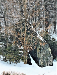
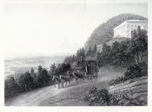
One of our region’s most historic roads is also one of its least known. It’s the Old Mountain Turnpike. Long ago, the road was the gateway to the Catskills. As far back as the 1820’s guests of the famed Catskill Mountain House Hotel took carriages up the pike to get to the hotel. As the hotel prospered, so did the turnpike. When the hotel got even more successful, it built the Otis Elevated Railway right up the Catskill Front, and the old dirt road slowly fell into disuse. Today the once great turnpike is just a horse and hiking trail, but it still has much of its 19th Century atmosphere. It makes a nice walk in the woods and, of course, along the way there are many rocks.

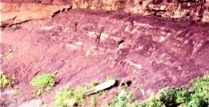
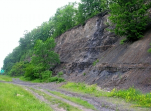
To get to the Old Mountain Turnpike take Rte. 23A into Palenville. Turn onto Bogart Road and head north to Mountain Turnpike Road where you turn left, the trailhead is at the western end of the road. You can hike all the way up to North Lake State Park if you like, or any part of the way. You don’t have to go far however before you are in the thick of the geology. The road climbs, makes a bend, and then a fine outcropping of reddish rocks appears. This is great Catskill Delta of the Devonian age. Such red strata are old floodplain deposits, silts and clays left by ancient floods and hardened into red shales. The darker deposits are the muds of delta backswamps. Away from the river channels, swamps formed in low-lying areas and those dark muds accumulated. Watch for fossil plant fragments in all of this.

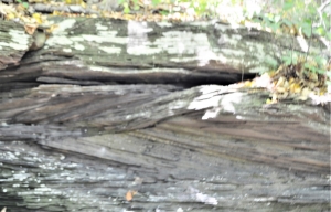
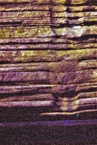
As you continue up the road you will encounter, at frequent intervals, a number of sandstone ledges. They are Devonian river channel deposits, composed mostly of sandy strata that dip one way or another. These are called cross beds and they are the products of ancient river currents. The river currents drove masses of sand into large “dunes” which migrated downstream. Most of those cross beds dip to the northwest as that was the direction that the old rivers flowed. In between the sandstone ledges the road tends to be pink or red. These are hidden floodplain deposits. The pattern is clear: river sands are followed by red floodplain shales and then more river sands and so on. The Catskill Front is like a great building, it’s made up of sandstone and shale “stories.” When we make such a hike, we almost always count those stories.

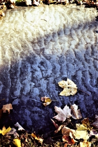
The second story had some prominent ripple marks in a layer of red shale that crossed the road. The ripples record breezes that blew across a shallow delta pond and generated currents that, in turn, created the ripples. Incredibly those ripples are the record of breezes of nearly 400 million years ago.

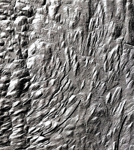
At the fourth story we found a vertical ledge of sandstone that had been scoured and striated by a passing glacier. This event occurred a mere 20,000 years ago. A twinkling of time compared to the age of the rocks themselves.


The 14th story was a massive sandstone. This must have been a very large river. Such rivers were what are called delta distributaries. In a large delta complex the trunk stream splits up into many such distributaries. Each one meanders back and forth across the delta plain. A river that is here today, may be gone tomorrow, replaced by a floodplain. That’s why these river sandstones alternate with red floodplain shales. Look at a map of the Mississippi Delta and you will see good examples of such distributaries. Then look at a map of the Ganges River Delta of Bangladesh and you will see even better examples.


The road ascended into a place called Sleepy Hollow and then made a sharp left bend. Here had once stood the Rip Van Winkle House; it had been the halfway stop for carriages headed up to the hotel. The hollow was naturally air conditioned with cool mountain breezed descending through it. It must have been a nice place to stop. But what impressed us most was just above, one of the largest, thickest stories of the hike. We thought that this must have been one of the greatest rivers of the Catskill Delta.

The 24th story brought us to a great overlook. The trees have been cleared away here and a picnic table set up. We ended our journey and sat and gazed out at the Hudson Valley. We had seen enough history for one day. We had watched as 24 Devonian rivers and one glacier had crossed this location. History is complex.


Contact the authors at randjtitus@prodigy.net. Join their facebook page “The Catskill


Geologist.”

The Claverack Giant Apr. 22, 2021

in Uncategorized by

The Claverack Giant

The Columbia County Independent

Dec. 20, 2002

Updated by Robert and Johanna Titus

IN RECENT DECADES there has been a small flurry of discoveries of ice age elephants in New York State. You may well have read about the mastodont discovered in Hyde Park; it made quite a stir down there. The bones were found quite by accident in a swampy section of family’s backyard. All they had wanted was to dig a small pond, what they got was an ice age treasure. Researchers from the Paleontological Research Association in Ithaca spent the summer excavating the skeleton and most of it was recovered. Such events are very exciting, and people come from all over to see the bones as they emerge from the muds. Some even got involved in the project, there is never a shortage of local volunteers to help out in such a dig.

Less well known was a similar discovery near Ithaca. Another swampy area yielded the bones of an ice age elephant. This one was a woolly mammoth, and this dig attracted dozens of Cornell students. A big surprise awaited them when, during the excavation, the remains of a second skeleton, this one being another mastodon, came to light. You can imagine the excitement that accompanied this “twofer.”

Such discoveries are always big news stories in the local area. They should be; they are rare and exciting events. But, during the eighteenth and nineteenth centuries very many more such discoveries were made. In those times it was common for farmers to drain their swamplands and this frequently led to the discovery of large bones. The Hudson Valley of New York State became something of a world capital for mastodonts, as these close relatives of the modern elephants were apparently very common here, especially in Orange County in the lower Hudson Valley.

Our story begins in Columbia County. Columbia County is the site of the first discovery of that ice age emblem, the mastodon. This historic event dates back all the way to the year 1705 when a Dutch colonist came across a fossil tooth on the banks of the Hudson River at the town of Claverack, just north of the city of Hudson. The name of our discoverer seems to have been lost to history. It’s a shame as this was, without doubt, the most historic thing that he ever did. The tooth certainly was remarkable. Most of the root had decayed away but the enamel still gleamed. And it was big, weighing in at 4 and three quarters lbs. Evidently, our colonial discoverer thought little enough of it however, as he sold the tooth to assemblyman Peter Van Bruggen for a gill of rum. Van Bruggen brought the tooth to Albany where Edward Hyde, Viscount of Cornbury and governor of the New York Colony, obtained it. Cornbury is most famous for supposedly dressing in women’s clothing, but that is another story altogether. He showed a more scientific side to his nature with his interest in the tooth; he wondered what exactly it represented.

Cornbury wouldn’t keep the specimen to himself; he sent it off to England’s foremost scientific organization, the Royal Society in London. In the letter he sent with it Cornbury reflected upon the various ideas that had been proposed to explain the wondrous fossil. There were two hypotheses: some people thought the tooth to have come from some remarkable beast or fish. Cornbury doubted that; he thought the tooth was human, the remains of an ancient giant.

Cornbury lived long ago in a culture very different from ours. We know what a mastodon is, as we are geologists. You very likely know what a mastodon is as they are very well known to members of our modern culture. All of us are very comfortable with the idea of prehistoric creatures, as we have seen them in the museums, on TV, and in the movies. But, back then nobody, absolutely nobody, had ever even imagined such an animal as a mastodon. Not only had no one ever heard of such a prehistoric monster, but nobody had ever heard of prehistory. That notion would have been quite an unwelcome revelation to Cornbury. He thought, like almost all westerners, that the world was only about six thousand years old, the direct creation, at that time, of God.

So, if there was no prehistory and if there were no prehistoric monsters, then what exactly did Cornbury believe the creature to be? When he used the term “giant” he was referring to the Bible quote “there were giants in those dayes.” To his credit, Cornbury sent men to search the Claverack site for more evidence, and they were successful, sort of. Cornbury’s crew did locate the skeleton and made efforts to dig it up, but the bones were so decayed that they largely disintegrated as the came to the surface. They did estimate the skeleton was 30 feet long. And perhaps, they thought, it had been much bigger than that; a limb bone was found and, before it too disintegrated, it was estimated to have been 17 feet long. A halo of discolored earth surrounded the skeleton, and that was 75 feet long.

Lord Cornbury’s view that this was a biblical giant was enthusiastically embraced by the prominent Puritan minister Cotton Mather, of Witch Trial fame. Mather had once studied to be a physician and had a strong interest in natural history. He, like many ministers of his time, believed that an understanding of nature would confirm the Old Testament account of Earth history. The sediments in which the Claverack giant had been found had been deposited, Mather thought, by the Great Deluge. These views may seem quaint today, but in the 18th century this was legitimate science. The teeth and bones were, Mather argued, the remains of an Antediluvial giant and he wanted to prove that. At that time, he was working on a book to be entitled “Biblia Americana” and in it would be the latest scientific evidence for the Creation and the Deluge. The Claverack giant was important science to Cotton Mather.

But there were other opinions. From the very beginning, in 1705, there were people who had referred to the Claverack teeth as being like the ivory of an “Olivant,” using an old spelling for elephant. The skeleton was not that of a human giant but one of nature’s giants. This was still a very theological view, as the poor creature would have been regarded as having been also a victim of the Deluge. And it must have been quite a flood to have swept a tropical animal so far from its natural setting.

The debate was a long one, and it was not finally settled until a good skeleton turned. Now we have lots of them.


Contact the authors at randjtitus@prodigy.net. Join their facebook page “The Catskill Geologist.” Read their blogs at thecatskillgeologist.com.”

in Uncategorized by

The Killer Trees

On the Rocks/The Woodstock Times, 2000

Updated by Robert and Johanna Titus


Contrary to the stereotype, most scientists have rich imaginations, and we often like to indulge in wild speculations about our fields of research. Most of the time these ideas can be quickly proven wrong, but sometimes we get an off-the-wall idea that is not so easily eliminated, in fact it may start to look pretty good.

Recently (in 2000) an interesting new hypothesis has been introduced that may offer us a chance to better understand the black shales and dark sandstones of the Catskill sequence. The dark appearance of these strata makes them remarkably eye-catching and they loom, dark and menacing, over the landscapes wherever they are exposed. The best local area is along Rt. 209, just south of the Saw Kill.


Black stratified rocks are often rich in undecayed organic matter; it’s the black of the carbon gives these rocks their color. This generally suggests to the geologist that there were low-oxygen conditions in the sea waters at the time of deposition. Without oxygen, most decay bacteria cannot function, and they soon die. But why low oxygen? That’s where that new hypothesis comes in.

That new idea is sometimes called the “killer tree hypothesis.” Although the term may seem a little too extravagant, it probably isn’t that far off the mark. The story starts during the middle Devonian when the evolution of land plants was really starting to accelerate. By then land plants had been around for quite some time, but they had only managed to evolve into small forms with thin, weak stems. Nothing that could be called a tree had yet appeared. Trees require wood as support tissue. Not surprisingly, when wood did evolve, large, tall land plants soon followed, and the world’s first forests quickly appeared.

So what do trees on land have to do with black colored shales in the ocean? Quite a bit, it turns out. Wood had much to do with our story because it allowed trees to grow so tall that they required deep root systems and that’s when we return to the black shale and the poison sea. Complex root systems help to break up bedrock and they greatly accelerate the rate at which bedrock is weathered into soils. Not surprisingly, deep, well developed soils appeared in the Devonian, possibly for first time in history. This was a major transformation of the landscape. Barren landscapes with thin soils were soon replaced by lush foliage and thick soils as our world’s landscapes turned green and blossomed with plants that grew in deep soils.

All of this led to far more rapid rates of deposition in nearby oceans. Thick soils were easily eroded and provided sediments that glutted nearby streams. The sediments were eventually transported into the nearest ocean which was the Catskill Sea. All of this material was rich in dissolved nutrients, materials such as nitrates and phosphates. When these nutrient rich sediments entered the Catskill Sea, they fertilized the water and that led to the next step in what was now a complex chain of events.

The newly fertilized oceans were ideal for algae; they experienced what is called “algal blooms.” Great population explosions of algae occurred in the shallow, surface waters of the Catskill Sea. While all this was great for the algae it was tragic for just about every other category of marine organisms. As the algae died, they were attacked by decay bacteria. The decay process consumed so much oxygen that the seas soon became oxygen-depleted. With the loss of oxygen, bacteria had in effect poisoned their own habitat. Because they needed oxygen too, their numbers soon plummeted and very soon, all types of animals suffocated in the oxygen depleted sea as well. But the algae just kept on proliferating in the surface waters where there was plenty of oxygen, diffusing in from the air. Soon, large masses of undecayed algal material sank to the floor of the ocean. Almost none of this biological matter ever decayed, consequently the sediments that are found there are very rich in black organic carbon. These would eventually harden into thinly laminated, black shales.

When this happens today in a closed body of water, we refer to it as eutrophication. The Catskill Sea was largely isolated from other deep bodies of water.

All of these conditions promoted what are called thermally-stratified and stagnant waters. The surface layer was hot while, at depths, the lower strata of water remained cool. Dense mats of floating plants and animals grew upon the warm surface waters. Depth stratification and a dense planktonic mat prevented agitation and mixing of the waters, causing stagnant sea floor conditions to develop.

Soon a deep basin with a black mud bottom, devoid of life, appeared. Virtually nothing could live in this sea, except at the surface where there was always plenty of oxygen.

   Contact the authors at randjtitus@prodigy.net. Join their facebook page The Catskill Geologist.”

Drumlins along the Hudson April 8, 2021

in Uncategorized by

Drumlins Along the Hudson

On the Rocks – The Woodstock Times

July 23, 1998

Updated by Robert and Johanna Titus


The Hudson River is curious in at least one respect, it doesn’t have a proper floodplain. Much of the Hudson Valley is flat as a floodplain is supposed to be and you can go and see this. Cross the Kingston-Rhinebeck bridge and drive around north of Red Hook. Take Rt. 9 or 9G and you will cover a lot of flat landscape. But it isn’t a floodplain. Floodplains are supposed to be just barely above the level of the river, but this landscape is elevated far above the river, often about 200 feet up. If that flat surface isn’t a floodplain, it must be something else. It’s the floor of Lake Albany, the great lake that flooded the Hudson Valley after the last glaciation. Lake bottoms are composed of flat-lying masses of silt and clay and that is exactly what you are driving across.

But not all of this landscape is perfectly flat. There are a number of hills in the Hudson Valley. Let’s learn about some of them. Take Rte. 103 North of the Bard College Campus and turn right (east) onto Rte. 79. That road will take you into a cluster of small hills which break the smoothness of the old lake bottom. There are nearly a dozen of them and all of them are elongate in a north-south orientation. Most hills are composed of bedrock, but these are mostly sand and gravel with a fair number of boulders mixed in. Most of them are perceptibly steeper on their north slopes. That gives them the appearance of an upside-down spoon bowl. With so much pattern here, there must be a geological story and, of course, there is.

Drumlin field    Drumlin

The hills are called “drumlins” and they are a product of the closing phases of the ice age. There are differences in opinion as to exactly how drumlins form. One idea is that the moving ice sculpts glacial sediments that were already there, smoothing heaps of sand and gravel into the sinuous curves we see. A second opinion holds that the advancing glaciers encountered bedrock obstructions and reacted by depositing heaps of sand and gravel. Then those heaps were sculpted into the shapes we see today. In either event the drumlin is apparently produced directly by the moving ice and everybody agrees that they formed at the bottom of passing glaciers. They always tell us which way the ice was moving; the steep slope is always the upstream end.

Two drumlins, see symmetry and shape.

There are never just one or a few drumlins; they come in large numbers, arrayed in drumlin fields. Sometimes there are thousands of them, but in our location, there are only a dozen or so. From Rte. 79 turn left onto Guski Road and head north. Soon you will pass between two fine drumlins. Unfortunately, they are forested, and it is hard to get a good sense of what you are looking at. At 0.9 miles up the road you can turn around and look back at the steep “upstream” end of the western-most of the two. Here, at least, you get a good look at a drumlin. If you continue north on Guski Road you will pass through the valley between two more drumlins and then reach Rte. 78. Drumlins, when they are not covered by trees, are quite striking landscape features to look at. We were hoping to be able to tell you where to get a good look at one, but by the time we reached this point, we were getting discouraged. Luck intervened, however, and we finally did find a good one. Head east on Rte. 78 a half mile and look back. There is a very small drumlin here, but it does have very nice shape and it is not covered with trees.

So how did these drumlins form? The Hudson Valley glacier seems ro have been readvancing across the floor of Lake Albany. Was the lake still filled with ice water at the time? We don’t know. we need to do more field work, but we suspect that the glacier encountered a number of bedrock obstructions here and was forced to dump its load of sediment into the hills we see. We are not exactly sure how these drumlins formed, but maybe it doesn’t matter much; these dozen nondescript hills, none of them more than 200 feet high, have quite a story to tell, if you just know how to read it.

Before you head back home, you might explore the roads a little to the east. Follow Rte. 78 to Rte. 9 and then head south until you return west on Pitcher Lane. Notice all of the flat landscape you are crossing. You are on the bottom of Lake Albany, under about 90 feet of ice water, or at least you would have been at the close of the ice age.

   Contact the authors at randjtitus@prodigy.net. Join their facebook page “The Catskill Geologist.”

Rocks with Sole Apri. 2, 2021

in Uncategorized by

Rocks with Sole

On The Rocks – The Woodstock Times

Updated by Robert and Johanna Titus


Some units of rock are better looking than others. The Austin Glen Formation, however, is not one of the pretty ones. It’s made up of alternating strata of dull gray sandstone and dull black shale. But, if it isn’t good looking, it is still one of the most awe-inspiring rock units in the area. It makes up much of the bedrock on the east side of the Hudson River. Travel across the Kingston-Rhinebeck Bridge and it makes up the first outcroppings of rock you will see. These are the low cliffs on either side of Rte. 199. We made the trip recently and took a good look at these outcrops. About 30 paces east of the beginning of the west-bound lane’s exposure we found a remarkable sedimentary structure: One overhanging stratum of rock displayed a crenulated surface. We recognized the form as a type of “sole mark” and it conjured up quite an image from the past.


The sands and muds of the Austin Glen were deposited in some of the deepest waters that make up ocean basins. There is a wonderful word, “abyss,” used to describe the great depths of the sea. The abyssal plain is a great vast flat sea floor, about two miles down. But we are talking about something even deeper. We are speaking of a seafloor zone called the hadal zone, that’s a great deep trench at the bottom of the sea and it can be several tens of thousands of feet deep. Today’s Marianas trench is the best such example we can go see. It is more than 30,000 feet deep, an incredible depth. We don’t think that the Austin Glen was quite that deep, but who knows for sure.

Not only is a marine trench of this sort deep, but it is also very steep-sloped and that gets us to today’s story. You see the shales of the Austin Glen formed originally as black muds. It’s typical for such great depths to accumulate muds; the fine clay particles settle to the deep sea floor in abundance. But the sands are different; sands are usually shallow water deposits. Obviously, the Austin Glen trench wasn’t a shallow water environment so just how did those sandstones get there?

The answer it that the sands were once part of something called turbidity currents. These were very fast-moving currents of dirty (turbid) water that rushed downslope at speeds of up to 50 mph. More likely than not, an ancient earthquake struck and displaced a large amount of shallow-water, sandy sediment. Billowing masses were thrown up into suspension by the quake and then they began to flow downhill under the influence of gravity, soon accelerating to their rapid pace. A turbidity current is one of those very powerful forces of nature. Fortunately, there are few animals that stand in the way and little death results. There is some destruction, but only in the form of rapid erosion of sediments crossed by the current.

At the bottom of the slope the turbidity currents slowed down but, still moving rapidly, they spread out across the soft muds and deposited their sandy sediments. The sudden deposition of sandy sediment upon soft muds had an interesting effect. As the sand spread out across the sea floor it pressed into the soft muds. The results were the crenulated surfaces we described earlier. They are called sole marks. There are a number of different types of load casts and, technically, these ones are called squamiform load casts. Let’s not get too concerned with the exact terminology and instead try to appreciate the aesthetics of these structures.

They are rather remarkable in the details of their sculpturing and we have trouble finding just the right adjectives for them. Take a look at our illustration and you will get a good impression of them. These soles are common throughout the Austin Glen Formation and, once you have an eye for them, you may be able to find others. We enjoy finding them and much of the pleasure is from understand the moments of violence that were in their origins: Underwater avalanches, triggered by great earthquakes. It’s quite a scenario and very typical of what we find when we know what to look for in the rocks.

Contact the authors at randjtitus@prodigy.net. Join their facebook page “The Catskill Geologist.”

Some life or death fossils March 26, 2021

in Uncategorized by

Some life-or-death fossils

On the Rocks – The Woodstock Times

Robert and Johanna Titus


If you want to get into a good debate on a college campus, then raise up the issue of consciousness. What is consciousness? When did it evolve? Even – does it actually exist? Most of the debates center on people. Do you think that you are conscious? We know people that would quarrel with that. The two of us are just a bit too busy for all this, but we would like to raise a similar issue today. Do clams have consciousness?  Clams? Consciousness? Does that sound like an issue that would only turn up in an On the Rocks column? Quite possibly so let’s get on with it.

First of all, one of us, Robert, is a paleontologist; the other, Johanna, is a biologist so we have some first-hand experience with clams, including having dissected some of them. Clams have nothing much that resembles a central nervous system, so it would seem that they could not have any level of consciousness. They cannot be deep thinkers (or even shallow thinkers!).

But we are familiar with some clam fossils that raise some doubts about this. And they are right here in the Catskills, perhaps near to where you live. Take a look out the nearest window. If you live anywhere near Woodstock, then there was once the top of a great delta out there – the Catskill Delta. That was about 400 million years ago. It would have reminded you of today’s Ganges River Delta in Bangladesh. As in Bangladesh, rivers, some of them very large, flowed by – right in your neighborhood. There were floods in those rivers too. Take a look at our first photo. It shows a sequence of Catskill bluestone strata. These are matched by a lot of other bluestone sequences, all throughout the Catskills. Those bluestone sands were deposited in those Devonian age Catskill Delta rivers. They were commonly flood deposits. They conjure up images of powerful stream floods, carrying great masses of sand in their dirty waters. That was during the flood, but then the flood currents subsided. Slowing flow currents cannot carry very much sediment, so those sands were quickly deposited. They, much later, hardened into sandstone. There is nothing unusual about any of this.

But keep looking. See those two vertical structures. What on earth are those? We see these, also all through the Catskills and they have attracted a lot of attention. Geologists have determined that they are fossil clam burrows. They were dug by clams who were working their ways upward through those flood sands, probably right after the floods had passed.


The clams, themselves, have been found and they belong to a genus name Archanodon. See our second illustration. This was a relatively common clam, living in the many streams that crossed the old Catskill Delta.

We have seen a lot of these and typically these burrows are found in flood strata measuring two to three feet in thickness. When we are looking into the past, we see that these flood sands must have posed quite a problem for our clams. When you are a three-inch-long clam, suddenly buried in three feet of sand, then you have a problem. Fortunately for our clams, they were well equipped to deal with this problem. They had large and strong burrowing muscles (curiously, they are called “feet”) that enabled them to work their ways upward. That’s where these burrows came from. They are called escape burrows.

If clams can be gregarious, then Archanodon was. They lived together, in large numbers, on the floors of their streams. When the floods struck, they were all buried together. Each one faced the same life-or-death decisions. They could dig, or they could die. They dug. Our photo shows the escape burrows of two clams, but at this outcrop there are dozens more. Every member of this colony went to work digging itself out. They seem to have always succeeded; we have never found one only halfway up.

Well, that gets us back to our initial question: do clams have consciousness? Did our clams experience fear? Did they have any awareness of what had befallen them? Did the actually decide what to do? We really don’t know. We suspect that they may well have been equipped with some sort of automatic response system that allowed them to deal with what should have been a scary situation. We guess that we will never know for sure. We will bring this up for debate the next night we are in a geology bar – or at a faculty meeting.

Contact the authors at randjtitus@prodigy.net. Join their facebook page “The Catskill Geologist.” Read their blogs at “thecatskillgeologist.com.”

Reverand Cole’s fossil starfish 3-8-21

in Uncategorized by

A starfish: living in Saugerties?

On the Rocks

Robert and Johanna Titus


We were saddened to read of the recent death of sculptor Tom Gottsleben. His specialty was working with bluestone so you can appreciate our interest in his work. But our interest was heightened by a visit to his bluestone home “Spiral House” on the back of Mount Marion in Saugerties. Tom actually “won” one of us (Robert) in an auction sponsored by the Woodstock Land Conservancy. He bid more than anyone else for an afternoon of geological services. Robert visited Spiral House and Tom and his wife led him around the grounds.  Robert’s job was to wave his arms and explain the geological past of all the bluestone that Tom had adapted to his home’s architecture. Spiral House had also, long ago, been thoroughly glaciated and it was most fun to find the evidence of ice age glaciers. But It got still better when a sequence of black marine sandstones out back was found. Some of those strata were rich in marine fossils. Did Tom win Robert in the auction – or did was it the other way around? It was an absolutely unforgettable experience.

But this was not the first geology done on Mount Marion. Our main story in this issue is about what must be the most remarkable fossil finds ever found in the Woodstock area, and its discoverer. Let’s talk about that discoverer first. He was Thomas Cole, but not the painter; this was the Rev. Thomas Cole Jr., youngest son of the painter (our first photo). Cole Jr. was born several months after his father’s death. He grew up to be the rector of the Trinity Church in Saugerties until his death in 1919.

.  During his lifetime the younger Thomas Cole developed a keen interest in all things geological. One of three known obituaries, published upon his death in 1919, even refers to him as “the best amateur geologist in the state”.  Evidently, he did a lot of hiking and that led to his finding any number of fossils.

The Reverend Cole’s most important paleontological discovery was described in Bulletin 158 of the New York State Museum (1912). He located, atop the south slope of Mt. Marion, a sandstone surface densely covered with fossil starfish (our second photo). Mt. Marion displays 500 feet of stratigraphy. All of these strata were deposited at the bottom of a sea that once covered all of New York State. It’s commonly called the Hamilton Sea. Toward the top of this ridge are several ledges of sandstone that project outwards, above the surrounding slopes. These strata were first deposited as sand at the bottom of that Devonian age sea. Those sedimentary rocks represent sea floors that are a little less than 400 million years old.


Th
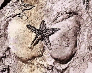
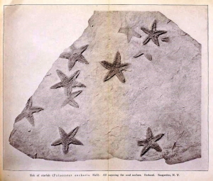
e Rev. Cole found and collected one slab, particularly rich in fossil starfish. He sent it off to the State Museum, and that quickly generated a lot of interest. It wasn’t long before Museum staff ascended Mt. Marion and located Cole’s starfish ledge. It must have involved a great deal of hard labor, but some 200 square feet of that sandstone ledge were eventually uncovered. This would have represented a large swath of Devonian age sea floor.  About 400 specimens of starfish of the species Devonaster eucharis were collected from it. Many of them were found in a fine state of preservation. They give us a very clear picture of their anatomy.   Altogether, this was a most remarkable discovery.

The largest of the starfish slabs, collected about 1911, has been (please forgive us) a star attraction at the State Museum for many years. What is more remarkable than the abundance of these starfish is their close proximity to a large number of sizable fossil clams. This was a Devonian age seafloor that was populated by clams of several different species. They were large clams too. And large clams, today, as probably in Devonian times, provide hearty meals for starfish.

Living starfish attack living clams and so, no doubt, did fossil ones. At least one fossil starfish was even found astride two open clam shells (third photo). The mouth ends of the starfish were commonly found facing the innards of the clams. It is a most astonishing juxtaposition of predator and prey, something the fossil record rarely preserves. These are Devonian age seafloor dramas and that’s what the Reverend Cole seems to have recognized.

And this last circumstance conjures up an image of another, even more remarkable bit of history. Those starfish were found in the process of their attacks. That means some sudden catastrophe must have instantly overwhelmed them. Geologists suspect that some sort of submarine avalanche must have swept across this seafloor just at the moments when those attacks were underway. Masses of soft sediment, swept by powerful currents, seem to have suddenly buried both predators and prey. This is something that does turn up in the fossil record – but rarely. It was a most unusual instant in time, preserved like a snapshot. Scientists are always wary of accepting the validity of such unlikely events, but the two of us have seen similar ledges and are inclined to think all this really happened just as has been described.

In the end, this was truly a great achievement for the Reverend Cole, a genuinely important one scientifically. We gain insights about Thomas Cole Jr. from all this. The Mt. Marion discovery could not have been a one-time stroke of luck. Cole must have spent enormous amounts of time exploring and looking for fossils.  He seems to have been a determined geologist.

We have never found the trail up to the fossil ledge. It is quite possibly off of Fish Creek Road. Do you know the way?

  Contact the authors at randjtitus@prodigy.com Join their Facebook page “The Catskill Geologist.”


Hw far away is the Devonian March 11, 202

in Uncategorized by

How far away is the Devonian?

The Woodstock Times – On the Rocks

Robert and Johanna Titus


   If you have been longtime readers of “On the Rocks” then you will know that we almost always write about geology that we have gone out to the field and seen for ourselves. We would like to depart from that in this issue. In fact, we are going to step out of Geology, itself, altogether. It all began when we were pondering the Devonian time period. That’s the geological chapter that extended from 419 to 359 million years ago. It’s an important unit of time here in the Catskills. All of the bedrock you see hereabouts was formed during the Devonian.  But what, we wondered, was going on in the universe that surrounded the Earth during that time? That got us pondering some more. We were being typical scientists and we were doing typical science thinking.

We realized that when you are looking into space, you are always looking into the past. When you are looking at the moon, you are looking at an image of light that departed it a short time ago. We asked our cell phone, and it told us that the image of the moon, that we see, left it 1.3 seconds ago. Our cell phone went on to tell us that light from the Sun is Eight minutes and 20 seconds old. We can’t actually see the Moon or the Sun; we can only see them as they were in the past. Do you think thoughts like this? Then you are a bit of a scientist.

We realized that there must be something out there that emitted light during the Devonian, but our cell phone was of no help. Our “smart” phone might have been stumped, but the Physics department at Hartwick College was not. We posed our question, by email, to the faculty of that department and in just a few minutes we got a very good answer. Living, breathing PhD physicists do these things all the time; they are very bright people. Dr. Kevin Schultz, Associate Professor of Physics, looked into NASA records and found a galaxy, poetically named UGC 12591. It lies just a little less than 400 million light years away from our Earth. That makes its light just a little less than 400 million years old. That light has been traveling toward the Earth all that time. When it reached the halfway point, Dinosaurs were just getting themselves started (that’s more science thinking). In short, that galaxy’s light was shining during the Devonian; it was there during the Devonian.


This NASA/ESA Hubble Space Telescope image showcases the remarkable galaxy UGC 12591. Classified as an S0/Sa galaxy, UGC 12591 sits somewhere between a lenticular and a spiral. It lies just under 400 million light-years away from us in the westernmost region of the Pisces–Perseus Supercluster, a long chain of galaxy clusters that stretches out for hundreds of light-years — one of the largest known structures in the cosmos. The galaxy itself is also extraordinary: it is incredibly massive. The galaxy and its halo together contain several hundred billion times the mass of the Sun; four times the mass of the Milky Way. It also whirls round extremely quickly, rotating at speeds of up to 1.8 million kilometres per hour! Observations with Hubble are helping astronomers to understand the mass of UGC 1259, and to determine whether the galaxy simply formed and grew slowly over time, or whether it might have grown unusually massive by colliding and merging with another large galaxy at some point in its past.

Would you like to see this Galaxy? Well you need to look into the westernmost region of the Pisces-Perseus Supercluster. That is an enormous chain of galaxy clusters which extends across some 250 million light years of space. It is regarded as one of the largest “things” found in the cosmos. UGC 1259l is big; it is four times the size of our Milky Way Galaxy. That makes it four times bigger than everything you can see in the night sky. Think about that for a moment. The bad news is that you won’t be able to actually look at UGC 12591; it’s too far away. Our photo was taken by the Hubble Space Telescope. If you don’t have access to the Hubble you won’t be able to see it yourself.

That galaxy is out there; it is that far away. But Hubble is not just looking far into space; it is looking far into the past. This column’s photo is of the galaxy as it was when lower Devonian tropical seas were invading New York State. Our local limestones are as old as the image you see in this column. That light was in transit while the trees of the fossil Gilboa Forest were growing. That light was geologically ancient at the very times when all the rocks you see around here were forming. We scientists ponder such things.

We should specify that we are not that smart; we paraphrased much of this article from a NASA publication. Dr. Schultz helped. We hope that Bob Berman will forgive our trespassing.

Contact the authors at randjtitus@prodigy.net. Join their facebook page “The
Catskill Geologist” Read their blogs at “thecatskillgeologist.com.”

“Where the boys are” Mar. 4, 2021

in Uncategorized by

Where the boys are.

The Woodstock times

On the Rocks, Jan. 24, 2019

Robert and Johanna Titus


You might remember the discovery of the Hyde Park mastodon. That was back in 1999. A local family, the Loziers, wanted to enlarge the pond that was in their backyard. When work was underway, they noticed what they thought was a log. That turned out to be the limb bone of a mastodon. Weeks of intense excavation by hundreds of volunteers resulted in the retrieval of an almost complete skeleton. It, eventually, was mounted and is on display at the Paleonto0logy Research Association Museum in Ithaca.

The animal was an adult male between 30 and 40 years in age. It was speculated that he was walking on the pond’s thin ice when he fell through and drowned. But is that it; is that the whole story? Maybe not. Recently, an article in a professional journal called Current Biology focused on another type of elephant – the mammoth. Researchers were studying the genetics of 98 Siberian mammoths. They were surprised to find that 69 of them were males. When they studied the literature, they found that this was the norm. Wherever large numbers of mammoths (and probably mastodons) were found, similarly large percentages of them were males.

They reasoned that, at birth, there likely had been an even numbers of males and females. So, what had happened to all those males? Why had so many of them died and, more importantly, why had they been preserved in such disproportionate numbers? Here is where we come across one of the leading philosophies of geology: “the present is a key to the past.” When geologists (and paleontologists too) come across a quandary from the distant past, they look to the present for a solution.

In this case, the biology or better the sociobiology of modern elephants may offer a solution to the problem. Modern day elephant herds consist of females and juveniles. They are led by experienced older females. Male elephants live solitary lives or are found in smaller male herds. The thought is that experienced female matriarchs can lead their herds away from dangers that they have, from life experiences, learned about. But males, especially solitary males, are more likely to behave in reckless manners. They are risk takers and that leads to what mammoth researchers labeled as “silly” deaths. Such males are more likely to fall through ice or sink into bogs. We have read about one particularly disturbing example. One male mastodon was found still standing in a small pond deposit. He may have died a slow death. When such things happens, their corpses are likely to end up buried where they can be preserved and, many thousands of years later, discovered by especially bright primates. Members of female herds die undramatic deaths in locations where they are not likely to be preserved.

Contact the authors at randjtitus@prodigy.net. Join their facebook page “The Catskill Geologist.” Read their blogs at “thecatskillgeologist.com.”

TheDevil’s Tombstone Feb. 25, 2021

in Uncategorized by

The Devil’s Tombstone

On the Rocks

Robert and Johanna Titus


Have you ever been to the Devil’s Tombstone? That’s a very sizable boulder at the Devil’s Tombstone Campground in the eastern Catskills. Make your way to Rte. 214 and head north until you reach Stony Clove Gap, a great canyon that cuts through the mountain there. You can park right in front of the boulder. It’s a lot of rock; it does look like a giant tombstone with its nearly rectangular shape and almost, but not perfectly, upright positioning. It’s certainly worth visiting and there are good hiking trails in the vicinity – come warmer weather.

Devil’s Tombstone

But the Devil’s tombstone may be more than just an oddity. It forms a striking image, begging for some sort of explanation. There has been widespread hypothesizing that it is a stone monolith, somehow manipulated into its present state by a long-ago prehistoric culture. We heard that story decades ago and never gave it much thought. It is claimed that the Tombstone lies near the northwestern end of something called the Hammonasset Line. That is a geographic line that points to Council Rock on Long Island, a similarly large boulder. Furthermore, it is said that its compass direction matches the alignments of both the winter and summer solstices.

Patterns such as these call for attention. A scientist seeks to find a solution using the famed, but not widely understood, “scientific method.” The first step (of five) in the scientific method is to define the problem that needs solving. Ours is simple: what is the Devil’s Tombstone and how did it get to be what it is? The second step in the method is to study the problem and gather as much knowledge about it as possible. The third step is to describe hypotheses that offer potential solutions to the problem. It is always better to have as many hypotheses as possible; it is not always likely that the first one to come to mind will turn out to be the “winning” solution.  After that comes step four, perhaps the most important: falsification. One by one the available hypotheses are tested. Each one should generate if/then statements. If the hypothesis is correct, then it follows that something else should be true. One by one the hypotheses are tested and, one by one, many of them fail the testing process and are falsified. If all goes well, in the end only one hypothesis will remain and may well come to be seen as the solution: something scientists formally call a scientific theory. The theory is regarded as the highest level of explanation in science; it is thought to have been proven, as thoroughly as humans can prove anything.

The stone monolith idea for the Devil’s Tombstone is a compelling hypothesis but it deserves to be joined by others; if it can survive competing challenges then if may well rise to the lofty level of scientific theory. Finding other hypotheses is our intent in this column. We have spent some time exploring the Devil’s Tombstone vicinity and we have been combing the geologic literature for the Stony Clove area as well. That has taken us through step two of the method.

Let’s go to step three – hypothesizing. We have developed two more of them. The first is that the Devil’s Tombstone may have formed as the result of it having fallen downhill from the steep slope rising above it. That may sound unlikely, but any hypothesis, no matter how unlikely should be tested. We, in fact, had no trouble finding at least one good very nearly vertical boulder up the road a bit. It was surrounded by a large jumble of other nearby boulders, all in various inclinations, all of which were equally unlikely. These had clearly all tumbled downhill to where they are today. Our gravity hypothesis has passed a test–sort of. Gravity could have, similarly, produced the Devil’s Tombstone, but we were just not happy with this notion. This hypothesis predicts that there should be a lot of other gravity-slide materials very near Devil’s Tombstone. The Tombstone is isolated and that is troubling.

Steeply inclined boulder up the highway from the Devil’s Tombstone

We went back to step two of the method. We studied ice age geology maps of the area, published by the New York State Museum in 1935 and 1983 and soon had another hypothesis. Glacial geologists have long understood that, at the very end of the Ice Age, one final advance of the ice had thrust its way through Stony Clove, heading south. It was very possible that such advancing ice had carried the Tombstone along with it and deposited it where we see it today. When the ice melted away, the Tombstone was left in its unlikely steep slope. The Tombstone would be what is called a glacial erratic. This is an interesting and appealing hypothesis but, still, its curious inclination and isolation remained as problems.

So, how do you test this hypothesis? The ice age erratic hypothesis, in fact, does generate at least one good prediction. If the Devil’s Tombstone was glacial in origin, then we should be able to find similar boulders elsewhere, especially in similar ice age settings. We went looking and we found a good one. The town of Windham is known to have had had a glacier passing, east-to-west, through it exactly at the same time the Stony Clove ice was active. And, there, at the west end of Windham, just past the Fire Department, was something we have heard is called “Cabin Rock.” It even has its own historical highway marker. And, like Devil’s Tombstone, it is very nearly vertical. But there is something else; it is still partially buried in glacial sediments; Thus, it could not have been erected by a prehistoric culture. It must be a true glacial erratic.


Cabin Rock. Photo by Deb Allen

Our glacial erratic hypothesis seems to be just as good as the monolith one. But, is it a better hypothesis? There are few, if any, doubts about our Cabin Rock interpretations, and they should work equally well for Devil’s Tombstone. How do we decide about the Tombstone? The monolith hypothesis generates a very strong prediction. If this was an important location on the Hammonasset Line and if the Hammonasset Line was, indeed, an important cultural institution, then there should be some archeology there, and perhaps a lot of it. If there is sufficient archeology then the monolith hypothesis looks good; if not, then it would seem to be falsified.

We argue for the erratic hypothesis. But we are not archeologists, so we can only await archeological evidence. It’s spring and right now flints should be easy to spot.

==================================================================

Contact the authors at randjtitus@prodigy.net. Join their facebook page “The Catskill Geologist,” Read their blogs at “thecatskillgeologist.com.”

1 14 15 16 17 18 41
Go to Top